Medway Local Plan (Regulation 18, 2024)
9.1 Vision for access and movement in Medway
9.1.1 The River Medway is a key asset, providing a strong sense of place and identity. However, the river bisects the area and movement is constrained by three main crossings. The severance caused by the river, past commuting flow patterns and travel behaviour, the legacy of post-war development designed for the car, generous car parking provision in dense employment areas and the existing public transport offer make for a challenging environment in which to accommodate Medway's development needs. Crucially, new development must not reinforce historic travel patterns or car dependency; rather, it will support a place-based vision for access and movement, and a sustainable future for Medway and its communities.
9.1.2 Medway's location in north Kent gives rise to additional opportunities and challenges associated with wider growth, in particular the proposed LTC. The LTC is a proposed road crossing of the Thames estuary that would link Kent and Essex. New destinations, infrastructure and technologies are emerging along with increasing prominence of the decarbonisation agenda.
9.1.3 The 'net zero' target followed the Paris Agreement signed at the United Nations Climate Conference in 2015 (COP21) and the UK parliament passing legislation in June 2019 to reduce greenhouse gas emissions to zero by 2050. A net zero target recognises that it will be difficult to remove some emissions pre-2050, however these could be offset to ensure the UK's balance of emissions is zero.[98]
9.1.4 The integration of land use and transport planning has an important role to achieve net zero. In short, the planning of new development needs to shift from a mitigative to a creative approach, i.e. leading with a vision.[99] In this way, and further to the Council's declaration of a Climate Emergency, a place-based vision for access and movement provides the basis for local living on an everyday basis. This calls for policies to ensure new development helps to reduce trips through local living, before considering how to increase the proportion of the remaining trips taken by active and public transport.
9.1.5 Development proposals will describe how they support the place-based vision for access and movement:
(46) Vision for Access and Movement in Medway
By 2041, Medway is an accessible place where people can meet most of their daily needs in their local area, such as schools, grocery shopping and places to socialise and exercise.
Space for home working has been provided in every new home, while co-working spaces have reduced the need to travel for people who are more likely to be able to work remotely.
A growing network for active travel converges on urban centres following the successful implementation of a Local Cycling and Walking Infrastructure Plan (LCWIP).
Urban centres will be characterised by design interventions to create a healthier, safer and more equitable environment for people.
Car clubs, demand responsive transport and e-scooters provide other credible transport choices.
The Hoo Peninsula has reduced car dependency and achieved a higher level of self-containment to facilitate local living in an age of increased remote working, while local employment opportunities are available at Kingsnorth and the Isle of Grain. Travel choice to/from the rural area has been improved through planning and investment in public transport.
Villages are less car dependent with increased home working supporting local services and amenities, and demand responsive transport is removing the barriers posed by distance to traditional public transport stops.
Digital commerce has been supported through the protection of existing distribution and warehouse uses, particularly those near to the urban area, to enable efficient courier services by ultra-low emission vehicles and cargo bikes.
The LTC and the Blue Bell Hill improvement scheme, along with rail timetable and station enhancements, have improved connections to wider destinations for work and leisure.
9.1.6 The levels of change required are unprecedented and equate to an 80 per cent reduction in carbon emissions from surface transport by 2030. The remaining 20 per cent of carbon emissions from surface transport would need to be eliminated by 2050.
9.1.7 No single intervention, or even a combination of interventions, will achieve the required 80 per cent reduction in carbon emissions from surface transport by 2030. In particular, over-reliance on the mainstream uptake of electric vehicles would reinforce car dependency. Furthermore, an 80 per cent reduction would require increasing the share of trips made via walking, cycling and electric public transport in the best practice scenarios that previous evidence suggests is possible.
9.1.8 The place-based vision for access and movement marks a shift from the traditional 'predict and provide' approach to the latest best practice 'vision and validate' approach.[100]
9.2 Monitoring and managing development
9.2.1 The Strategic Transport Assessment (STA) is informing the preparation of the new Local Plan. It involves iterative assessments of cumulative impacts associated with committed development and future development up to 2041. The STA will identify the necessary interventions, phasing and funding of mitigations for future development, and provide for the monitoring and managing of future development.
9.2.2 The STA has been tailored to meet the requirements of National Highways and the neighbouring Local Transport Authority, Kent County Council, to demonstrate a reasonable worst-case scenario in terms of traffic generation. It is the basis for a Statement of Common Ground supporting cross border strategic planning, by providing certainty for stakeholders in terms of the maximum highway capacity enhancements required to 2041.
9.2.3 The STA will establish a vehicle trip budget. This is aligned with a reasonable worst-case scenario. Committed developments would benefit from the first tranche of vehicle trip credits, followed by site allocations. Vehicle trip credits for unimplemented consents that subsequently expire would be recycled.
9.2.4 The STA will set out developer contributions for the package of transport mitigations across individual site allocations. This will be based on the distribution of new trips routing through junctions that would require mitigation.
9.2.5 Some elements of the package of transport mitigations are likely to be required earlier in the plan period. Therefore, the Council will seek opportunities to forward fund these elements to ensure full funding is in place.
9.2.6 However, it will be important to monitor and manage the implementation of the package of transport mitigations; it may be increasingly difficult to realise the place-based vision for access and movement once more highway capacity is delivered, which is based on a reasonable worst-case scenario. Development proposals should therefore be incentivised to demonstrate trip generation that would be lower than the vehicle trip credit set in the STA.
9.2.7 The 2019 amendments to the Community Infrastructure Levy (CIL) Regulations will enable the pooling of developer contributions in an infrastructure fund towards the package of transport mitigations. This will provide an alternative to developers being required to implement specific off-site infrastructure requirements through Section 106 agreements. Section 106s for individual site allocations will require payment of developer contributions into the infrastructure fund.
9.2.8 In order to allow developers to spread the cost of their contributions and to maintain a revenue stream, the trigger points for payments prior to commencement and/or completion will be agreed through the development management process.
9.2.9 Appropriate Grampian-style conditions may be imposed on grants of planning permission to ensure development occupations are controlled prior to the implementation of elements of the package of transport mitigations.
9.2.10 Medway Council would be responsible for the monitoring of vehicle trip credits and the collection of developer contributions, along with funding from all relevant public sources.
9.2.11 The exact approach to securing the implementation of mitigations through Section 106 planning obligations or other legal agreements, including Section 278 agreements, will be agreed through development management process.
(9) Policy DM15: Monitoring and Managing Development
As a minimum, development proposals for site allocations will demonstrate how vehicle trip generation would be 10 per cent lower than the vehicle trip credit set in the STA. This target is intended to positively challenge developers to pursue a creative approach, however full policy compliance should ensure that this is achievable.
Developer contributions towards the package of transport mitigations will be due in line with the Infrastructure Delivery Plan (IDP) or the outcome of a Medway-wide Monitor and Manage Mitigation Strategy.
Development proposals in urban centres, including site allocations, are exempt due to their accessible location, providing they comply with all other transport-related policies in this Local Plan.
Development proposals for 'windfall'/unforeseen sites will also be expected to make proportionate developer contributions towards the packed of transport mitigations.
9.2.12 The STA will comprise a robust and proportionate evidence base, prepared in consultation with National Highways and Kent County Council. However, planning for a reasonable worst-case scenario is incompatible with the need to shift from a mitigative to a creative approach. In practice, impacts associated with future development should reflect a policy-on scenario and take account of wider issues and developments.
9.2.13 This policy is concerned with realising the place-based vision for access and movement and not the reasonable worst-case scenario. The cumulative effect of trip generation across site allocations being lower than the vehicle trip budget set in the STA could be significant, however this would require the commissioning of a Medway-wide Monitor and Management Mitigation Strategy. This could avoid the need for some elements of the package of transport mitigations and their developer contributions which could otherwise be invested in development quality and other forms of necessary infrastructure.
9.2.14 Moreover, the full delivery of the package of transport mitigations could undermine the place-based vision for access and movement. It would be inappropriate to seek a full developer contribution (based on the reasonable worst-case scenario) if a development proposal can demonstrate how trip generation would be lower than the vehicle trip budget set in the STA. Therefore, a proportionate developer contribution discount is available.
9.2.15 A Medway-wide Monitor and Management Mitigation Strategy, is appropriate due to:
- future uncertainty in travel patterns, which may result in more sustained home working;
- the potential for the highway mitigations to create induced demand and reinforce car dependency;
- trip generation associated with traditional employment density assumptions, i.e. the number of employees per square metre, as a result of changes in workplace settings; and
- the potential for a comprehensive improvement scheme for Blue Bell Hill, which would seek to accommodate local growth and require new development in Medway to make a proportionate contribution, thus avoiding the need for relatively minor abortive works.
9.3 Active travel interventions
9.3.1 The River Medway is a defining feature of the area, providing a strong sense of place and identity. The local character of the river and its edges varies along its length, from extensive areas of intertidal habitat to historic military uses and industrial facilities. A series of spectacular meanders, framed by steep escarpments, create the opportunity for stunning views and connections between the urban quarters. It also provides opportunities for sport and recreation, however access is restricted in some areas due to historic uses and environmental constraints.
9.3.2 The river represents an important transport corridor for commercial and leisure traffic. The introduction of a new river crossing and a riverside path could facilitate sustainable transport and address the restrictions that apply to pedestrians and cyclists who are unable to use the Medway Tunnel, or where the local road network is not conducive to walking and cycling.
9.3.3 A riverside path or boardwalk will establish new infrastructure that inspires place-making and how people move around the area. A defined route would be a draw for residents and visitors, linking key heritage sites, stations with town centres, the universities and workplaces, supporting healthier lifestyles and cultural activities. It would be a focus for quality public spaces.
9.3.4 The highest quality place-making standards will be realised along the urban waterfront, with public spaces as focal points, and increased access to the riverside and the river itself. Where appropriate, this will align with the route of the King Charles III England Coastal Path that runs along Medway's frontage with the river and estuaries.
(9) Policy T20: Riverside Path
Waterfront development proposals will incorporate public space to facilitate walking and cycling and demonstrate the highest design standards, including Local Transport Note 1/20 (Cycle Infrastructure Design) and Sport England's Active Design guidance.
Development proposals will demonstrate how any impacts will be mitigated.
Opportunities to provide linkages with other path networks should be explored where these are compatible with other policies and do not result in impacts on coastal designated sites.
9.3.5 The LCWIP has identified cycling and walking improvements required at the local level. This enables a long-term approach to developing local cycling and walking networks, ideally over a 10-year period. LCWIPs represent best practice to provide high quality cycling and walking networks. The Council will seek funding to deliver interventions identified in the LCWIP to provide for high quality cycling and walking networks. In the meantime, the disused Chatham Waters Line presents a clear opportunity to contribute towards the place-based vision for access and movement.
(8) Policy DM16: Chatham Waters Line
The Policies Map shows safeguarded land for a new active travel corridor, linking the riverside around Chatham Maritime and Gillingham Riverside with Gillingham town centre.
Development proposals which compromise this policy will be resisted.
9.3.6 A strong emphasis on the river and the promotion of cycling and walking can help to deliver multiple elements of the vision, strategic objectives and wider policy outcomes. Responses to the consultation process generally supported the proposed vision which highlights the river itself and its strategic role. Natural England suggested that the Riverside Path policy could encourage opportunities to provide linkages with other path networks, subject to impacts on coastal designated sites.
9.3.7 The disused Chatham Waters Line to Gillingham station could make a significant contribution to the place-based vision for access and movement, for example as an active travel corridor or transitway. It provides a significant opportunity to address the severance between communities, and to enhance links between neighbourhoods, through improved walking and cycling routes.
9.4 Grain Branch
9.4.1 The government has described its strategic vision for rail, including commitments to expand the network to boost housing and economic growth, reinforce the importance of rail freight to support the economy and the environment and to explore opportunities to restore routes withdrawn during the 1960s and 1970s.[101]
9.4.2 Passenger services were withdrawn from the Grain Branch in 1961, however the line continues to facilitate the import/export of aggregates, along with rail freight associated with the aviation fuel storage depot and Thamesport activity.[8] Network Rail's 'South East Route: Kent Area Route Study' indicates that the Grain Branch is underutilised.[102] As part of the consultation in preparing the Kent Area Route Study, the Council emphasised its potential role in making the Hoo Peninsula a sustainable location for growth, while maintaining freight movements during off-peak periods. Network Rail subsequently included the Grain Branch in the final Kent Area Route Study as part of Network Rail's 30-year strategic vision and options for third party funders.
9.4.3 The geography of the peninsula and its position in relation to the River Medway means that development in this location is less likely to impact on the wider road network. Engagement with Network Rail's Strategic Planning Team found that a rail passenger connection at Sharnal Street presents the only opportunity to significantly increase rail capacity in Medway, supporting wider sustainable transport.
9.4.4 A rail passenger connection at Sharnal Street would provide a focus for future growth and improved travel choice. Moreover, it would:
- underpin a wider strategy in conjunction with exemplary approaches to design and green infrastructure;
- serve an improved employment offer at Kingsnorth; and
- allow for increased rail freight.
(13) Policy DM17: Grain Branch
The Policies Map shows safeguarded land for new rail infrastructure, including a station, route alignment and buffer stop zone.
Development proposals which compromise this policy will be resisted.
9.4.5 National planning policy expects the planning system to actively manage patterns of growth in support of several objectives, including the promotion of walking, cycling and public transport use and to avoid and mitigate any adverse effects.[103] Sites and routes should be protected, where there is robust evidence, in developing infrastructure to widen transport choice and realise opportunities for large scale development.[104] The Grain Branch policy is considered to be in line with these aspects of national planning policy.
9.4.6 Many commuters from the Hoo Peninsula currently drive from villages to stations at Strood, Gravesend or Ebbsfleet; a continuation of this travel pattern is unsustainable. This will exacerbate congestion on the A228, which in turn contributes to the poor air quality on Four Elms Hill, itself a designated Area Quality Management Area. A potential future rail offer, together with improved bus services, supports sustainable travel on the Hoo Peninsula.
9.5 Riverside infrastructure
9.5.1 The River Medway is a key asset, providing a strong sense of place and identity. It is highly visible from some areas, particularly from public areas of the waterfront and areas of higher ground. However, in some areas it is less accessible due to historic military and industrial uses. Historically the river has played a functional role in the transportation of goods to wharves, reflecting the area's manufacturing and industrial heritage. Some of this activity continues today, where some areas are characterised by the infrastructure associated with a range of economic activities, from aggregates importation to marine engineering and leisure activities.
9.5.2 London Thamesport and Medway's docks and wharves are of regional importance, facilitating the bulk transport, handling and processing of minerals, waste and other defined materials. A network of piers, jetties, slipways, steps and stairs are interspersed along the urban stretches of the river, although some facilities are in a poor state of repair.
(11) Policy T21: Riverside Infrastructure
Riverside infrastructure associated with the transport of minerals, waste and other defined materials will be safeguarded in accordance with national planning policy.
The existing network of piers, jetties, slipways, steps and stairs will be safeguarded to support the potential for visitor and river taxi services and to accommodate visiting vessels, while any new facilities will be encouraged. Riverside infrastructure will be required to comply with the requirements of conserving the designated environmental features of the estuaries and river. Development must demonstrate adequate mitigation and no loss of protected or priority habitats or species, unless the impacts are not significant at a waterbody scale.
9.5.3 National planning policy requires the planning system to afford significant weight on the need to support economic growth and productivity, taking into account both local business needs and wider opportunities for development.[105] In addition, local planning policies should require local plans to safeguard existing, planned and potential infrastructure for: the bulk transport, handling and processing of minerals; the manufacture of concrete and concrete products; and the handling, processing and distribution of substitute, recycled and secondary aggregate material.[106] However, national planning policy also stipulates that local plans should reflect changes in the demand for land and be informed by regular reviews of both the land allocated for development and of land availability.[107]
9.5.4 The Riverside Infrastructure policy intends to reinforce Medway's strategic location in the Thames Estuary. Ports, docks and wharfage will be safeguarded to support existing business sectors and to attract businesses requiring such facilities where feasible.
9.5.5 The Council supports the potential for new services on the river to complement the regeneration and tourist attractions along the waterfront, therefore the retention of and access to wharves and public piers will be promoted, subject to the need to meet the requirements of conserving the important environmental features of the designated river and estuarine habitats.
9.6 Marinas and moorings
9.6.1 A marina is a dock or basin with moorings and supplies for yachts and small boats. It can include activities such as boat sales, repair facilities, chandlery, boat storage, club house and parking. It is effectively a small port that is used for pleasure rather than trade, often with hotels, restaurants and bars ancillary to the main function. Marinas therefore can have a very urban appearance and can generate a significant amount of vehicular movement. Rural areas are therefore generally not preferred locations for marinas of this scale of supporting facilities.
9.6.2 However, within or adjoining an existing built-up area, a marina can, if well designed, be a positive asset. Where existing or historical facilities are located in smaller settlements or rural areas it may be appropriate to support the development of larger or more permanent marina facilities.
(4) Policy T22: Marinas and Moorings
Proposals for upgraded or new high quality marina facilities and amenities will be supported in principle.
Planning permission for marinas and moorings will be granted if the application demonstrates how the proposed development:
- Will meet a proven need.
- Is required for the proper functioning of an existing facility or to enhance and improve access to the waterway.
- In an urban location, is supported by the provision of other commercial leisure uses at an appropriate scale, without undermining the role, vitality and vibrancy of town centres.
- Will have adequate land-based utility infrastructure and supporting facilities, including sewage, waste, water, secure storage and washing.
- Will not conflict with neighbouring uses, have a significant adverse impact or result in unacceptable environment consequences. A detailed Habitats Regulations Assessment may be required.
- Has specific regard to the SPAs, Ramsar sites, Sites of Special Scientific Interest and the Marine Conservation Zone.
- Adheres to the Council's policy for the North Kent SAMMS – 'Bird Wise'.
- Will not result in increased flood risk further downstream or elsewhere.
- Will not adversely impact on amenity, particularly with regard to the waterways, in terms of access, servicing and car parking provision.
- Will not have a significant adverse impact on the highway network.
9.6.3 Existing marinas operate at or close to full capacity. Facilities for visiting vessels are currently limited, but there is significant potential for growth. It is recognised that better co-ordination between marina operators would improve Medway's leisure boating offer. Evidence at the regional level indicates that there is a shortfall of marina provision along the North Kent coast between Ramsgate harbour and facilities around the Medway Estuary.
9.6.4 Therefore, proposals for upgraded or new high quality marina facilities and amenities will be supported in principle. In particular, river access to shore facilities and attractions requires improvement.
9.6.5 Moorings can have a negative impact on the landscape of the waterway. In urban locations, marinas and sites used historically for the function would be appropriate for permanent moorings. In other areas recreational boat users require short stay or overnight moorings necessitating only mooring posts and public footpath access to limit the impact on the waterways and natural and marine environment. The development of moorings, other than overnight stays, will be judged on their merits, having regard to their impact on the landscape, access, parking and cumulative provision.
9.6.6 Residential houseboat moorings occupy areas that could be utilised for additional marina berthing. Many of the houseboats have limited facilities and can create negative environmental impacts.
9.7 Aviation
9.7.1 Rochester Airport is a general aviation facility catering for leisure, business, training, heritage and emergency service uses. A small part of the site itself falls partly within the Tonbridge and Malling administrative area.
9.7.2 Adjacent to and on either side of the airport is the Innovation Park Medway. The Council approved the Innovation Park Medway Masterplan in March 2019, subject to comment from National Highways. The masterplan provides the vision and guidance for the consideration of development proposals, while a LDO and supporting Design Code sets out what development is permitted and the associated conditions.
9.7.3 The Innovation Park Medway sites benefit from Enterprise Zone status enabling the creation of skilled employment opportunities. There are no plans to transform the airport facility into a commercial airport, with regular scheduled and/or chartered passenger flights, and the operations will be subject to conditions to mitigate and manage the impacts.
(6) Policy T23: Aviation
Rochester Airport will provide an enhanced aviation facility for business, public service, training, heritage and leisure uses, and support the development of a strategic gateway and an economic hub.
9.7.4 Under the policy theme of sustainable transport and specifically in relation to general aviation airfields, the government requires a Local Plan to recognise the importance of maintaining a national network of general aviation airfields and their need to adapt and change over time, taking into account their economic value in serving business, leisure, training and emergency service needs.[108]
9.7.5 There is a small aviation operation at Stoke on the Hoo Peninsula. The Stoke facility, which primarily caters for microlights, is limited in scale and constrained by high voltage power lines and other features. It is not proposed to safeguard this facility.
9.8 Urban logistics
9.8.1 Wider changes in retailing and logistics have created a new demand for industrial land in urban areas. Products ordered online are rarely delivered from the central warehouse to customers' doors; they need to be consolidated before the 'last mile' delivery is completed by couriers. However, the pressure to deliver housing has reportedly resulted in significant losses of industrial land across the country. The demand and constrained supply of logistics floorspace has been reported in the last 10 years due to population growth, urbanisation and changes in retail and manufacturing.[109] New approaches to warehousing are also emerging.
9.8.2 These structural changes to economic sectors and the way areas need to function present new challenges for local planning policy. It is nonetheless a national requirement that local plans proactively encourage sustainable economic growth, having regard to local industrial strategies and other local policies for economic development and regeneration.[110]
9.8.3 Storage and distribution premises comprise B8 uses under the Use Classes Order 1987 (as amended). Land use records contain over 600 B8 uses in Medway. Larger units are located in industrial estates and business parks, while the majority are relatively small units, typically dispersed across the main urban area.
(5) Policy T24: Urban Logistics
The loss of existing B8 (storage or distribution) uses will be resisted, unless it can be demonstrated that the site is no longer suitable for this activity, for example due to amenity issues.
9.8.4 The policy will support the logistics sector to develop in Medway and encourage efficient courier distribution, which is likely to mitigate local traffic congestion. The logistics sector is likely to prefer sites near main roads, providing convenient and economic access to urban areas. B8 uses in the main urban area are more likely to support the use of low emission vehicles due to their limited range and this would help to address poor air quality.
9.8.5 The pressure to deliver housing is likely to place undue pressure to convert or redevelop existing B8 uses. The Council's annual monitoring has found that 164 new homes replaced B8 uses since 2017. The continued and cumulative loss of B8 floorspace could undermine the ability of the logistics sector to serve communities and businesses in Medway.
9.8.6 The Strategic Housing and Economic Needs Assessment highlighted the rising demand for logistics space in the Thames Estuary Corridor. As one of the largest conurbations in the South East, Medway is reportedly an area of significant interest for logistics operators given the large population and manufacturing sector requiring distribution.[111] Medway has underperformed in this sector, with areas either side of the Dartford Crossing traditionally more attractive.[112]
9.8.7 The sector has seen recent expansion with new activity, such as London Medway Commercial Park, a major new facility at Kingsnorth. Furthermore, the proposed LTC is likely to increase demand for sites in Medway, creating new employment opportunities.
9.9 User hierarchy and street design
9.9.1 Development proposals should adhere to the prioritisation of pedestrians and cyclists and second – so far as possible – to facilitating access to public transport.[113] Streets, parking and other transport considerations are integral to the design of schemes, and contribute to making high quality places.[114]
9.9.2 Almost all journeys start and end on foot and therefore the pedestrian should be the focus of street design. The design of streets should prioritise users in the order illustrated in Figure 7.
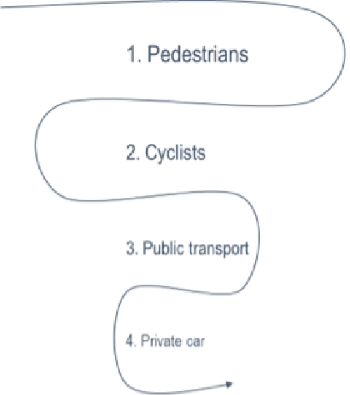
Figure 7: Street User Hierarchy
9.9.3 A development, depending on its scale and the context, will require a range of streets and spaces with differing characteristics. Certain planning applications require a Design and Access Statement to be submitted and this should show how street design has been considered.
9.9.4 A Design and Access Statement should be informed by best practice guidance, such as Local Transport Note 1/20 (Cycling Infrastructure Design), the Chartered Institute for Highways and Transportation's 'Streets and Transport in the Urban Environment' series and the Kent Design Guide.[115],[116],[117] In addition, Sport England's Active Design (2015) guidance promotes sport and physical activity through the design and layout of the built environment. Depending on the location of the proposed development, the Design Manual for Roads and Bridges may be the required standard.
9.9.5 If there is the possibility that a street will serve further homes or businesses in the future, for instance if there is an adjacent allocated site which is likely to be developed (and accessed through the first site), then the streets should be designed to the appropriate standard, or be capable of being altered in the future. No 'ransom strip' or other gap should be left between the adopted highway and the site boundary, so that a durable street layout can be provided that can accommodate future changes.
(8) Policy T25: User Hierarchy and Street Design
Planning permission for major developments will be granted if the Design and Access Statement submitted as part of the application demonstrates how the proposal:
- adheres to the user hierarchy (see Figure 7);
- provides for an appropriate range of streets and spaces, meeting the needs of all users;
- integrates with adjacent built-up areas, with no 'ransom strip' or other gap left between the adopted highway and the site boundary to accommodate future changes;
- promotes active frontages, particularly in relation to publicly accessible areas, for the purposes of natural surveillance and creating characterful places; and
- ensures appropriate street furniture and signage is included only when necessary for reasons of safety, orientation or comfort of residents and visitors.
9.9.6 Revised national planning policy places greater emphasis on the role of design and requires the prioritisation of non-car modes of transport. The preparation of the policy has been informed by the publication of best practice guidance, notably the Chartered Institute for Highways and Transportation's 'Streets and Transport in the Urban Environment' series.
9.9.7 The multiple benefits of walking and cycling for individuals and the community are well documented and promoted, for example through the Living Streets campaign, not least in terms of addressing public health, environmental and economic issues as a result of traffic congestion. Research suggests the lack of attractive routes and perceptions of crime are factors that deter walking and cycling.[118] This is especially pertinent to Medway, where some areas are car dependent. New development must not replicate the unintended consequences of the past; this would only help to reinforce unsustainable travel behaviour and exacerbate traffic congestion.
9.9.8 There are many examples of fragmented development in Medway due to the way in which urban areas have expanded over time, typically by patterns of land ownership and the legacy of development designed for the car. This has resulted in enclaves which are characterised by low levels of external connectivity (i.e. the number of access points) and internal permeability (i.e. various convenient routes though an area).
9.9.9 Individual and household travel choices are complex; however certain forms of street layout are more likely to be conducive to walking and cycling. Such design considerations are also important factors for specific groups. For example, a legible environment, incorporating a range of street types, has been emphasised in urban design guidance to help people living with dementia to lead an active and independent life for longer.[119]
9.9.10 Due to the way in which development will be built out over time, it is crucial that proposals demonstrate careful consideration of every opportunity for connections to integrate with adjacent areas, whether existing or likely to come forward in future.
9.10 Accessibility standards
9.10.1 The '15-minute neighbourhood' concept enables people to 'live local'. This means people can meet most of their everyday needs within a 15-minute walk or cycle from their home, such as schools, grocery shopping and places to socialise and exercise.[120]
9.10.2 Providing access to affordable, integrated public transport and new forms of shared mobility such as e-bikes, e-scooters and electric vehicle car clubs is vital. This would help to ensure such means of transport are credible for the medium and longer distance journeys that are responsible for most surface transport emissions.[121]
9.10.3 It is important to note the need for flexibility on the application of the accessibility standards, taking into consideration the specific characteristics of the particular location or route, e.g. topography, attractiveness and safety.[122],[123]
(9) Policy T26: Accessibility Standards
Strategic and major development proposals for new homes will describe how they meet the following accessibility standards within 15 minutes for local destinations:

Access to shared mobility, such as e-bikes, e-scooters and electric vehicle car clubs is encouraged through a Travel Plan for medium and longer distance journeys.
Strategic and major development proposals for new homes will also be planned to enable the maximum walking distances to bus stops as part of medium to longer distance journeys:
| Situation | Maximum walking distance (metres) |
|---|---|
|
Core bus corridors with two or more high-frequency services Single high-frequency routes (at least every 12 minutes |
500 400 |
|
Less frequent routes Town/city centres |
300 250 |
The journey times and distances will be demonstrated by the characteristics of the route itself, rather than as the crow flies / notional circular catchments.
9.10.4 New development will need to reduce trips through local living – linking to local services, before considering how to increase the proportion of the remaining trips taken by active and public transport.[124] This is consistent with national planning policy, which expects local planning policy to minimise the number and length of journeys needed through an appropriate mix of uses across an area and within larger scale sites, and to provide for high quality walking and cycling networks and supporting facilities.[125]
9.10.5 The 15-minute standard will help to ensure that the number and length of daily journeys is reduced, resulting in carbon savings. Furthermore, this will help to achieve public health benefits and more equitable and inclusive communities by removing the transport barriers to jobs and services faced by people without access to a car.[126]
9.10.6 The proportion of elderly people is increasing. Along with people with children, buggies and heavy shopping, elderly people are more likely to be sensitive to the range of factors (e.g. distance, topography, attractiveness and safety) that would inform accessibility to bus services. The maximum walking distances to bus stops are intended to enable the bus to compete effectively with the car and to benefit a wide range of people with differing levels of walking ability.[127]
9.11 Transport assessments, transport statements and travel plans
9.11.1 New developments, or the intensification of existing uses, can have a detrimental impact on the highway network by generating additional traffic, while new vehicular accesses can cause a road safety hazard or delays to other road users.
9.11.2 National planning policy requires all developments that generate significant amounts of movement to provide a Travel Plan, with applications supported by a Transport Assessment or a Transport Statement.
9.11.3 A Transport Assessment sets out transport issues relating to a proposed development and identifies measures required to improve accessibility and safety, and other measures to mitigate the anticipated transport impacts of the development. A Transport Statement is a simplified version of a Transport Assessment; this can be required where the anticipated transport impacts of the development are limited. A Travel Plan is a long-term management strategy, subject to regular review, for an organisation or site that seeks to deliver sustainable transport objectives.
9.11.4 National Highways are the highway authority, traffic authority and street authority for the Strategic Road Network (SRN), comprising of motorways and all-purpose trunk roads in England. The SRN is a critical national asset. National Highways works to ensure that it operates and is managed in the public interest, both in respect of current activities and needs as well as in providing effective stewardship of its long-term operation and integrity.
9.11.5 National Highways is a statutory consultee in the planning system. Proposals that could have an impact on the SRN should be informed by engagement with National Highways as early as possible. The following policy documents should be consulted when engaging with National Highways:
- Planning for the Future: A guide to working with National Highways on planning matters (2023).
- DfT Circular 01/2022: Strategic road network and the delivery of sustainable development.
9.11.6 An initial judgement on the need for a Transport Assessment, a Transport Statement and / or a Travel Plan for the sites allocated for development has been set out in the site-specific requirements (see Site Allocations). However, in addition to the transport evidence base supporting the Local Plan itself, Medway Council (as local transport authority), Kent County Council (as the neighbouring transport authority) and National Highways may need to be agree the scope to make a full assessment of development proposals on sites allocated for development. This underlines the need to seek early engagement, ideally during the pre-application stage.
9.11.7 The Council has adopted guidance for Transport Assessments which promotes the use of its traffic model.[128] The potential advantages may result in a more efficient planning process, leading to increased confidence, reduced costs and higher quality developments. This will also help to ensure that the Council can effectively plan for growth.
9.11.8 Development proposals on the Hoo Peninsula will adhere to an Area-wide Travel Plan. This reflects the specific circumstances of this rural area. This will identify mode share targets and specific measures aligned with the anticipated phasing of new development. The Area-wide Travel Plan will set out positive and practical measures; it will need to be flexible, but sufficiently detailed and meaningful. Having established a baseline, monitoring arrangements will assess the performance of the road network and, should targets not be met and/or the performance of the road network found to be unacceptable, set out any additional measures required.
(10) Policy DM18: Transport Assessments, Transport Statements and Travel Plans
Development proposals that will generate a significant amount of movement will be supported by a Transport Assessment, Transport Statement and/or a commitment to provide a Travel Plan.
The requirement for a Transport Assessment or Transport Statement will need to be agreed with National Highways for development proposals that impact on the SRN. National Highways, in conjunction with the Council as local highway authority, will agree the scope of the Transport Assessment or Transport Statement at an early stage. National Highways will need to be satisfied that development proposals will not materially affect the safety, reliability and/or operation of the SRN.
Early discussion will provide an initial judgement on the need for and scope of a Travel Plan. The following aspects of a Travel Plan should be specified in a Section 106 agreement, or the subject of a condition, as appropriate:
- A timetable for the preparation, implementation, monitoring and review of the Travel Plan.
- The appointment and funding of a Travel Plan Coordinator to be responsible for the management of the Travel Plan, including the relationship with the local planning authority and/or other key stakeholders.
- The overall aim and objectives (e.g. to determine mode share targets) of the Travel Plan.
- Requirements for occupiers and future occupiers.
- The measures to be implemented, such as the provision of transport infrastructure or services.
- A monitoring and review programme for surveys.
- Any sanctions where the targets are not being met, and how and when they should be applied.
- Any procedure for the variation by means of amendment, substitution or addition of targets or measures.
Development proposals on the Hoo Peninsula will adhere to an Area-wide Travel Plan.
9.11.9 Transport is one of the most high-profile matters associated with development. Consultation on the emerging Local Plan confirmed concerns about existing pressures on transport networks and their capacity to accommodate growth. These concerns were substantiated in the traffic modelling undertaken to support the new Local Plan, i.e. the STA.
9.11.10 The STA will provide an understanding of the cumulative impact of sites allocated for development in terms of the capacity of the highway network and the associated safety issues. This is a high-level piece of work, intended to help identify locations which can accommodate growth. However, the site-specific impacts are beyond the scope of the STA.
9.11.11 National Highways' 2023 policy document states that development proposed which has not been subject to an appropriate level of assessment, or is not included or consistent with an approved Local Plan, should be subject to early engagement to agree the scope of work required to make a full assessment.
9.11.12 Planning obligations are considered to be the most appropriate mechanism for securing an effective Travel Plan.[129]
9.11.13 The Area-wide Travel Plan to cover the Hoo Peninsula will help to:
- reassure local communities in providing for better transport;
- deliver the proposed place-based vision for access and movement;
- satisfy the requirements of the relevant transport authorities;
- provide for a smooth planning process; and
- address air quality and noise impacts.
9.12 Parking
9.12.1 The Council's current vehicle parking standard was adopted in 2004 and revised in 2010. The residential vehicle parking standard provides for a minimum number of parking spaces per dwelling size. The relevant documents are set out in Appendix B. The 2010 addendum states that:
Reductions of the standard will be considered if the development is within an urban area that has good links to sustainable transport and where day-to-day facilities are within easy walking distance.
9.12.2 This is intended to provide flexibility in the application of the vehicle parking standard to achieve the most effective use of land and reduce travel demand.
9.12.3 In addition to the overall quantity, best practice guidance emphasises the need to follow a design-led approach, recognising that there is no single solution to vehicle parking provision. In short, vehicle parking provision should respond to the location, type, size and tenure of development proposals.[130],[131],[132]
9.12.4 Cycling is recognised for the contribution it can make as a sustainable and healthy form of transport for trips within our towns and between rural communities. To support this, the Council is committed to providing measures that make the choice to cycle a more natural one. The cycle network and associated infrastructure, including cycle parking, are essential to encourage cycling as a viable means of transport.
(16) Policy DM19: Vehicle Parking
Planning applications for residential and non-residential development will be determined in accordance with the adopted vehicle parking standard, including future revisions, subject to consideration of site-specific circumstances or material considerations that indicate otherwise.
The Council's current vehicle parking standard is set out in Appendix B. This is anticipated to be updated over the plan period. The 2010 addendum provides for flexibility in the application of the vehicle parking standard in order to optimise the density of development and reduce travel demand.
Vehicle parking will be consistent with any maximum vehicular trip generation set out in an associated Travel Plan.
For residential development, Design and Access Statements will demonstrate how the proposed vehicle parking adheres to best practice design principles. This is comprehensively set out in the Chartered Institute for Highways and Transportation and the Building for a Healthy Life guidance.
Where garages are to be provided, additional curtilage and/or on-street parking will be required.
All on-street and off-street parking bays will accommodate an electric vehicle charging point. There may be circumstances where compliance with this aspect of the policy would make the development unviable. In each case these circumstances would need to be fully demonstrated to warrant a departure from compliance with this aspect of the policy. Any departure should be able to demonstrate how on-street and off-street parking bays will be capable of accommodating electric vehicle charging points.
Electric vehicle car club membership is encouraged through a Travel Plan. Some parking bays will need to be set aside solely for car club vehicles; they will be located to achieve the greatest exposure and use of the vehicles, subject to any specific requirements of the operator.
If on-street controls are needed, the potential for parking in neighbouring streets will need to be considered. Residents in neighbouring streets will need to be involved in preparing any Traffic Regulation Order (TRO). A developer contribution will be sought for any TRO, along with any additional enforcement.
Where there are no on-street restrictions proposed, a design-led allowance for on-street unallocated parking is preferred for visitors, deliveries and any additional vehicles owned by residents.
Retirement and other residential developments with particular occupancy controls will be expected to take a site-specific approach to vehicle parking provision.
(8) Questions: Transport
Click the speech bubble icon to the left to respond.
(9) Policy DM20: Cycle Parking and Storage
Planning applications for residential and non-residential development will be determined in accordance with the adopted cycle parking standard, subject to consideration of site-specific circumstances or material considerations that indicate otherwise.
Long-term cycle parking facilities for residents, visitors and/or employees of the development will be conveniently located, safe to use, secure, weatherproof and be well integrated into the building and/or layout of the site.
Short-term cycle parking facilities should be conveniently located in relation to the public realm, provide effective security for cycles and be safe to use.
For dwelling houses, individual provision should be made within the private garden area.
For flatted developments and commercial uses, communal cycle stores should be provided in individual cages or containers, situated in secure locations where access is restricted to residents. Where on-site provision is demonstrably not practical, a developer contribution towards secure on-street residential parking or maintenance of strategic cycle routes will be sought.
Access to shared mobility, such as e-bikes and e-scooters, is encouraged through a Travel Plan.
9.12.5 Transport issues are among the most frequent and contentious issues raised during the previous consultations on the emerging Local Plan. Ill-considered vehicle parking provision was often cited in written responses and during public exhibitions as a matter of particular concern, given the potential for existing neighbouring streets to be adversely affected, giving rise to the potential for neighbourhood dispute.
9.12.6 A response to an early round of consultation in the plan-making process highlighted recent case law as to what can and cannot be contained in a SPD. An SPD cannot contain policy identifying development and use of land; this should be set out in the Local Plan itself. As a result, and for clarity purposes, the Council's current vehicle parking standard is set out in Appendix B.
9.12.7 It is generally accepted that the most desirable streets are dominated by lined trees with cars parked in the street, either parallel to the pavement or at an angle, providing a buffer for pedestrians. In contrast, cars often dominate the street scene of cul-de-sacs developed since the 1960s.
9.12.8 More recently, car parking is often placed to the rear of houses in parking courts. Parking courts are designed with the intention to reduce the visual impact of cars, maintain the overall required number of parking spaces and enable the free movement of vehicles. The streets in such developments are often relatively narrow to reduce construction costs. However, drivers often choose to park on the street in front of houses, where there may be better surveillance. This can lead to instances of vehicles parking with two wheels on the pavement, impacting on the public realm and pedestrian safety, causing obstruction to public transport, emergency and delivery vehicles, and reducing the scope for children using the street for play.
9.12.9 'Home zones' have been advocated to encourage more street activity through the integration of play, socialising and car parking. Such designs often incorporate traffic calming measures, signage, public seating, planting and street surfacing to promote uses in addition to vehicle movement.
9.12.10 There are further disadvantages to parking courts, including the inefficient use of land to accommodate parking, smaller rear gardens, lack of surveillance and residents preferring to use their rear door, resulting in a loss of street activity. A design-led approach is promoted in best practice guidance to achieve a high quality and actively used public realm, to enable developers to meet market expectations and to discourage inconsiderate parking.
9.12.11 Research indicates that the allocation of parking spaces can be inefficient.[133],[134] Car ownership levels will vary with the churn of occupants and their circumstances, therefore the allocation of most parking spaces will inevitably lead to households with too few or too many spaces. Visitors are more likely to require parking during the evening and at the weekend. There are times when demand for visitor parking coincides with the highest demand for resident parking, particularly in the evening, where there may be insufficient capacity and result in pressures on spaces and inappropriate parking.
9.12.12 In additional to a private car, some households may also need to park a commercial van. Some parking spaces may not be designed to accommodate larger vehicles and this can also lead to inconsiderate parking.
9.12.13 The latest iteration of the Viability Assessment assumed that schemes would provide electric vehicle charging points. It was noted that the costs of electric vehicle charging points vary and are falling, while in some cases the costs are covered in part by grants. An allowance of £250 per unit was allowed for.[135]
9.12.14 In the case of new developments and re-developments, good quality cycle parking should be designed in from the outset and not introduced as an afterthought. Cycle parking must be easy to use and accessed by all members of the community at all life stages and the need to lift or drag the bicycle at any time should be designed out of all new parking layouts.
9.12.15 Cycle parking should always give cyclists the confidence that their bicycle will still be there upon their return and therefore racks or other support systems should be conveniently sited and provide good security. Cycles are generally expensive goods. Parking and storage facilities that rely on the securing of wheels are unlikely to provide effective deterrents against theft or damage. It is much easier to remove cycle wheels without the need for tools. Cyclists are not likely to use communal cycle stores with limited security, and this could lead to storing cycles inside properties and/or on balconies, which can impact on amenity.
9.12.16 It is recognised that an affordable, reliable e-bike and e-scooter hire system could help to overcome parking and storage issues, ensuring people can benefit from cycling as an everyday mode of transport irrespective of income or their ability to store a bike at home.
[8] Soft sand, sharp sand, gravel, crushed rock and recycled rail aggregate.
[98] Royal Town Planning Institute (2021). Net Zero Transport: The Role of Spatial Planning and Place-Based Solutions. Available at https://www.rtpi.org.uk/media/9233/rtpi-net-zero-transport-january-2021.pdf [Accessed 28 June 2024]
[99] Ibid
[100] Ibid
[101] Department for Transport (2017). A Strategic Vision for Rail. Available at https://www.gov.uk/government/publications/a-strategic-vision-for-rail [Accessed 28 June 2024]
[102] Network Rail (2018). South East Route: Kent Area Route Study. Available at https://www.networkrail.co.uk/wp-content/uploads/2018/06/South-East-Kent-route-study-print-version.pdf [Accessed 28 June 2024]
[103] Department for Levelling Up, Housing and Communities (2023). National Planning Policy Framework. Available at https://assets.publishing.service.gov.uk/media/65a11af7e8f5ec000f1f8c46/NPPF_December_2023.pdf [Accessed 28 June 2024]
[104] Ibid
[105] Ibid
[106] Ibid
[107] Ibid
[108] Ibid
[109] Logistics Business (2024). Demand for Logistics Space over Next 5 Years. Available at https://www.logisticsbusiness.com/materials-handling-warehousing/distribution-centre-property/demand-for-logistics-space-over-next-5-years/ [Accessed 28 June 2024]
[110] Department for Levelling Up, Housing and Communities (2023). National Planning Policy Framework. Available at https://assets.publishing.service.gov.uk/media/65a11af7e8f5ec000f1f8c46/NPPF_December_2023.pdf [Accessed 28 June 2024]
[111] Medway Council (2024). About the Local Plan: Local Plan Evidence Base. Available at https://www.medway.gov.uk/info/200542/medway_local_plan_2041/1681/about_the_local_plan/4 [Accessed 28 June 2024]
[112] Ibid
[113] Department for Levelling Up, Housing and Communities (2023). National Planning Policy Framework. Available at https://assets.publishing.service.gov.uk/media/65a11af7e8f5ec000f1f8c46/NPPF_December_2023.pdf [Accessed 28 June 2024]
[114] Ibid
[115] Chartered Institute of Highways and Transportation. Streets And Transport In the Urban Environment. Available at https://www.ciht.org.uk/knowledge-resource-centre/resources/streets-and-transport-in-the-urban-environment/ [Accessed 28 June 2024]
[116] Department for Transport (2020). Cycle infrastructure design (LTN 1/20). Available at https://www.gov.uk/government/publications/cycle-infrastructure-design-ltn-120 [Accessed 28 June 2024]
[117] Kent County Council. Kent Design Guide. Available at https://www.kent.gov.uk/about-the-council/strategies-and-policies/regeneration-policies/kent-design-guide [Accessed 28 June 2024]
[118] The Guardian (2017). Unhealthy Britain: Half of Adults Walk Less Than a Mile a Day – Survey. Available at https://www.theguardian.com/society/2017/may/26/unhealthy-britain-half-of-adults-walk-less-than-a-mile-a-day-survey [Accessed 28 June 2024]
[119] Royal Town Planning Institute (2020). Dementia and Town Planning. Available at https://www.rtpi.org.uk/practice-rtpi/2020/september/dementia-and-town-planning/ [Accessed 28 June 2024]
[120] Royal Town Planning Institute (2021). Net Zero Transport: The Role of Spatial Planning and Place-Based Solutions. Available at https://www.rtpi.org.uk/media/9233/rtpi-net-zero-transport-january-2021.pdf [Accessed 28 June 2024]
[121] Ibid
[122] Ibid
[123] Chartered Institute of Highways and Transportation. Streets And Transport In the Urban Environment. Available at https://www.ciht.org.uk/knowledge-resource-centre/resources/streets-and-transport-in-the-urban-environment/ [Accessed 28 June 2024]
[124] Ibid
[125] Royal Town Planning Institute (2021). Net Zero Transport: The Role of Spatial Planning and Place-Based Solutions. Available at https://www.rtpi.org.uk/media/9233/rtpi-net-zero-transport-january-2021.pdf [Accessed 28 June 2024]
[126] Department for Levelling Up, Housing and Communities (2023). National Planning Policy Framework. Available at https://assets.publishing.service.gov.uk/media/65a11af7e8f5ec000f1f8c46/NPPF_December_2023.pdf [Accessed 28 June 2024]
[127] Chartered Institute of Highways and Transportation. Streets And Transport In the Urban Environment. Available at https://www.ciht.org.uk/knowledge-resource-centre/resources/streets-and-transport-in-the-urban-environment/ [Accessed 28 June 2024]
[128] Medway Council (2018). Transport Assessments: Guidance Note. Available at https://www.medway.gov.uk/downloads/file/2334/transport_assessments_guidance_note [Accessed 28 June 2024]
[129] Transport for London. How We Secure and Enforce Travel Plan Targets. Available at https://content.tfl.gov.uk/how-we-secure-and-enforce-travel-plan-targets.pdf [Accessed 28 June 2024]
[130] English Partnerships (2006). Car Parking: What Works Where. Available at https://webarchive.nationalarchives.gov.uk/ukgwa/20090413234926/http://www.englishpartnerships.co.uk/qualityandinnovationpublications.htm [Accessed 28 June 2024]
[131] Chartered Institute of Highways and Transportation. Guidance Note: Residential Parking. Available at https://www.ciht.org.uk/media/4395/guidance_note_-_residential_parking.pdf [Accessed 28 June 2024]
[132] Urban Design Group (2020). Building for a Healthy Life. Available at https://www.udg.org.uk/publications/othermanuals/building-healthy-life [Accessed 28 June 2024]
[133] English Partnerships (2006). Car Parking: What Works Where. Available at https://webarchive.nationalarchives.gov.uk/ukgwa/20090413234926/http://www.englishpartnerships.co.uk/qualityandinnovationpublications.htm [Accessed 28 June 2024]
[134] Chartered Institute of Highways and Transportation. Guidance Note: Residential Parking. Available at https://www.ciht.org.uk/media/4395/guidance_note_-_residential_parking.pdf [Accessed 28 June 2024]
[135] Medway Council (2024). About the Local Plan: Local Plan Evidence Base. Available at https://www.medway.gov.uk/info/200542/medway_local_plan_2041/1681/about_the_local_plan/4 [Accessed 28 June 2024]