Medway Local Plan (Regulation 18, 2023)
5. Developing a Spatial Strategy
Please provide your comments where the speech bubble is shown.
Development needs
(41) 5.1 The Local Plan will include a Policies Map, which will show how land is allocated for new development, such as housing and employment, and where land is protected, such as environmental designations for nature and landscape. The Policies Map and Key Diagram help to communicate Medway's spatial strategy – how we are planning for the future.
(29) 5.2 A Local Plan should be positively prepared for sustainable development. It should not be used to stop development that is needed for our growing and changing communities. The Plan should seek to direct and manage growth, so that it provides land for homes, jobs and services, as well as protecting the area's natural resources and historic features.
(30) 5.3 Government directs Local Planning Authorities to use its 'Standard Method' in determining the scale of housing needed over the plan period. This Standard Method formula for Local Housing Need identifies a need for 1,667 homes a year in Medway, or around 28,500 over the plan period to 2040. This level of housing need is greatly higher than rates of housebuilding seen in Medway for over 30 years. The formula reflects dated demographic projections and has been heavily criticised across the country and there is currently some uncertainty with Government policy. At the time of writing, the Government had not yet published its response to the consultation on revisions to the National Planning Policy Framework, which included consideration of the Standard Method formula.
(29) 5.4 The Council has raised concerns in Government consultations about the Standard Method. A key matter for Medway is the marked variation in levels of housing needs generated by the Standard Method based on projections from 2014, in comparison to use of more recent demographic projections for Medway's growth. This matter was considered in the Medway Housing and Demographics report supporting the Local Housing Needs Assessment published in 2021, and is illustrated in Figure 1 below, which is an extract from the report. The dwelling-led Standard Method scenario is clearly significantly higher than use of other approaches to forecasts. The Government considers that this method is appropriate to meet its housebuilding ambitions to tackle pressures in the housing market. Notwithstanding the concerns regarding the methodology, it has to be recognised that there is a housing crisis, particularly regarding affordability and there is an absolute need to provide the right homes in the right places to meet Medway's growing needs and the requirements for those desperately needing a good quality home. There are many existing residents in Medway living in over crowded and/or substandard conditions which is unhealthy or living at home with parents well into their late 30's because they simply cannot afford to live independently in the area they wish to continue to live.
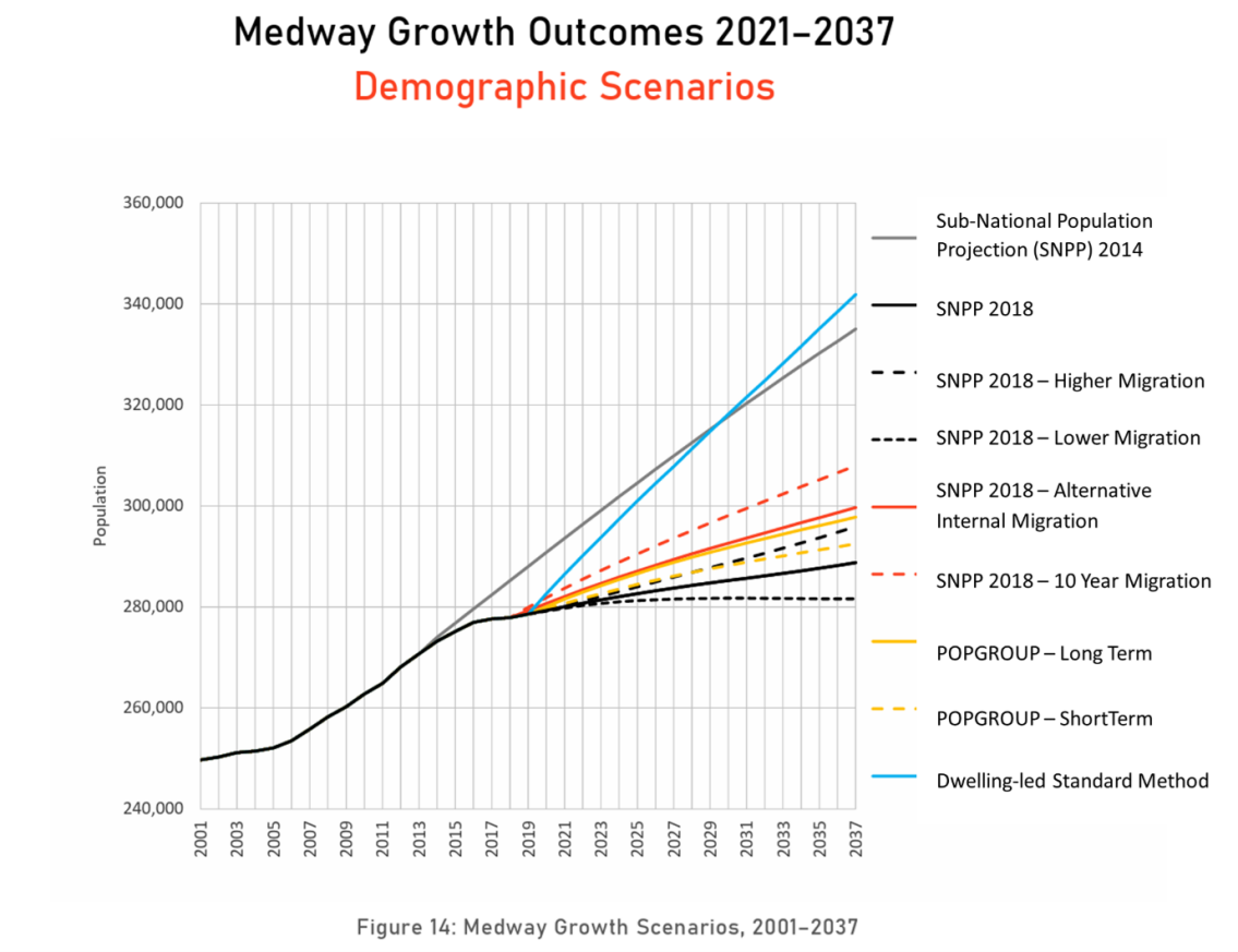
Figure 1: Extract from Medway Housing and Demographics report, 2021 (page 15) showing alternative approaches to forecasting housing needs
(11) 5.5 The Council will be reviewing the outcomes of Government consultations and anticipated policy updates in preparing the draft Local Plan for publication next year.
(25) 5.6 The Council is collating a comprehensive evidence base to inform the new Plan. All potential sites will be assessed for their ability to deliver sustainable development, considering constraints and mitigations, and how they could meet the objectives of the Sustainability Appraisal and objectives for the Plan. The Council needs to demonstrate that the growth strategy set out in the Plan can be delivered, to provide certainty and confidence in Medway's growth. Potential sites and locations will be tested against a range of criteria, including transport impacts and viability.
(26) 5.7 Work to date has highlighted some critical constraints. National Highways has indicated that there is insufficient capacity in parts of the Strategic Road Network to accommodate significant growth. National Highways has identified capacity and safety concerns with M2 Junction 1. Although this is outside of Medway's boundary, it is a key junction for the area, and many residents and workers travel through this junction regularly. There are no plans to upgrade this junction as part of National Highway's plans for the Lower Thames Crossing (LTC). Without a clear scheme in place to address these issues, development of jobs and homes across north and mid-Kent will be stymied. The Council is working with neighbouring authorities and wider stakeholders to prioritise action on M2 Junction 1. This matter would need to be addressed in the Local Plan, with policies showing how impacts could be mitigated and improvements delivered.
(9) 5.8 In addition to this current issue, further transport impacts are expected with the development of the LTC. The LTC is focused on a defined scheme for its primary route and tunnel. The scheme does not provide for improvements that may be needed to parts of the surrounding roads network that would be impacted as a result of the new crossing. The new crossing is forecast to generate new trips, as well as re-routing existing journeys, as drivers divert from Dartford.
(20) 5.9 This is a particular concern for Medway, as the modelling assumptions used in planning for the LTC underestimate the amount of development growth that would be expected in the new Local Plan. There are concerns that the road network will not have the capacity to accommodate the higher levels of homes and jobs planned in Medway. This raises uncertainty for the capacity of the highway network to meet the full scale of development needs over the plan period. This could be a strategic constraint to development and the Plan would need to reflect lower levels of growth in Medway, with the consequent impact on delivery of new jobs and homes to Medway's need and related affordability of homes.
(15) 5.10 Further consideration will be given to potential impacts on the environment, especially the designated habitats and landscapes which form a large part of Medway's area, and strategic infrastructure needs. The Council will need to assess how negative impacts can be avoided, or mitigated, such as through delivery of new services.
(36) 5.11 In addition to assessing how to meet Medway's needs for 28,500 new homes over the Plan period, the Council must consider if there is capacity to provide up to an additional 2,000 homes to help meet Gravesham's housing needs, following a request from the neighbouring borough.
Potential land supply for development
(10) 5.12 The housing needs for Medway over the plan period of 2022-2040 is for 28,339 homes. Providing for a buffer to allow for some sites not coming forward for development would lift the total plan period need to over 29,000 homes.
(14) 5.13 There is an existing 'pipeline' of sites with planning permission for over 7,500 homes, not yet built, which contribute towards meeting the total need in the Plan. Authorities can also make allowance for 'windfall sites' – those that come forward for development outside of Local Plan allocations. Taking account of these two sources of supply, the Council is assessing options to make provision for site allocations for over 19,000 homes to meet needs in Medway.
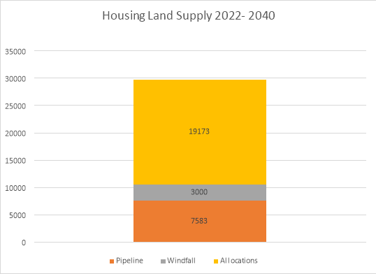
Figure 2 – potential sources of housing land supply for Local Plan
(19) 5.14 This is a high level of need and the Council has carried out a comprehensive and iterative review of potential sources of land for development allocations. The Council has produced a Land Availability Assessment (LAA) to be published with this consultation document. The LAA has been informed by a Call for Sites, where the Council invited developers, landowners and other parties to put forward sites for consideration as potential development allocations. Planning officers also identified sites from other sources, such as development briefs, the Brownfield Land Register and withdrawn planning applications. An initial high-level assessment has screened out sites that are too small. Further work will consider the scope for overcoming constraints to achieve sustainable development.
(19) 5.15 The LAA has identified land with the potential capacity for c 38,200 homes, which will proceed to the next stage of detailed assessment, along with the Sustainability Appraisal process. Many of these sites are subject to constraints, including environmental considerations, infrastructure requirements and viability. It is likely that many of these sites will not be found suitable, available and achievable for sustainable development and will be removed at the next stage of assessment and Sustainability Appraisal. A range of mitigation measures will be required to achieve the scale of housing needed for the Plan. The scale of proposed growth is anticipated to have significant impacts across Medway. This level of housebuilding would mean the transformation of urban centre and waterfront areas and large-scale development in suburban and rural areas.
(23) 5.16 The Council has identified four broad categories of locations where development could take place, reflecting Medway's geography. Indicative housing capacities from the LAA for the different areas are presented for each category (Note, this is NOT allocating numbers to allocated sites but merely reflects the LAA):
Category
Potential Housing Capacity (from LAA)
Urban regeneration
11,151
Suburban growth
9,680
Rural development
14,736
Green Belt loss
2,649
Total potential supply
38,216
Table 1: Potential sources of housing land supply by category
(14) 5.17 These broad locations are considered in more detail below.
Urban Regeneration
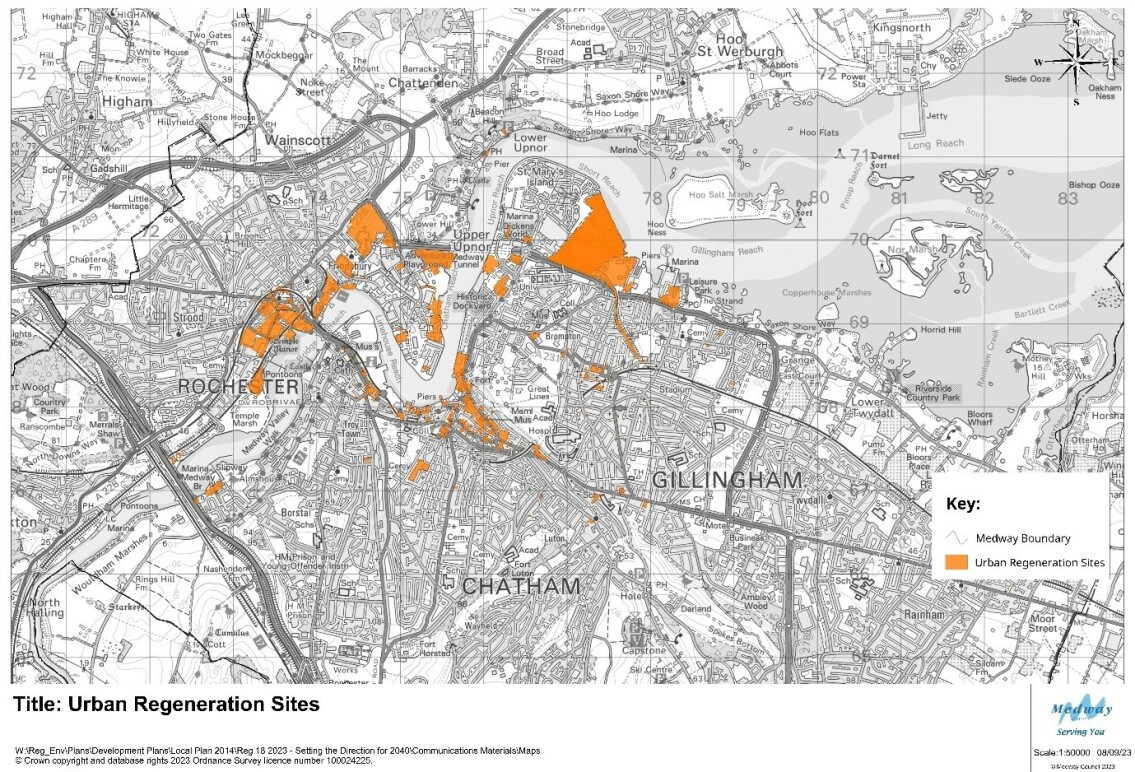
Map 1 – overview of potential sites for Urban Regeneration
Sites with the potential for urban regeneration could provide the capacity for 11,151 homes.
(22) 5.18 Medway has been successful in transforming its urban waterfront and centres in recent decades, with areas such as St Mary's Island, Chatham Waters, Victory Pier and Rochester Riverside. The Council has been leading on Medway's regeneration, setting out strategies to realise new opportunities, securing millions in external funding, preparing land for redevelopment, and working closely with partners and developers to deliver change. The Council is also identifying where it has underused sites that could make better use of brownfield land for new development, and is bringing forward new homes and business space in areas such as Chatham Waterfront. This commitment to urban regeneration continues to form an intrinsic part of our strategy for Medway's growth in coming years.
(14) 5.19 The new Local Plan will draw on the existing policies, strategies and programmes that promote the regeneration of Medway's urban centres and waterfront. This work creates a supportive policy environment for redevelopment in these areas. In drawing up the growth strategy for the new Plan, the Council's starting point is regeneration and making the best use of vacant or under-utilised brownfield land. Sites which are already identified in Council documents such as the town centre masterplans for Chatham, Gillingham and Strood, and development briefs for Strood Waterfront, are likely to be included as site allocations in the new Local Plan. Such sites could deliver thousands of homes, as well as commercial floorspace for businesses and services and contribute to our wider strategies for supporting our high streets and centres in adapting to wider changes in retail patterns.
(13) 5.20 The regeneration opportunities vary across Medway's urban area, reflecting the different characteristics of our towns. Some sites offer the potential for taller buildings and a modern urban character; other sites are more sensitive to the historic surroundings and their environmental setting. The Council recognises the distinctive and varied character of Medway. Urban regeneration does not mean a standard approach to density and design, but consideration of the most appropriate approach in different areas. The Council's work on the Chatham Design Code is assessing in detail how new development would best fit with the centre's heritage, landscape and infrastructure. It will provide guidance on building heights and massing, design of public spaces and transport links to ensure that redevelopment in central Chatham optimises the potential of the area. Similarly, the Chatham Intra Development Framework takes a heritage-led approach to managing potential change, reflecting the area's special character and historic significance. If such areas are to provide new homes, workspaces and services, it is critical that people and the environment are at the centre of plans – with green spaces, sustainable design, play areas, and places to rest and socialise. The Plan must promote a coherent strategy that looks at managing change to create an attractive and sustainable place for people to live, work and visit.
(27) 5.21 In addition to these sites, the Council is also considering the potential for wider development in urban waterfronts. Land has been promoted for redevelopment at Chatham Docks and Medway City Estate. These large sites could provide for new homes as well as workspace for businesses and services. Such major redevelopment would have a marked impact on the area and would involve the relocation of existing businesses.
Opportunities
(18) 5.22 The central urban areas benefit from good public transport links, existing services and businesses, universities and colleges and major visitor attractions. These offer sustainable locations for new development, in line with national planning policy. There are underused and vacant sites, reflecting changes in work and retail patterns over a number of years. These locations have the potential for higher density development, making the best use of previously developed land. The accessibility of town centre sites can offer attractive living environments for a wider range of people. Town centre regeneration is not limited to flats for younger people but has the potential to meet the needs of older people and families. The plan will need to reflect the needs of wider communities in shaping policies and allocations for central areas.
(19) 5.23 Vacant units on the High Street could be redeveloped with space for businesses and community services on the ground floor, with new homes on higher floors. As businesses, particularly office- based activities, look at new models of working, town centre sites could have an important role in diversifying our employment land offer.
Issues and Constraints
(9) 5.24 The continued success of urban regeneration in Medway will involve directing new homes to locations where everyday needs can be met; these locations are already – or could be – well-served by public transport for medium and long-distance journeys. If we do not achieve meaningful shifts in how people travel, the centres and surrounding roads will be subject to further congestion, with associated air quality and amenity issues, and development will be constrained by levels of car parking.
(11) 5.25 The waterfront is an important area for nature and much of the river in central Medway is a designated Marine Conservation Zone. This means that the impacts of development, such as light, noise and other disturbance on the river may need to be considered. As a coastal authority, Medway is also subject to the impacts of rising sea levels with climate change. This is a particular consideration in planning for the redevelopment of waterfront sites, and the need to futureproof buildings. Much of Medway's noted heritage is located in the central urban areas, such as the Chatham Historic Dockyard and its defences, and Rochester Castle and Cathedral. New development must be sensitive to the historic significance of its surroundings.
(11) 5.26 Sites considered in this development involve the redevelopment of brownfield sites, sometimes with demolition, conversion or land decontamination required. Development of such sites tends to have higher costs for these reasons, and this can affect viability, meaning that the sites are not attractive to the market, or lower quality schemes are built. The Council is testing the viability of sites through its work on the Local Plan and will consider how policy can encourage redevelopment in these areas. Some sites identified for potential allocations in the new Plan have not been proposed by land owners or developers, but from the Council's work in assessing land availability and development briefs. The Council will seek to engage with the development sector to encourage them to consider promoting their sites.
(17) 5.27 There are key opportunities for urban regeneration and potential for thousands of new homes. It will be important to ensure that homes are supported by services, including new schools and health facilities. Planning for major redevelopment must be for sustainable development.
(10) 5.28 There are sites promoted for development in urban areas which would involve significant changes to employment land at Chatham Docks and Medway City Estate. These raise issues on the possible re-location of existing businesses, as well as the types of new businesses that may be attracted to the areas. Conflict with surrounding land uses is also a key matter, particularly where residential areas may be coming forward next to busy employment sites. A strategic and comprehensive approach is critical to avoid piecemeal development that may not provide good living standards and could create tension with surrounding land uses.
Suburban Expansion
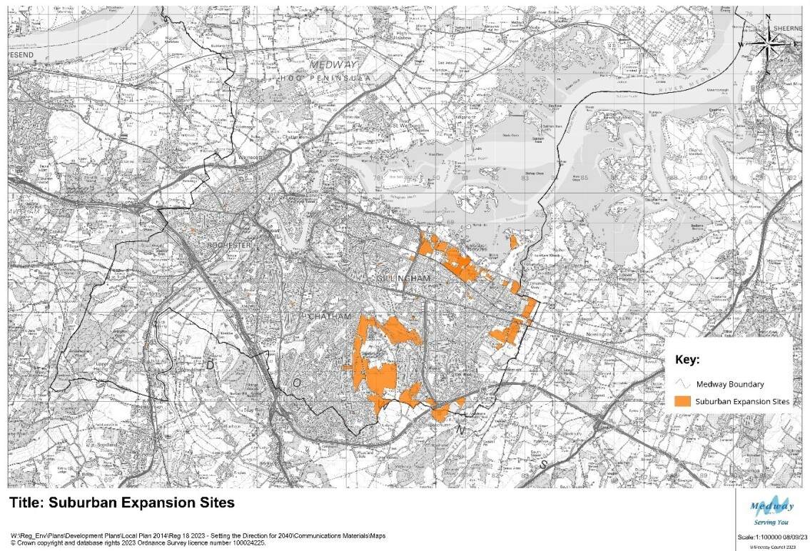
Map 2 – overview of potential sites for Suburban Expansion
Sites with the potential for suburban expansion could provide the capacity for 9,680 homes.
(34) 5.29 This category considers the areas for potential growth adjoining the existing urban areas to the south and east of Medway. These are largely located to the north and east of Rainham and in the Capstone and Hempstead area to the south. The existing suburban neighbourhoods are home to many of Medway's residents, and key services and employment areas. The undeveloped land around the suburbs is valued as a contrast to the large urban conurbation, providing important green lungs within an otherwise dense urban area and includes the popular country parks at Capstone and Riverside. Historically these areas have been important for farming, such as the north Kent fruit belt, from which the county gets its recognition as the Garden of England. There are key landscape links to the estuary in the north and the Kent Downs to the south. Car ownership rates are higher in this part of Medway, and there are congestion hotspots on the highways network, particularly along the A2.
Opportunities
(16) 5.30 The large towns and neighbourhoods in the south and east of Medway are popular places for people to live. Developers are actively promoting land in this area through the Local Plan and planning applications. Development on the green field sites in this category would be expected to be built out quickly, responding to market demand and more limited site constraints than brownfield sites.
(18) 5.31 Development of large sites in this location could provide opportunities to enhance sustainable travel options, making it easier and more attractive for people to walk, cycle and use public transport. The concept of the '15 minute neighbourhood', where communities can benefit from services on their doorstep, has relevance to growth plans in this area. New urban extensions could provide for local services and be designed to prioritise pedestrians rather than cars. Development at such a scale could also include new workspaces, closer to where people live.
Issues and Constraints
(16) 5.32 Much of the land around the north and east of Rainham is the best and most versatile farmland, although many fields are not in active agriculture use. The area to the south is within the setting of the Kent Downs Area of Outstanding Natural Beauty, and undeveloped land forms an important component of our green infrastructure networks. The area to the north lies close to the Medway Estuary, which is designated a Special Protection Area, Ramsar site and Site of Special Scientific Interest, recognising its international and national importance for wildlife.
(13) 5.33 The A2 is an important transport corridor, but experiences congestion and has been designated an Air Quality Management Area. There is a risk that major development in these suburban locations could generate further dependencies on car-based travel, adding to congestion and pollution, and undermining Medway's ambitions for sustainable development. Much of the potential development south of the M2 is anticipated to travel towards the M2 via junction 4 which may need to be improved to accommodate additional traffic.
(10) 5.34 Although potential sites could be developed in proximity to existing towns and neighbourhoods, there is not sufficient capacity in existing services, such as schools and health services, to cater for an increased population. New housing would need to make provision for expanded and new services. Similarly, schemes that focus on homes and not jobs and services could result in unsustainable development and increase people's need to travel.
(26) 5.35 Land in this area lies close to Medway's boundary with neighbouring authorities, particularly Swale and Maidstone. Development in these locations would potentially have a cross-border impact. Development to the east of Rainham would erode the strategic gap between Rainham and Newington and add further to the congestion and pollution issues on the A2. Development to the south around the Capstone Valley would potentially adjoin the development of the proposed 'Lidsing Garden Community' in Maidstone. The landowner is promoting a cross-border masterplan. There are a number of potential impacts, including transport, infrastructure and the natural environment.
Rural Development
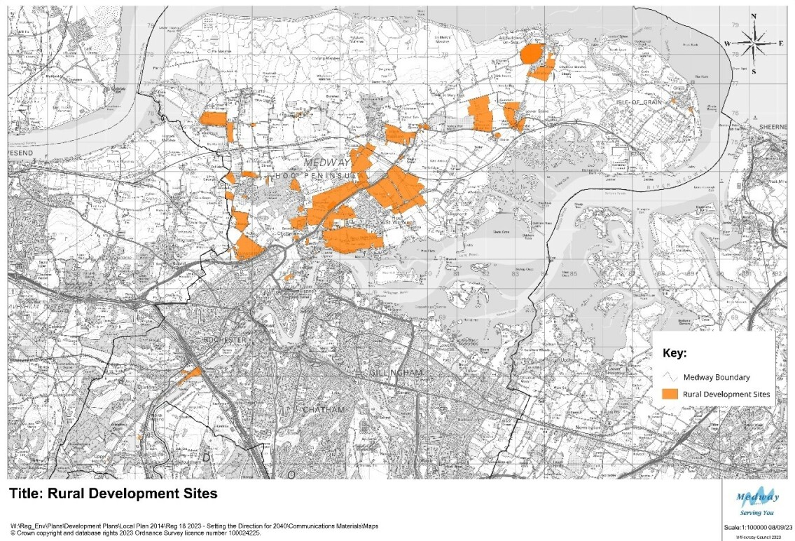
Map 3 - overview of potential sites for Rural Development
Sites with the potential for development in the rural areas could provide capacity for 14,736 homes.
(29) 5.36 Although Medway is largely an urban authority by population, the majority of its land is rural. Much of the countryside is on the Hoo Peninsula to the north of the borough, as well as the Medway Valley to the south west. Rural Medway is markedly different in character to the urban towns and neighbourhoods. The villages in the Medway Valley sit within the setting of the Kent Downs and the river. The Hoo Peninsula sits between the Thames and Medway estuaries. Much of the periphery of the peninsula is designated as Special Protection Areas (SPAs) and Ramsar sites, recognising its international importance for nature, particularly migrating birds. There are further Sites of Special Scientific Interest (SSSI) across the peninsula, which are of national importance. The coastal marshes and mudflats and areas of woodland shape the distinctive character and feel of the peninsula. These landscapes are valued for their sense of place and remoteness, all the more special, given their proximity to urban Medway.
(10) 5.37 The peninsula includes areas of the best and most versatile land for agriculture, and there is a strong farming presence. However, the area is also characterised by wider industries, particularly the legacy of the energy sector at Grain and Kingsnorth. These two large brownfield sites form an important part of Medway's employment land supply and offer unique opportunities for further jobs growth such as realising opportunities for green technology as the country moves to zero-carbon.
(9) 5.38 There are a number of villages on the peninsula, with the largest being Hoo St Werburgh. Hoo has a population of over 10,000 people and provides services, such as schools and sports facilities to the wider villages on the peninsula. However, many residents travel off the peninsula to reach workplaces, shops and other services. There are high levels of car ownership and public transport services are limited in a number of areas.
(12) 5.39 The vast majority of sites that have been put forward for potential development in rural Medway (outside of the Green Belt designation) are on the Hoo Peninsula. Most of the sites are promoted for housing led development, with the exception of the larger employment sites. It is noted that many of the sites promoted for development on the Hoo Peninsula are large scale, each potentially providing land for hundreds of homes.
Opportunities
(20) 5.40 There is significant land for potential development for homes, jobs and services on the Hoo Peninsula. The Council has recognised this potential through its work on the Local Plan, and considering options for how Medway can grow in the future. The Council has considered the potential for large scale growth on the peninsula through its work on the draft Hoo Development Framework which was published for consultation in 2022. The Housing Infrastructure Fund (HIF) programme sought to deliver improvements to transport and put measures in place to strengthen the local environment. These would provide certainty in planning for future development in the area, and in assessing sites across Medway in the context of constraints and possible mitigations in preparing the Local Plan.
(13) 5.41 In the absence of the HIF funding programme, the opportunities and issues still remain key considerations in the preparation of the new Local Plan. Large scale development around Hoo St Werburgh and neighbouring villages could provide for planned growth, where new housing is supported by new and improved services and infrastructure. Such development could also help to meet the Council's ambitions for greener growth, with higher environmental standards in construction, communities better connected for walking and cycling, and within easy reach of local services.
(5) 5.42 The peninsula also has a key role in Medway's economic development strategy, with major sites at Grain and Kingsnorth offering potential for new employment sectors and being regional hubs in energy and green technology industries, contributing to de-carbonisation of the economy. The area's environment also offers opportunities to develop green tourism, based on assets such as the estuaries and the spectacular shows of birdlife. Agriculture will continue to be an important land use for the peninsula.
Issues and Constraints
(7) 5.43 The Hoo Peninsula has significant potential for further development, as part of Medway's wider growth in coming decades. This is shown in the extensive number of sites promoted for development on the peninsula, and the scale of potential sites. However, there are a number of specific considerations for development on the peninsula.
(12) 5.44 The area's special and distinctive environment is a primary consideration. The Local Plan will set out a strategy, not just for development, but also for strengthening our green infrastructure networks and sites. Biodiversity, landscape, and water management are just some of the key matters in environmental planning. The Council will assess the potential impacts of possible development sites on different aspects of the natural environment, with specific attention to the designated areas, such as SSSIs and the SPAs.
(13) 5.45 A further strategic consideration is the capacity of infrastructure to support major growth on the Hoo Peninsula. Transport networks would need to be upgraded. The roads network is limited, with particular concerns on the capacity of Four Elms roundabout and congestion on the adjoining roads, which exacerbates air pollution. Bus services reflect the rural nature of the area, with reduced frequency compared to urban Medway. The Council will require major transport schemes to provide for sustainable transport choice and increase the capacity of the road network, to facilitate growth on the Hoo Peninsula.
(10) 5.46 Similarly wider investment is required in wider services, such as schools and health and leisure facilities, to support larger communities, as the existing infrastructure reflects the area's rural character and villages. Large scale growth would need careful planning for phasing and design to provide for sustainable development.
Green Belt Release
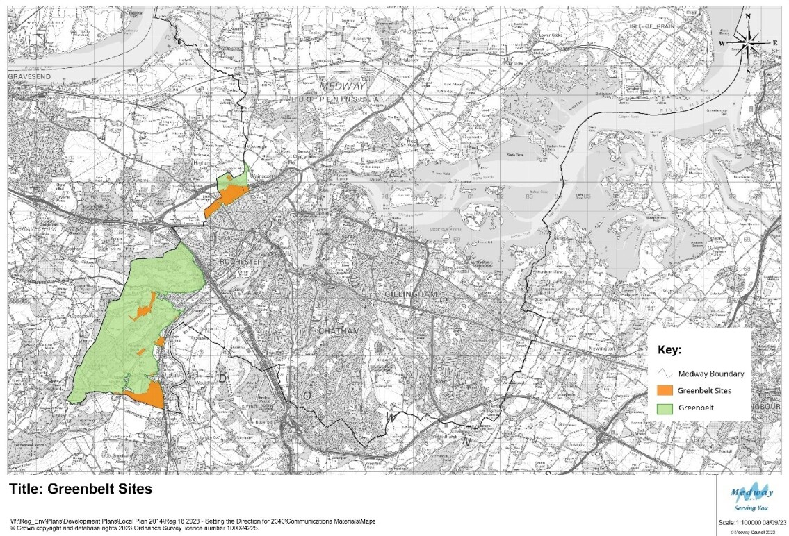
Map 4 – overview of potential sites for Green Belt release
Sites with the potential for development in the Green Belt could provide the capacity for 2,649 homes.
(12) 5.47 There is a common confusion with the technical jargon used in Planning between Green Belt and greenfield land. Green Belt is a specific policy designation around major cities. Greenfield is used to refer to undeveloped land, like fields, in contrast to brownfield sites, which have previously been developed. National planning policy attaches great weight to Green Belt policy which places limits on development. Greenfield sites do not have the same level of protection in national planning policy.
(8) 5.48 Land in the west of Medway forms part of the Green Belt around London. The Metropolitan Green Belt aims to stop the outward growth of Greater London into the surrounding countryside, towns and villages. National planning policy states that the principal aim of the Green Belt policy is to prevent urban sprawl by keeping land permanently open.
(11) 5.49 Just under 5% of land in Medway is designated as Green Belt. These areas adjoin Green Belt land in Gravesham and Tonbridge and Malling. Both of these boroughs have significantly higher proportions of land covered by the Green Belt designation. As well as preventing the outward expansion of London, at a more local level, the Green Belt prevents coalescence of towns and villages. It provides a strategic gap between Strood and Higham, and between Snodland and Halling. The Council has carried out a review of land in Medway in the Green Belt, which shows that the purposes of the policy are being met.
(10) 5.50 There is a strong presumption in national planning policy that Councils should seek to protect the Green Belt from development, and where needing to allocate land for growth, sites outside of the Green Belt should be considered in preference to Green Belt release.
Opportunities
(12) 5.51 In the context of high levels of housing need across Medway and neighbouring boroughs, Councils are looking at all options for how they can provide for sufficient homes in their Local Plans. The boroughs of Gravesham and Tonbridge and Malling both have high levels of land covered by the Green Belt designation. The Lower Thames Crossing is proposed to the east of Gravesend and this will involve significant change in the area between Gravesend and Strood. This context of major infrastructure investment needs to be considered in reviewing potential release of land in the Green Belt. In work on its emerging Local Plan, Gravesham Borough Council has identified a potential development allocation immediately to the west of Medway, near Strood. This would significantly narrow the Green Belt land in this location, and impact on the function of the remaining Green Belt land adjoining Strood in Medway. Developers are promoting separate sites in both Medway and Gravesham for Green Belt release. Development in Medway could provide for a limited number of homes, in proximity to transport networks and services in Strood.
(10) 5.52 A larger area of land in the Medway Valley across the borough boundaries of Medway and Tonbridge and Malling is being promoted through the Councils' respective Local Plans. This could form a cross-border strategic development, or separate allocations in the two Council areas. Development at this scale would provide for new services, including schools, as well as homes.
Issues and Constraints
(15) 5.53 In addition to the strong policy presumption against development in the Green Belt, much of the land in Medway's part of the Green Belt is also part of the Kent Downs Area of Outstanding Natural Beauty (AONB). The AONB designation and its setting is also afforded significant weight in national planning policy to protect land from major development. The potential cross-border proposal in the Medway Valley would have significant impacts on the AONB. The Council would be expected to evidence a case for development in such a location and how landscape impacts could be mitigated.
(6) 5.54 Both sites are located close to major transport corridors, which already carry high levels of traffic, and are forecast to be impacted by the LTC. There are queries as to the capacity of such sites to accommodate travel needs and to provide for sustainable transport options.
Employment Sites
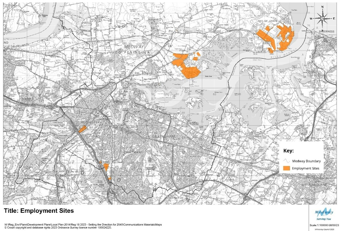
Map 5: overview of potential employment site allocations
(6) 5.55 A sustainable development strategy provides for homes, jobs and services. Housing sites in the strategy tend to attract the greatest interest, but it is important to draw up a balanced plan for Medway. This includes setting out our plan for boosting jobs and supporting businesses to expand, start up, or be relocated in and to Medway. The choice and quality of sites available to businesses is critical to our economic development strategy.
(3) 5.56 The main employment areas are currently spread across Medway, reflecting historic patterns and the geography of separate towns and villages. Businesses also orientate to sites that meet their needs for access, space, connectivity and services, and in some cases, proximity to linked businesses.
(6) 5.56 The plan is to consider the need for more employment floorspace for businesses. The Medway Employment Land Assessment, 2020 indicated a need for c 62.3 hectares of employment land up to 2037. The majority of the land would be needed for warehousing and distribution activities.
Opportunities
(10) 5.57 A number of sites are being considered through the Land Availability Assessment for employment allocations in the new Local Plan. These include the strategic sites at Grain and Kingsnorth on the Hoo Peninsula, with unique opportunities in specialist sectors, such as energy and green technology, and making use of wharfage facilities.
(6) 5.58 The Innovation Park Medway seeks to provide high quality business space that continue to build Medway's profile for high value jobs and sectors.
(4) 5.59 The diverse sites provide space for very different industries, allowing Medway to attract inward investment and meet the needs for businesses to grow locally.
Issues and Constraints
(8) 5.60 Transport infrastructure is again a key consideration with employment land. Plans to expand business uses may be challenged by limited capacity on roads, and poor public transport connections. There are specific issues with the Strategic Road Network as highlighted above.
(4) 5.61 In addition, there are impacts on local roads, particularly where businesses involve warehousing and distribution uses.
(6) 5.62 The Council will need to carefully consider the impacts of employment land proposals to provide direction on the capacity of transport networks and the requirements for sustainable travel options.