Medway Local Plan (Regulation 19, 2025)
3.1 Overview
3.1.1 The Local Plan presents a framework for how Medway can meet our development needs sustainably. Work has assessed options for accommodating growth in different locations across Medway, including urban regeneration and expansion of villages and suburban neighbourhoods. The Plan sets out a spatial growth strategy and identifies sites for allocation for development over the plan period. The strategy reflects the outcome of technical assessments and consultation. The plan is positively prepared to meet Medway's development needs. These needs include providing for housing, employment and services, such as schools and green spaces. It supports a mix of development, reflecting the different needs of Medway's communities, such as homes for families, older people and people looking to build their own homes. The plan balances new development with protection of the environment and heritage.
3.1.2 The growth strategy reflects the strategic objectives of the plan for the environment, economy, communities, infrastructure investment and design quality. It directs development towards areas with existing and/or planned services to support growth. Where possible, development is directed to previously developed land and less sensitive greenfield areas on the edges of towns and villages. View responses
3.1.3 The Council has taken a 'brownfield first' approach, using previously developed land to bring forward opportunities for investment in urban centres and waterfront sites, such as Chatham Docks as part of a wider riverside regeneration area, continuing to deliver on Medway's regeneration potential. This component will deliver around 40% of the housing needs in the Local Plan. This supports our centres, with significant development potential identified in Chatham and Strood, linked to work on Design Codes, masterplans and development briefs. This approach promotes greater connectivity through the urban area through sustainable transport and public realm improvements. The plan also brings in redevelopment at Frindsbury Peninsula (Medway City Estate) later in the plan period, responding to change in the surrounding area and businesses looking to relocate. The longer term plan supports masterplanning to respond sensitively to rising water levels through working with nature to manage flood risk and giving greater focus to the river in the landscape of the peninsula. View responses
3.1.4 However, greenfield sites also provide an important component of land supply, as the largely flatted development on regeneration sites will not meet the needs of all residents. It is also recognised that some of the brownfield sites could take longer to be developed, and this could impact on housing supply earlier in the plan period. A mix of lower density housing on the edges of Medway's towns and villages will provide for greater choice in the housing market. View responses
3.1.5 The strategy proposes around 30% of the plan's housing in extensions to suburban areas that provide access to existing services, such as Capstone Valley and land to the west of Strood. In these two locations, the Council has considered the cross- border impacts of planned or anticipated development in Maidstone and Gravesham boroughs. The Council has carried out a review of the Green Belt in Medway, following national policy updates to assess options and inform the development strategy. Land to the north of Rainham is allocated as a dedicated site for a SME housebuilder consortium. This provides for greater diversification in the housing market and a rural design code approach to development. View responses
3.1.6 In addition, around 30% of the plan's housing is to be directed to Medway's rural areas, mainly to the larger villages on the Hoo Peninsula, that will be accompanied by investment in new services and facilities. Hoo St Werburgh has an important role as the principal village serving the wider peninsula. This role will be strengthened through improved services, such as transport, schools and community and leisure facilities. The growth of Hoo St Werburgh and smaller villages will be planned with sensitivity to the rural landscape and character and important wildlife sites. The distinct identity of the villages will be retained, and coalescence avoided. The Hoo Peninsula also has a leading economic role in the development strategy, in realising the full potential of key sites at Grain and Kingsnorth. View responses
3.1.7 The key principles of the spatial growth strategy are represented in Figure 1. View responses
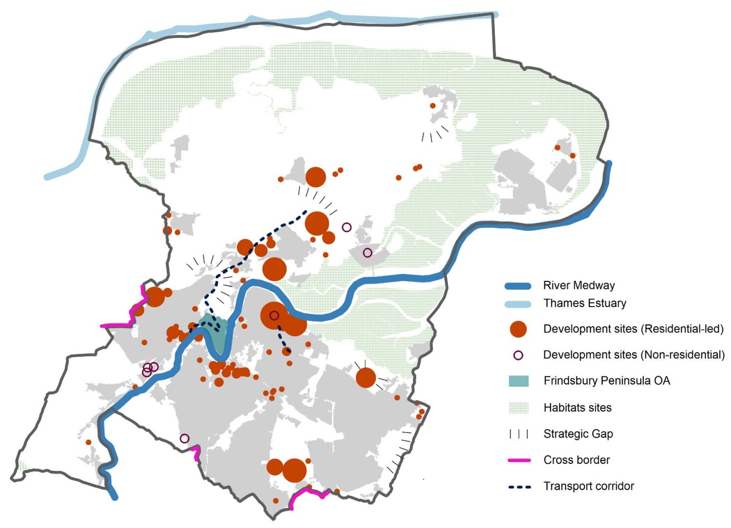
Figure 1: Key Diagram View responses
3.1.8 The Council has carried out a wide review of potential development land across the borough. This has been informed by the iterative Land Availability Assessment. The rural and suburban areas are considered to offer potential for development, and there has been strong promotion of sites by the private sector on greenfield sites in these locations. As Medway has a high level of housing need, the Council needs to consider large and strategic scale development allocations in the Local Plan to address the community's needs for homes, jobs and services. This heightens the sensitivity of potential greenfield allocations, as small urban, or village extensions, are not sufficient to provide for development needs. Larger developments will need to provide significant uplifts in services, such as new schools and health centres, and mitigate infrastructure constraints, including transport. Much of the undeveloped land adjacent to existing settlements in suburban and rural areas adjoins farmland of the best and most versatile quality. There are also large areas designated of international and national environmental importance. In considering potential development allocations in suburban and rural areas, the Council acknowledges the need to conserve and enhance the important habitats and landscapes, and to plan at an appropriate scale to support effective infrastructure delivery. In defining options, the Council has considered all potential locations, including land in the Metropolitan Green Belt. View responses
3.1.9 Land to the west of Strood (within the Green Belt) is an option investigated through duty to cooperate discussions with Gravesham BC, who had indicated the intention to allocate their adjacent Green Belt land parcels on Chapter Farm as a site allocation through preparation of their local plan. Medway's Green Belt review confirming most parcels as grey belt and considering the sustainability[1] of this location against the Local Plan strategy and through the Sustainability Appraisal, this location proves more sustainable and more in alignment with the Local Plan strategy. This provides a strong case for justifying exceptional circumstances for the release of land to the west of Strood. The Green Belt boundaries have therefore been amended accordingly with a few minor tweaks to ensure permanence of the Green Belt boundaries going into the future. View responses
3.1.10 In planning to meet the full scale of development needs in Medway over the plan period, there are complex issues to address, in securing a deliverable strategy for sustainable development. A range of mitigations will be required, including investment in transport improvements and wider infrastructure and services; protecting the natural and historic environment, addressing flood risk, and mitigation and adaptation to climate change. Further details are provided in the site allocation policies, informed by work on the evidence base and site assessments. View responses
Spatial Development Strategy View responses
The Council will support the implementation of a spatial strategy to deliver sustainable development in Medway up to 2041 that meets full provision for Medway's development needs. Development is supported where it demonstrates that it contributes to the conservation and enhancement of the natural and built environment, and the Council's ambitions for sustainable growth, set out in the strategic objectives in the plan.
The spatial development strategy supports the Council's commitment to achieve a net zero carbon Medway and to tackle the negative impacts of climate change through adaptation. These include reducing reliance on cars, reducing the need to travel and providing for sustainable travel choices, and strengthening blue and green infrastructure networks across Medway.
Medway has a high proportion of land designated of national or international importance for wildlife and landscape. These areas have the highest degree of protection from development, and the policies in this plan require their conservation and enhancement. A wider network of green and blue infrastructure across Medway seeks to connect countryside, parks and open spaces, and water bodies, to provide resilience for nature, secure landscape character, support health and wellbeing, and protect environmental resources. This green network informs the spatial strategy, separating urban Medway from the Hoo Peninsula and Kent Downs, and providing strategic green corridors in the urban and suburban areas. The plan seeks to deliver the multiple benefits of well designed green and blue infrastructure, particularly in urban areas where there is a deficit of high quality accessible greenspace. The Council will seek opportunities for development to address areas of poor environmental amenity, delivering Biodiversity Net Gain (BNG), supporting the implementation of the Kent and Medway Local Nature Recovery Strategy, improving air quality, and contributing to more attractive places, that are accessible to our communities to enjoy.
The development strategy for Medway prioritises regeneration, making the best use of previously developed land and directing investment to urban waterfront and centre opportunity areas. The rivers and estuaries will have a key role in the identity and function of Medway. This promotes Medway's ambitions to lift pride in the area, delivering quality development that respects our heritage, supports health and well-being and a resilient and attractive environment. The urban waterfront regeneration programme from Strood to north Gillingham will link to renewed centres and places. Development will be required to support improvements to active travel and green infrastructure, such as cycle paths, increasing canopy cover and sustainable urban drainage to deliver on the aims for Medway's communities and environment.
Chatham is an important focus for much of the urban regeneration, with development proposed in the centre of Chatham; and on waterfront sites, and in adjacent areas to the centre, such as Chatham Intra and the station gateway. The strategy is informed by the Chatham Design Code and the Chatham Intra Heritage Action Zone (HAZ) development framework to provide for new homes, workspaces, retail, leisure and community facilities. Chatham will provide the primary centre function for Medway, benefitting from its sustainable transport links and additional investment in cultural and community infrastructure.
Strood also provides for significant new opportunities for redevelopment alongside the riverside and central areas, and as a hub for sustainable transport. The completion of Rochester Riverside forms an important component of the wider waterfront regeneration programme. Redevelopment to the north of Gillingham will consolidate the links between St Mary's Island and Gillingham town centre, and support the further development of the learning cluster of Universities and Colleges, and strengthen the town centre. There are opportunities for further mixed-use urban neighbourhoods with the potential for redevelopment at Medway City Estate. The regeneration of the Frindsbury Peninsula will extend beyond the plan period and by 2050 will provide for mixed development, including new homes, green infrastructure, and a modern employment base. It will contribute to Medway's revitalised urban centre, with the river establishing place-making and nature-based solutions to managing flood risk.
The spatial strategy provides for a range of development needs, Growth in different parts of the urban, suburban and rural areas will reflect their distinctive character and identity, the potential for a mix of development, and the need for upgrades in infrastructure and services.
Outside of the urban regeneration areas, the Council will support the expansion of identified suburban neighbourhoods and villages, where the principles of sustainable development can be met, and where unacceptable impacts on infrastructure and the environment can be avoided. Large scale growth in these areas, including Hoo St Werburgh and Chattenden, Capstone Valley, West of Strood and Lower Rainham, will require strategic masterplans to manage and phase the delivery of housing, employment, transport and wider infrastructure, and environmental measures. On such greenfield sites, the Council will require a high standard of design quality and environmental sustainability to contribute to net zero carbon aims, reducing the need to travel and achieving a modal shift from car-based travel. Development will respond positively to the environmental context and realise opportunities to boost biodiversity and resilience.
The planned growth of Hoo St Werburgh as the principal settlement on the Hoo Peninsula will extend beyond the plan period into the 2040s. The vision is for a thriving community, supported by a good range of services, including retail, schools, health, sports and community facilities, where development has been successful in responding sensitively to the countryside and coastal setting and heritage informs the sense of place.
Exceptional circumstances justifies the release of Green Belt land to the west of Strood in collaboration with Gravesham BC to deliver a sustainable strategic cross border development. Minor amendments to the Green Belt boundaries in this location are also addressed to ensure permanence of the Green Belt into the future. The function of the remaining metropolitan Green Belt in Medway will be retained, and the Council will ensure that substantial weight is given to the potential for any harm when considering development proposals in the Green Belt.
Development will be required to demonstrate sensitivity to the rich and diverse built and natural heritage of Medway, to provide for quality growth and strengthen the distinctiveness and functions of local towns, neighbourhoods and villages.
The strategy provides for sustained economic growth, through providing a mixed portfolio of employment sites, supporting business growth and capitalising upon a skilled workforce, benefitting from the local Universities and Colleges. This portfolio includes strategic development sites on the Hoo Peninsula that have unique opportunities to support new and developing sectors, as the economy develops responses to environmental and industrial policies. Further employment sites will contribute to meeting the needs of businesses in Medway.
The strategy provides for the coordination of infrastructure delivery to support wider growth. Land is safeguarded for the delivery of a passenger rail service connecting the Hoo Peninsula to the North Kent services, and a sustainable travel link connecting Chatham Docks with Gillingham town centre, and transport hub in Strood. Development will be required to mitigate the impacts of its growth in line with the Council's policy on infrastructure contributions.
3.2 Policies Map
3.2.1 The Policies Map comprises five maps at the appropriate scale for the urban core, north west, north east, south west and south east areas of Medway. View responses
3.2.2 The Policies Map shows designations for the:
- site allocations;
- natural environment;
- economic development;
- built environment;
- retail and town centres;
- transport;
- minerals; and
- waste management.
3.2.3 An electronic version of the Policies Map can be viewed in any Portable Document Format reader.
[1] NPPF para 148, 110, 115