Medway Local Plan (Regulation 19, 2025)
14.1 Introduction
14.1.1 National planning policy requires local plans to set out an overall strategy for the pattern, scale and quality of development, making sufficient provision for housing (including affordable housing), employment, retail, leisure, commercial development, infrastructure, community facilities, and for the conservation and enhancement of the natural, built and historic environment. View responses
14.1.2 The site allocations set out where new development will be directed across Medway, in line with the spatial strategy. View responses
14.1.3 The site allocations are the product of the assessment of land availability and a site selection process. This has identified specific, deliverable sites for years one to five of the plan period and specific, developable sites or broad locations for growth for years six to 10 and, where possible, for years 11 to 15 of the plan period.
14.1.4 The housing trajectory, as part of the assessment of land availability, indicates the anticipated phasing of sites, however proposals on sites allocated for development are encouraged as soon as possible.
14.1.5 The site allocations have been organised by a geography which reflects the spatial strategy: View responses
- Chatham Town Centre and Surrounds
- Heritage-led Sites
- Gillingham Town Centre
- Gillingham Waterfront
- Strood Town Centre and Surrounds
- Strood West
- Capstone Valley
- Hoo St Werburgh and Chattenden
- High Halstow
- Lower Rainham
- Rural Settlements
- Other Sites
- Frindsbury Peninsula Opportunity Area
- Employment Sites
14.1.6 The site allocation policies set out the objectives, criteria and subsequent design principles to be addressed in a planning application. Some site allocations policies include a concept plan.
14.1.7 All planning applications for site allocations will be expected to include the following:
- Archaeological Statement
- Arboricultural Report
- Biodiversity Net Gain Calculations
- Heritage Impact Assessment
- Landscape and Visual Impact Assessment
- Flood Risk Assessment
This is not an exhaustive list; applicants are encouraged to seek early engagement through the pre-application service to determine the full suite of documents to support a planning application. View responses
14.1.8 To avoid duplication, it is important to note that all strategic, thematic and development management planning policies in this Local Plan apply to the site allocation policies. View responses
14.1.9 The site allocation policies should also be read in conjunction with the latest Infrastructure Delivery Plan.
14.1.10 Each site can be identified by its unique reference, i.e. AS2 to W7, as shown on the Policies Map itself.
14.2 Chatham Town Centre and Surrounds
14.2.1 The Local Plan strategy optimises growth on brownfield land, which makes up approximately 40% of the planned growth in Medway. Sites in centres contribute toward this. Centre locations offer existing infrastructure networks, services and facilities, which can be relied and expanded upon to support sustainable living. Regeneration of Medways centres including its main centre, Chatham, will ensure ambitions of sustainable growth and sustainable living is achieved by providing in-centre and edge of centre housing and supported by the necessary infrastructure.
14.2.2 The Chatham Design code (2024) and Chatham masterplan (2019) play key roles in delivering quality development, whilst identifying sites appropriate for housing provision. The sites listed below fall within and on the edge of Chatham and will contribute toward delivery of the Local Plan strategy. Sites are identified through the Chatham Design Code and Regeneration programmes at Medway Council, which demonstrates commitmment and provides a level of certainty for delivery.
Policy SA1: Chatham Town Centre and Surrounds View responses
Objective
- In delivering on its residential potential, opportunity sites within Chatham Town Centre can also provide a mix of uses, public realm improvements and more to support sustainable in-centre living, shopping and working. Development will be guided by the following:
Criteria
- Total site area: 11.78ha
- Collectively these identified small to medium sized sites will deliver circa 1,350 new homes predominantly within the early part of the plan period.
- The redevelopment of these brownfield, underused and vacant sites will be encouraged where in accordance with other relevant policies in this Local Plan and principles within the Chatham Design Code (2024) and the Chatham Town Centre Masterplan (2019).
- Housing mix and Affordable Housing provision will be provided in accordance with policies T2 and T3 respectively. As part of the wider housing strategy, the provision of supported housing, students, older persons and specialist needs will be supported where considered appropriate.
- Mixed use schemes with active frontages within the centre will be supported, particularly along the high street to continue to encourage positive footfall into the centre and support in-centre working and living.
- Proposals should, in demonstrating compliance with policy S1, explore the potential to re-use or renovate existing buildings rather than demolishing and rebuilding them, to minimise embodied carbon emissions.
- Proposals must demonstrate appropriate mitigations and adaptations to the risk of flooding.
- Ensure air quality is appropriately addressed through the proposal design particularly in the identified Air Quality Management Area (AQMA).
- Ensure proposals are informed by appropriate scoped heritage, landscape and townscape assessments.
- Site FP10 is within the setting of scheduled monuments and must demonstrate its contribution to heritage significance.
- Site FP25 has an opportunity to reveal much about the history of Chatham through sensitive design. The scale of development will need to be carefully and sensitively considered to avoid impacting upon designated heritage and listed buildings.
- Contribute toward the provision of green-blue infrastructure and suitable walking and cycling links to improve accessibility, health and well-being objectives.
Subsequent design principles
- Demonstrate consideration of the historic environment and the townscape by submitting with a planning application, a:
- Views analysis
landscape and townscape assessments that has been used to inform the design of the scheme
- Site FP25 must be supported by a masterplan alongside a planning application
- Sites CCB49 and GS2 must provide a Heritage, Townscape and Visual Impact Assessment alongside a planning application
- Flood Risk Assessment
Site-specific information
|
Policies Map ID |
Name |
Land uses |
Number of new homes and/or floorspace within plan period |
Plan period (Years) |
|
CCB1 |
Avenue Business Centre, 17 New Road Avenue, Chatham |
Residential |
Circa 12 |
1-5, 6-10 |
|
CCB3 |
Cambridge House, 1 Cambridge Terrace, Chatham |
Residential |
Circa 13 |
1-5 |
|
CCB4 |
3 New Road Chatham |
Residential |
Circa 50 |
1-5 |
|
CCB7 |
153-155 High Street, Chatham |
Residential |
Circa 9 |
1-5 |
|
CCB8 |
Mountbatten House, 28 Military Road, Chatham |
Residential |
Circa 164 |
1-5 |
|
CCB12 |
Land bounded by Richard Street, Clove Street and James Street, Chatham |
Residential |
Circa 24 |
1-5 |
|
CCB15 |
Former Debenhams, Chatham |
Residential |
Circa 60 |
1-5, 6-10 |
|
CCB19 |
1-3 Rhode Street, Chatham |
Residential |
Circa 13 |
1-5 |
|
CCB20 |
Former Trafalgar Centre and Multi Storey Car Park, High Street, Chatham |
Residential |
Circa 98 |
1-5 |
|
CCB21 |
263-269 High Street, Chatham |
Residential |
Circa 14 |
1-5 |
|
CCB24 |
287-289 High Street Chatham |
Residential |
Circa 9 |
1-5 |
|
CCB27 |
R/O 295-299 High Street fronting The Brook, Chatham |
Residential |
Circa 20 |
1-5 |
|
CCB30 |
13-17 Church Street, Chatham |
Residential |
Circa 21 |
1-5 |
|
CCB31 |
Land bounded by the Brook Car Park, Queen Street, Chatham |
Residential |
Circa 179 |
1-5 |
|
CCB37 |
Former Go Outdoors, Chatham |
Residential |
Circa 200 |
1-5, 6-10 |
|
CCB39 |
389-391 High Street, Chatham |
Residential |
Circa 24 |
1-5 |
|
CCB41 |
5 Otway Terrace, Chatham |
Residential |
Circa 7 |
1-5 |
|
CCB49 |
Telephone Exchange, Best Street, Chatham |
Residential |
Circa 150 |
1-5, 6-10 |
|
FP10 |
Former St John Fisher School |
Residential |
Circa 139 |
1-5 |
|
FP25 |
Chatham Rail Station area |
Residential |
Circa 121 |
1-5, 6-10 |
|
GS2 |
Samuels Towers, Longhill Avenue, Chatham |
Residential |
Circa 45 |
1-5, 6-10 |
|
L7 |
272-274 Luton Road, Chatham |
Residential |
Circa 6 |
1-5 |
|
L9 |
352-356 Luton Road, Luton |
Residential |
Circa 22 |
1-5 |
|
L12 |
101 Beacon Road, Chatham |
Residential |
Circa 13 |
1-5 |
14.3 Heritage-led Sites
14.3.1 Development on the Interface Land is guided by the Chatham Interface Land Supplementary Planning Document (2018). Medway Council has more recently adopted a Star Hill to Sun Pier Development Framework (2024), which received funding for the Heritage Action Zone.
14.3.2 The Interface Land SPD remains relevant and provides flexibility to respond to the market. As such, the opportunity to deliver housing as part of mixed-use schemes should be explored. Proposals will need to ensure that all relevant bodies are consulted to ensure appropriateness in this location.
14.3.3 The Star Hill to Sun Pier Development Framework provides appropriate guidance within a conservation area and is supported by Historic England. This guidance also plays a key role in linking two of Medway's historic centres, Rochester and Chatham, calling for the celebration of Medway's heritage. The southern end of this defined area together with the Chatham Design Code provides a seamless transition into Chatham, which also seeks to enhance the waterfront area, activate space and create an environment suitable to support a sustainable and desirable quality of life for future and current residents.
Policy SA2: Heritage-led Sites View responses
Objective
- Medway is rich in heritage and prides itself in protecting, celebrating and enhancing this. Two strategic heritage led site allocations will provide an opportunity to sensitively deliver on housing targets whilst respecting its heritage context, i.e. Interface land and Star Hill to Sun Pier. Development proposals will be guided by the following:
Criteria
- Interface Land:
- Combined site areas: 5.3 ha
- Combined site capacity: Circa 150 new homes as part of a mixed use development
- Both sites are within the setting of a number of scheduled monuments and Dockyard buildings and also contain undesignated archaeology. Mixed use schemes must respond positively to the historic and locational context and be compliant with the Interface Land Supplementary Planning document (SPD)
- Development will need to be compliant with relevant Local Plan policies including but not limited to heritage DM10 and S8, housing mix T2, affordable housing T3, design T1, DM5, DM6 and S14
- Development should seek to reinforce the historic character of the northern end of the Dockyard, currently the focus of timber management associated with the construction of ships.
- Star hill to Sunpier:
- Combined site areas: 3.68 ha
- Combined site capacity: circa 474 new homes
- Development will need to be compliant with the Star Hill to Sun Pier Development Framework, relevant Conservation Area Appraisal and Management plan and relevant Local Plan policies including but not limited to S9, S8, DM10.
- The historic setting and context will be appropriately addressed:
- Proposals on site FP1 should seek to retain and reuse existing historic buildings and where possible reinforce and reveal areas of now lost historic landscape.
- Development on site FP11 should reinforce and reveal the special historic character of the conservation area, avoiding taller and bulky built forms.
- Proposals should, in demonstrating compliance with policy S1, explore the potential to re-use or renovate existing buildings rather than demolishing and rebuilding them, to minimise embodied carbon emissions.
Subsequent design principles
- Archaeological desk-based assessment and evaluation will be required where necessary to inform detailed proposals alongside planning applications.
- Compliance with Interface Land SPD
- Compliance with relevant Conservation Area Appraisals and Management Plans
- Compliance with Star Hill to Sun Pier Development Framework
Site-specific information
|
Policies Map ID |
Name |
Land uses |
Number of new homes and/or floorspace within plan period |
Plan period (Years) |
|
CCB25 |
Riverside (Interface Land) |
Residential |
circa 150 |
6-10 |
|
CCB35 |
Brunel (Interface Land) |
Mixed-use |
0 |
11-15 |
|
FP1 |
320-346 High Street Rochester |
Residential |
circa 28 |
6-10 |
|
FP11 |
Grays Garage, High Street, Chatham |
Residential |
circa 123 |
1-5 |
|
FP12 |
6-11 New Road Avenue, Rochester |
Residential |
circa 70 |
1-5, 6-10 |
|
FP14 |
73 High Street, Chatham |
Residential |
circa 7 |
1-5 |
|
FP16 |
First floor, 74 High Street, Chatham |
Residential |
circa 6 |
1-5 |
|
RWB19 |
Bardell Terrace, Rochester |
Residential |
circa 246 |
1-5 |
14.4 Gillingham District Centre
14.4.1 The Local Plan strategy optimises growth on brownfield land, which makes up approximately 40% of the planned growth in Medway. Sites in centres contribute toward this. Centre locations offer existing services, facilities and infrastructure networks, which can be relied upon and expanded. The regeneration of Gillingham District Centre will ensure ambitions of sustainable growth and sustainable living is achieved by providing in-centre and edge of centre housing and supported by the necessary infrastructure.
14.4.2 This policy ambition should be read alongside policy SA4, which seeks to deliver a river walkway and green link to the district centre. Students and residents will have greater accessibility to the waterfront and travel to university and shopping/leisure along the river will be sustainably accessed. Health objectives will also be supported and provide for a much needed greenery beyond the dense communities of Gillingham.
Policy SA3: Gillingham District Centre View responses
Objective
- Infill development in Gillingham District Centre will support sustainable growth objectives. Development proposals will be guided by the following:
Criteria
- Site area: 0.465 ha
- Will deliver circa 100 new homes within the first 5 years of the plan period
- Proposals will demonstrate compliance with the Gillingham masterplan 2019 or more up to date guidance where relevant
- The small infill developments must be developed in accordance with the relevant Local Plan policies
- Mixed use schemes will be supported where active frontages encourage footfall, support the vitality and vibrancy of the centre and encourages centre living.
- Student accommodation and facilities would be supported due to its proximity to universities
- Proposals should, in demonstrating compliance with policy S1, explore the potential to re-use or renovate existing buildings rather than demolishing and rebuilding them, to minimise embodied carbon emissions.
- Opportunities must be sought to connect walking and cycle routes to connect to destinations including universities and with the proposed Gillingham Greenway as a rich green resource for residents to improve health and connectivity to the waterfront and riverside walk.
Subsequent design principles
- Demonstrate compliance with relevant guidance
Site-specific information
|
Policies Map ID |
Name |
Land uses |
Number of new homes and/or floorspace within plan period |
Plan period (Years) |
|
GS4 |
4 Fox Street and 5-7 Mill Road, Gillingham |
Residential |
Circa 24 |
1-5 |
|
GS7 |
Former nightclub 22-32 Canterbury Street, Gillingham |
Residential |
Circa 14 |
1-5 |
|
GS14 |
105-107 High Street, Gillingham |
Residential |
Circa 6 |
1-5 |
|
GS19 |
Former snooker hall, 48 Green Street, Gillingham |
Residential |
Circa 57 |
1-5 |
|
GS26 |
82 Jeffery Street, Gillingham |
Residential |
Circa 14 |
1-5 |
14.5 River Waterfront
14.5.1 Due to the meandering of the River Medway, Medway benefits from a significant proportion of waterfront. Largely, efforts through negotiations with developers have secured stretches of riverside walkways. However, there are some breaks where opportunity has not presented itself. These sites along this stretch of the River Medway (between St Marys Island and the Strand) presents an opportunity to knit the existing walkways together, providing a comprehensive walkway from the Strand, along the waters edge, through to the Chatham Dockyard. A slight deviation through the Dockyard and long Dock Road, takes you back onto the River Medway walk past the Council offices and through to Rochester riverside. View responses
14.5.2 Improving the health of the Medway's residents is one of the key objectives of the Local Plan strategy. Providing greater access to the waterfront by means of a walkway, will support healthy habits but also encourage sustainable movements between centres. The proposed Greenway from the Peel Ports site (SM16) through to Gillingham District Centre via use of the disused tram link is an opportunity to further support the health objectives and a sustainable, safe and accessible route down to the waterfront. There are also other more natural routes that can be facilitated by connecting existing green spaces south of Pier Road that lead to the waterfront. This will revitalise the Gillingham Edge and integrate communities. This will also support students access services and facilities within Gillingham District Centre and travel to and from university. View responses
14.5.3 The improvement of waterfront accessibility close to the North Kent Marshes designated sites (and areas of Functionally Linked Land) has the potential to increase recreational pressure and disturbance for species using these areas. There is also the potential for impacts associated with lighting of new routes / developments (urbanisation effects). View responses
14.5.4 Height of built form in this location is varied and more recent build outs have pushed heights. Whilst this may have been appropriate for particular sites, the decision making has been informed with a careful eye on the skyline and its potential impact on the surrounding areas near and far, within view. Proposals will need to give due consideration to the views in and out of the site as well as impacts on neighbouring uses.
14.5.5 The urban environment, current and historic land uses along the rivers edge do not provide much green infrastructure. The result is a hard, uninviting environment. These development sites present the opportunity to soften the environment. The concept plan shows the ambition of doing this, which starts with a softening of the site Pier Road edge and blending through the development sites through to the walkway at the river's edge.
14.5.6 Gillingham Marina will need to address the potential of flooding, which could include a flood defence wall. Land reclamation is also proposed to ensure a bigger footprint is available to build out a viable scheme.
14.5.7 The gas holder site does have land contamination issues that will need to be addressed to ensure development is safe but also to enable access arrangements are secured in the appropriate locations where required.
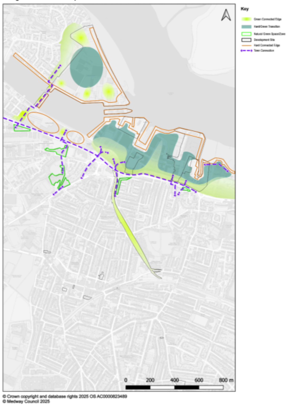
Figure 11: River Waterfront Concept Plan
Policy SA4: River Waterfront View responses
Objective
- Development will deliver greater accessibility for residents to the waterfront through increased permeability and connectivity between the sites and the surrounding area. This will take the form of a strong greenway link to Gillingham District centre and a riverside walk connecting St Marys island to the Strand, which is the missing link to provide a comprehensive riverside walk to the rest of Medway. In doing so, development will strongly be supporting health, accessibility, amenity objectives and improving quality environments for future residents and existing.
Criteria
- Development proposals will deliver up to 4,197 new homes:
- The mix of housing will be provided in line with Housing Policy T2 and T3, reflecting the communities' needs as evidenced in the Medway Local Housing Needs Assessment, 2025.
- Within the wider housing strategy, the Council would require this scale of growth to meet a wide range of housing needs, including specialist provision for older people (policy T4) and student accommodation (policy T5).
- Accommodation for older people could be complimented by accessible services and facilities including convenience retail where justified and the required sequential and impact tests are satisfied.
- Proposals should, in demonstrating compliance with policy S1, explore the potential to re-use or renovate existing buildings rather than demolishing and rebuilding them, to minimise embodied carbon emissions.
- Any enhancement in waterfront accessibility will have no adverse impact upon the integrity of the North Kent Marshes designations (and Functionally Linked Land), either alone or in-combination.
- The waterfront sites sit in a very hard, urban context with little green infrastructure particularly along the rivers edge. The development sites present an opportunity, as a transition zone, to bring in green infrastructure from north of Pier Road and blending in between the built form of proposals toward the rivers edge. This will help reverse the potentially unwelcoming riverside façade and enable the provision of an attractive riverside walk.
- Building heights must be assessed as part of a composed skyline that works with local and distant relationships:
- Proposed building heights shall positively respond and relate to the existing built form in immediate and close proximity to the site and visibility from natural landscapes from a distance like Riverside Country Park and Cockham Community Parkland.
- The height of development on site GN6 must not be overbearing in relation to the neighbouring Strand. Its relationship with the Strand should be more gentle without adversely impacting on the Strands' amenity.
- A Green-blue infrastructure strategy will inform place-making and the design and layout of proposals:
- Development will respond to its setting by addressing the inadequate provision of green space. Proposals will be required to soften the location with amenity space, landscape and public realm treatments, extending from Pier Road and between built form through to the rivers edge.
- Delivery of the Gillingham Greenway will connect the new growth allocation to Gillingham District Centre, supporting access to the riverside, sustainability and healthier lifestyles.
- SM16 should maximise the opportunity to provide a generous amount of high quality, publicly accessible green infrastructure as a resource for the public to enjoy as part of the riverside walk.
- The urban context will not provide for adequate space to meet all the requirements for open space and playing pitch provision in line with the Field in Trust standards.
- Amenity space, equipped and informal play will be provided in accordance with policy DM21
- Provision of natural and semi-natural green space could be provided off-site or as enhancements to the Strand and/or Riverside Country Park.
- financial contribution will be sought for the provision or enhancement of outdoor sports provision
- Connections will aim to bring the developments together to create a natural continuity between the west (St Mary's Island) and the east (The Strand), as well as between the north (Waterfront) and the south (Town / local communities)
- Proposals will work together to create far reaching links, bringing pedestrians and movements towards the rivers edge as well as joining the areas along the riverside.
- The Gillingham Greenway will provide the main substantial link to the wider Gillingham area alongside a network of natural routes as set out in the concept plan. The foundation of the network of routes currently exist and will require enhancements.
- A network of safe, attractive connections to key destinations will ensure well used routes and support sustainability and health objectives.
- The rivers edge is a manmade frontage with an inadequate provision of green infrastructure or natural features that could assist in flood mitigation.
- Delivery of the scale of housing on GN15 will require land reclamation, enabling the reconfiguration of the boat moorings. This will create opportunities to enhance ecological sustainability in the area.
- Flood mitigation and/or a flood defence wall will be required to enable delivery
- Issues on contamination on GN6 will require remediation to ensure safe, accessible and healthy development.
- The underground infrastructure will also need to be addressed to ensure ease of access and optimisation of the site for development. The current placement of gas pipes could have implications for the layout and placement of buildings.
- The design and layout of streets will follow a legible hierarchy that maximise opportunities for pedestrian and cycling.
- Main accesses will be taken off Pier Road for all sites.
- Provision for emergency accesses must be addressed to ensure the sites are serviceable.
- All sites should be sustainably accessed and demonstrate a 10% modal shift
- Proposals shall explore alternative parking solutions to more sustainable transport options including bus stops, tram links, cycle hubs, walk ways, uber/taxi hubs and other transit initiatives.
- In addition to the walkway along the riverfront, developments will need to demonstrate high degrees of permeability through segregated walking and cycle ways connecting to other key destinations and other.
- Site SM16 presents an opportunity for heritage led regeneration that draws on the sites history as an important anchor in the Dockyards later development, while simultaneously offering a great opportunity to support large scale growth.
- A development brief based on a thorough understanding of the site's heritage and its setting would help de-risk future development and allow for the proper planning of new development that is sympathetic to Medway's historic environment as a whole.
Subsequent design principles
- The applicants for sites GN6, GN15 and SMI6 will collaborate to produce a masterplan, to be approved by Medway Council, to guide subsequent planning applications and further approval of details.
- A comprehensive approach to site development will be expected, informed by an approved master plan, which demonstrates how the policy and infrastructure requirements set out in the respective plans relating to the site as whole, with a phasing plan, will be achieved.
- Preparation of an infrastructure delivery plan / phasing plan
- Development shall be phased broadly instep with infrastructure delivery plan and phasing plan
- Any application for development on part of the site shall accord with the adopted master plan and shall not prejudice the implementation of the site as a whole.
- Delivery will be secured through a legal agreement.
- S106 – provision of financial contributions towards the provision of infrastructure, including additional primary and secondary school places in accordance with the latest IDP
- Potential funding from Homes England could support:
- land reclamation
- Flood defence wall
- Address contamination
- Address underground infrastructure
- Delivery of the Green Greenway connecting the waterfront to Gillingham District council
Site-specific information
|
Policies Map ID |
Name |
Land uses |
Number of new homes and/or floorspace within plan period |
Plan period (Years) |
|
GN3 |
Pier Approach, Road Depot |
Residential |
Up to 176 |
6-10 |
|
GN6 |
Former gas works site, north of Pier Road, Gillingham |
Residential Older persons accommodation Convenience retail |
Up to 500 |
1-5 |
|
GN15 |
Gillingham Marina |
Residential |
Up to 1,100 |
1-5, 6-10, 11-15 |
|
SMI6 |
Chatham Waters |
Residential |
Up to 2,200 |
1-5, 6-10, 11-15, 15+ |
14.6 Strood Town Centre and Surrounds
14.6.1 The Local Plan strategy optimises growth on brownfield land, which makes up approximately 40% of the planned growth in Medway. Sites in centres contributes toward this. Centre locations offer existing infrastructure networks, which can be expanded upon. The regeneration of Strood District Centre will ensure ambitions of sustainable growth and sustainable living is achieved by providing a transport hub, in-centre and edge of centre housing and supported by the necessary infrastructure.
14.6.2 The Strood Waterfront Development Framework is being revisited and will provide a framework which will provide guidance for planning applications.
Policy SA5: Strood Town Centre and Surrounds View responses
Objective
- Strood District Centre will undergo significant change. Delivery of a robust transport interchange alongside significant new growth will support it becoming an attractive and highly accessible destination of choice for living, working and enjoying. Development will be guided by the following:
Criteria
- Site area: 21.17ha
- Identified sites will deliver circa 1,079 new homes
- Development proposals shall demonstrate compliance with relevant Local Plan policies, The Strood Waterfront Development Brief (2018) and the Strood Town centre masterplan 2019 and/or updated guidance where relevant
- Proposals should, in demonstrating compliance with policy S1, explore the potential to re-use or renovate existing buildings rather than demolishing and rebuilding them, to minimise embodied carbon emissions.
- A transport interchange will be provided:
- This will provide a destination for a Bus Rapid Transit corridor connection with Hoo St Werburgh ensuring wider accessibility to communities and supporting sustainable movements.
- Sites within or adjacent to the centre should be explored to provide the transport interchange
- Will be supported by a network of pedestrian and cycle links and supported by a frequent and reliable bus service
- Greater accessibility to London Victoria services will be achieved by delivering improvements to Strood rail station by way of new platforms and improved pedestrian access.
- SNF41 will include a commercial use within the residential led scheme to support the rail station.
- The increase in housing provision will require an expanded/improved/new Healthy living centre at SNF20
- Clustered together (SNF9, SNF15, SNF17), these sites represent a significant mixed use redevelopment opportunity for Strood Town Centre that could reinforce and reveal its historic townscape and deliver on housing, retail and commercial requirements. Proposals must be supported by a comprehensive masterplan.
- SNF34 combined with the Council owned civic site (SNF35), a prominent riverside site, be deliver a residential-led scheme
- The provision of appropriate supporting commercial uses including leisure and food/drink opportunities to enliven street/riverside frontages and public spaces will be supported.
- it has the opportunity to respectfully and sensitively address Rochester Castle and its setting in delivering a reimagined entrance into Strood District Centre. It is essential that proposals demonstrate an understanding of the historic significance of the site and its surrounding and be supported by a views analysis.
- Will ensure flood risk is appropriately mitigated and managed to support development
- The provision of usable open space will be optimised where possible to support a healthier, sustainable and attractive environment for communities to enjoy living in.
Subsequent design principles
- The applicants for sites SNF9, SNF15, SNF17, SNF34, SNF35 and SNF41 will collaborate to produce a masterplan, to be approved by Medway Council, to guide subsequent planning applications and further approval of details.
- £75k has been secured from Homes England for Strood Riverside. This has funded a transport study to inform the local infrastructure improvements required and a masterplan. A detailed design of the transport interchange will be required and informed by the masterplan.
- S106 contributions will be sought toward the delivery of infrastructure
- A Green infrastructure strategy and open space strategy will support a planning application.
- The Transport interchange will need to be supported by an access strategy alongside a planning application.
Site-specific information
|
Policies Map ID |
Name |
Land uses |
Number of new homes and/or floorspace within plan period |
Plan period (Years) |
|
SNF5 |
Land at 18 Broom Hill Road, Strood |
Residential |
Circa 8 |
1-5 |
|
SNF8 |
North Side, Priory Road |
Residential |
Circa 19 |
1-5 |
|
SNF9 |
North-west of Cuxton Road, Strood |
Residential |
Circa 40 |
1-5, 6-10 |
|
SNF15 |
Land surrounding Tesco, Strood |
Residential |
Circa 350 |
6-10 |
|
SNF17 |
161-163 High Street, Strood |
Residential |
Circa 6 |
1-5 |
|
SNF20 |
Medical Centre, North of Gun Lane, Strood |
Residential |
Circa 15 |
1-5 |
|
SNF23 |
100-110 High Street, Strood |
Residential |
Circa 8 |
1-5 |
|
SNF24 |
13-17 North Street Strood |
Residential |
Circa 7 |
1-5 |
|
SNF27 |
24 Gun Lane Strood |
Residential |
Circa 13 |
1-5 |
|
SNF30 |
75-81 High Street, Strood |
Residential |
Circa 9 |
1-5 |
|
SNF31 |
70-76 High Street, Strood |
Residential |
Circa 8 |
1-5 |
|
SNF32 |
22 & 24 St Marys Road Strood |
Residential |
Circa 6 |
1-5 |
|
SNF34 |
Texaco, 23-37 High Street, Strood |
Residential |
Circa 52 |
1-5, 6-10 |
|
SNF35 |
Civic Centre, Strood |
Residential |
Circa 171 |
6-10 |
|
SNF38 |
1-7 Canal Road, Strood |
Residential |
Circa 12 |
1-5 |
|
SNF41 |
Strood Riverside |
Residential |
Circa 216 |
6-10 |
|
SNF44 |
Garden Service Station, Frindsbury Hill |
Residential |
Circa 6 |
1-5 |
|
SR25 |
West of Parsonage Lane, Frindsbury |
Residential |
Circa 152 |
1-5 |
|
SW6 |
178 Darnley Road, Strood |
Residential |
Circa 8 |
1-5 |
|
SW7 |
Land adjacent to 2 & 4 Laburnum Road, Strood |
Residential |
Circa 6 |
1-5 |
14.7 Strood West
14.7.1 Through duty to cooperate discussions, Gravesham BC has confirmed its intentions to bring forward Chapter Farm as a development allocation in its Local Plan strategy. Releasing Green Belt in this location would have knock on impacts for the remaining Green Belt in Medway. The adjacent Medway Green Belt land in this location would not be performing the Green Belt function once land was developed in the Gravesham Green Belt area. Medway's Green Belt Review confirms most parcels as grey belt and considers the sustainability of this location and better alignment with the Local Plan strategy significant enough to satisfy exceptional circumstances to release parts of this site that sits in the Green Belt. View responses
14.7.2 Medway Council is working collaboratively with Gravesham Borough Council to explore the opportunity of this location (south of the A289) recognising the potential it has to bring forward sustainable growth, and in doing so offers a comprehensive scheme that can deliver on key required infrastructure rather than piecemeal developments with limited infrastructure. View responses
14.7.3 Part of the site that sits in Gravesham is to the west of Gravesend Road, referred to as Chapter Farm. The majority of Medway's land (Strood West) sits to the east of Gravesend Road with a portion south of the Gravesham parcels. View responses
14.7.4 This location is between the urban fringe of Strood and the countryside and within the M2 and A289 corridors, offering the prospect of achieving sustainability ambitions. It is therefore not just an extension of Strood but a transition between the built-up area of Strood leading into the countryside. The scale and density of housing and development will need to be appropriate and supported by green infrastructure that reflects the character of the area and its setting. As such, the approach will need to be landscape led and heavily informed by views analysis. View responses
14.7.5 Both authorities have commissioned a high-level masterplan to inform the framework of the policy and ensure the bespoke response is appropriately articulated. The policy below sets out the key considerations that will need to be taken into consideration, verified by discussions with statutory bodies and stakeholders and informed by evidence prepared by both authorities. It is expected however that developers will be required to undertake detailed assessments to further inform development proposals. View responses
14.7.6 In summary the location requires an approach that can deliver on the required infrastructure of schools, a centre/community hub, mobility hub and employment uses that are sustainably accessed. It must respond positively to heritage, topography, landscape and view sensitivities. View responses
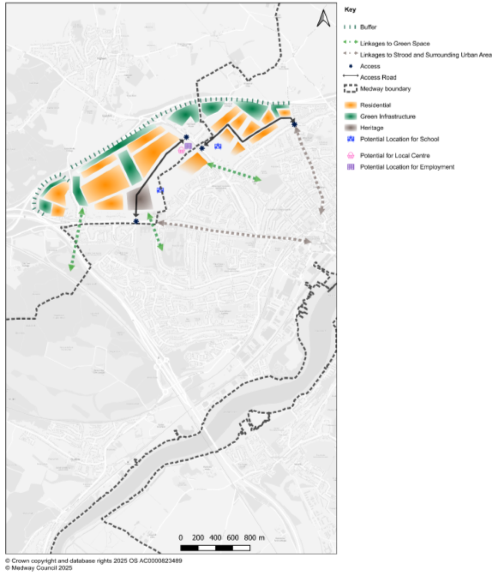
Figure 12: Land West of Strood Concept Plan View responses
Policy SA6: Land West of Strood View responses
Objective
- Land West of Strood together with Chapter Farm (Gravesham Borough Council), will provide a comprehensive cross border sustainable location for growth, which transitions between the urban edge of Strood and the Green Belt and maintains the identity of the rural settlement of Three Crutches.
- Medway Council will work collaboratively with Gravesham Borough Council to deliver this strategic cross border Green Belt site providing up to 4,000 new homes, two primary schools, an expansion of an existing primary school, a secondary school, 2 hectares of employment and a local centre , 2 football pitches and indoor sports provision.
Criteria
- Will deliver up to 1,280 new Medway homes within the plan period:
- The housing density must reflect the transition from urban to countryside ensuring densities are gradually lowered toward the countryside edges
- The housing mix must be in compliance with The Local Housing Need Assessment and policy T2 in providing for the needs of the community.
- Affordable Housing will be provided in accordance with the Golden Rules.
- Proposals shall demonstrate a landscape led approach, which takes account of:
- The countryside context, key landscape characteristics, views, the significance of heritage assets and the setting of the Kent Downs National Landscape.
- The landscaping will be planted at an early stage of the development and provide new habitats for priority nature conservation species and be appropriate to landscape character.
- a substantial buffer along the A289 is provided to enhance the transition into the Green Belt and provide a noise mitigation.
- A Green-blue infrastructure strategy will shape placemaking by supporting the design and layout of proposals:
- The development design will respond to its countryside setting, the landscape and topography
- Maximise opportunities for provision of high quality and publicly accessible multi-functional green-blue infrastructure, biodiversity enhancements and SuDS
- It will deliver on:
- environmental gains Biodiversity Net Gain (10% minimum)
- and ecological enhancements in line with the Local Nature Recovery Strategy priorities.
- The design and layout of streets will follow a legible hierarchy for maximum bus accessibility and pedestrian movement:
- The primary access points will be taken off Gravesend Road, the A2 (Watling Street) and Stone Horse Lane to provide the main through routes.
- Multi-modal access will be facilitated by lower order roads
- Old Watling Street, Crutches Lane and Strodes Close will be improved to support walking and cycling access
- Proposals will encourage sustainable habits and ensure a strong sense of place by delivering a connected development informed by a strategic access strategy, which will:
- prioritise active travel, well designed parking solutions and multi-modal access into and out of the site supported by an integrated public transport and cycle/mobility hub with a reliable and frequent bus service and cycle/mobility hub
- Opportunities to establish a reliable and frequent bus service must include the exploration of Fast Track to serve the area west of Gravesend Road.
- explore the opportunity to widen and segregate cycle route NC177 in the provision of a walking and cycling network
- provide attractive walking and cycling links between the existing Strood District Centre, the new development and the surrounding countryside including linkages with NNRs and LNRs, other destinations and points of interest.
- Proposals for the area to the west of Gravesend Road shall have regard for the heritage significance of Chapter Farm and its setting. Proposals shall ensure that the historic administrative boundary is protected and enhanced.
- The co-location of uses will provide an attractive location for investment and support convenience, accessibility and sustainability.
- Provision of a local centre is preferred centrally on the western side of Gravesend Road. This centre will include convenience retail to meet the day to day needs of residents, complementary retail and community uses (use classes Eb-Ef, F2) and an active travel cycle/mobility hub.
- 2 hectares of employment provision co-located with the centre on the western side of Gravesend Road, providing flexibility to accommodate commercial uses serving the local community (use Classes Eb-Eg, F2).
- Provision must be of appropriate scale, format and type that is sensitive to the countryside location and provides an appropriate response to the setting of the Kent Downs National Landscape.
- Development will be set within green infrastructure and appropriate connections through segregated walking and cycling routes, bus linkages.
- The development will provide for new education facilities in accordance with the latest IDP:
- two two-form entry primary schools
- An expansion of one-form entry to Temple Hill Primary school
- an eight-form entry secondary school
Consideration will be given to efficient use of land in the delivery of an all-through school, which would include a three-form entry primary school plus an eight-form entry secondary school.
- New open space and playing pitches will be provided in accordance with the Fields in Trust (FIT) standards as set out in policy DM21. Allotment provision will be required at a standard of 0.25ha/1000 people.
- The development will incorporate publicly accessible, well-managed and high quality open spaces, which are linked to the open countryside and adjoining settlements.
- Provision will include two football pitches (one of which must be 3G) with associated changing room facilities, which can be co-located with the education infrastructure.
- Proposals will provide a replacement indoor sports facility.
- There is an opportunity to co-locate or include the sports pitches and indoor sports facility within the schools. A Community Use Agreement with a new Primary or Secondary schools would help to ensure access to sports infrastructure and a more efficient use of land.
Subsequent design principles
- The applicants for sites SNF1, SNF3 and SR5 will collaborate to produce a landscape-led masterplan, to be approved by Medway Council and Gravesham Borough Council to guide subsequent planning applications and further approval of details.
- A comprehensive approach to site development will be expected, informed by an approved master plan, which demonstrates how the policy and infrastructure requirements set out in the respective plans relating to the site as whole, with a phasing plan, will be achieved.
- Preparation of an infrastructure delivery plan / phasing plan
- Development shall be phased broadly instep with infrastructure delivery plan and phasing plan
- Any application for development on part of the site shall accord with the approved masterplan and shall not prejudice the implementation of the site as a whole.
- Delivery will be secured through a legal agreement.
- S106 – provision of financial contributions towards the provision of infrastructure, including additional primary and secondary school places in accordance with the latest IDP.
- An access strategy must be informed by audits into Strood District Centre and other destination points like supermarkets etc..
Site-specific information
|
Policies Map ID |
Name |
Land uses |
Number of new homes and/or floorspace within plan period |
Plan period (Years) |
|
SNF1 |
Land west of A226 Gravesend Road and north of Brompton Farm Road |
Residential with opportunity for other TBD |
Up to 360 |
1-5, 6-10 |
|
SNF3 |
Land bounded by Dillywood Lane, A226 Gravesend Road and Brompton Farm Road |
Residential Other TBD |
Up to 800 |
1-5, 6-10, 11-15 |
|
SR5 |
Land west of Stonehorse Lane |
Residential |
Up to 120 |
1-5 |
14.8 Capstone Valley
14.8.1 The Capstone Valley forms a steep- sided dry valley, consistent in landscape character to the Kent Downs National Landscape, which was the target for the original designation of the Kent Downs. It also forms part of a valued countryside gap between existing built-up areas that flows into the Kent Downs to the south. View responses
14.8.2 Much of the land in the Capstone Valley is in single ownership. In recent years, development at East Hill and Gibraltar Farm has been granted consent following planning appeals. More recently, the Maidstone Local Plan Review 2024 allocated land adjoining the Medway administrative area at Lidsing for mixed-use development, including 2,000 homes. View responses
14.8.3 The Lidsing Garden Community will deliver a new arm to M2 Junction 4. The Maidstone Local Plan Review 2024 highlighted the potential to transform east-west connections between North Dane Way and M2 Junction 4. This could provide for an orbital bus route. North-south connections in Medway could provide for multifunctional ecological, drainage and active travel corridors. View responses
14.8.4 Much of the land around Capstone Farm Country Park is agricultural, which has limited biodiversity value and public access. Development in these areas would improve biodiversity and public access to open space. However, aside from multifunctional ecological corridors, it would not be possible to deliver all of the required natural and semi-natural open space on-site due to the scale of development. View responses
14.8.5 Examples of natural and semi-natural open space are woodland, scrub, grassland, heath or moor, wetlands, open and running water and open access land. The majority of natural and semi-natural open space will be provided off-site at Darland Farm, which will be protected as such in perpetuity. View responses
14.8.6 A new secondary school, which will be part-funded by the Lidsing Garden Community, is required early in the plan period. Abbotts Court Farm, which is owned by Medway Council, has been identified as the optimum site to accommodate a new secondary school, subject to compensation for the loss of development value. The remaining land at Abbotts Court Farm could provide for an exemplary self-build and custom housebuilding scheme. View responses
14.8.7 The housing trajectory indicates 330 homes in the Capstone Valley would be delivered post-2041. However, these homes may come forward earlier as the development gains momentum, depending on demand from housebuilders.
14.8.8 Figure 13 shows a concept plan for the Capstone Valley.
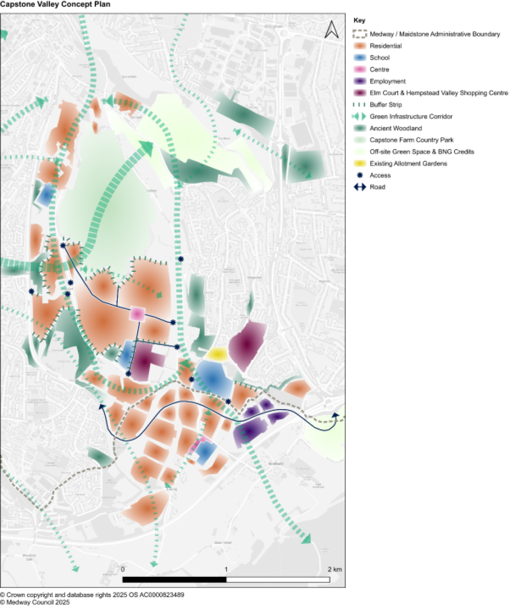
Figure 13: Captstone Valley Concept Plan View responses
Policy SA7: Capstone Valley View responses
Objective
- By 2041, the Capstone Valley will comprise a sustainable urban extension of up to 3,958 new homes, a primary school, a secondary school and a local centre. Biodiversity and public access to open space will be improved. A connection between North Dane Way and M2 Junction 4 will provide for an orbital bus route.
Criteria
- Mill Fields (LW8) will include:
- 2.4 ha of land for a new three-form entry primary school, phased in the latter part of the plan period, in accordance with the latest IDP.
- A local centre commensurate with a new community of 2,330 new homes, including provision of convenience floorspace that meets the day-to-day needs of the local community only.
- Abbotts Court Farm (HW3) will include 10 ha of land for a new secondary school, phased in the first five years of the plan period, in accordance with the latest IDP.
- Mature vegetation cover at the northern boundary of Abbotts Court Farm (HW3) will be retained to screen new development from Chapel Lane allotment gardens.
- Medway Council will consider opportunities for self-build and custom housebuilding in the disposal of Abbotts Court Farm (HW3).
- As per Policy DM21, new open space and playing pitches will be provided in line with the Fields in Trust (2024) standards, plus 0.25 ha for new allotment gardens.
- A green infrastructure strategy and an approved masterplan will determine how much natural and semi-natural open space will be provided on-site.
- Most of the required natural and semi-natural open space is expected to be provided off-site at Darland Farm, with Capstone Farm Country Park improved as a biodiversity asset.
- Darland Farm will be protected as natural and semi-natural open space in perpetuity. Darland Farm may also provide for off-site Biodiversity Net Gain credits.
- New development edges, buffer strips and access to Capstone Farm Country Park will be agreed with Medway Council.
- A green infrastructure strategy will inform the overall design and layout.
- A review of historic landscape components, such as past land divisions, field parcels, boundaries, shaws, hedgerows and woodland, will provide a foundation for subsequent masterplanning.
- Internal landscaping will respond to the local landscape character, including multifunctional ecological, drainage and active travel corridors.
- The specification of buffer strips close to Ancient Woodland will be agreed with Natural England and Medway Council.
- The provision of street trees – plus the design, placement and species to be used – will be aligned with a street hierarchy.
- The management of green infrastructure will be secured by Section 106 agreement.
- An open space strategy, including long-term management plans, will identify opportunities for an on-site community sports hub and off-site outdoor sports provision.
- A Community Use Agreement with the new primary and secondary schools would help to ensure access to playing pitches and the most efficient use of land.
- North Dane Way will connect to M2 Junction 4 via a spine road through Lidsing.
- New development will have appropriate interfaces with Elm Court and Capstone Farm Country Park.
- The design and layout of streets will provide for maximum bus accessibility and connections to an orbital bus route.
Subsequent design principles
- The Capstone Valley Concept Plan shows an indicative layout.
- The applicant will produce a landscape-led masterplan, to be approved by Medway Council, to guide subsequent planning applications and further approval of details. The masterplan will be informed by a green infrastructure strategy and an open space strategy.
Site-specific information
|
Policies Map ID |
Name |
Land uses |
Number of new homes and/or floorspace within plan period |
Plan period (Years) |
|
HW3 |
Abbotts Court Farm |
Residential, with opportunity for self-build and custom housebuilding Secondary school |
Up to 75 homes |
6-10 |
|
HW11 |
Broomfield Farm |
Residential |
Up to 60 homes |
1-5 and 6-10 |
|
LW4 |
Sharstead Farm |
Residential |
Up to 670 homes |
1-5, 6-10 and 11-15 |
|
LW6 |
East Hill |
Residential Primary school GP surgery |
Up to 698 homes |
1-5 and 6-10 |
|
LW7 |
Gibraltar Farm |
Residential |
Up to 450 homes |
1-5 and 6-10 |
|
LW8 |
Mill Fields |
Residential Primary school Local centre |
Up to 2,000 homes |
1-5, 6-10, 11-15 and 15+ |
|
LW10 |
Capstone Stud Farm |
Residential |
Up to 5 homes |
1-5 |
14.9 Hoo St Werburgh and Chattenden
14.9.1 The Hoo Peninsula is a distinctive part of Medway, its villages, rural and estuarine landscapes contrasting markedly with the urban area. The peninsula itself is an area of contrasts. The estuary location has supported the development of strategically important economic activities, particularly in the energy sector. The industrial infrastructure sits in a coastal landscape of marshes and mudflats. The Thames and Medway marshes and estuaries are of international importance for wildlife, particularly wintering birds. Villages of various sizes across the peninsula are home to around 25,000 people. Hoo St Werburgh and Chattenden is the largest parish, with 13,782 residents in 2021. The population of the parish has increased significantly, nearly doubling in size between the Census periods in 2001 and 2021. View responses
14.9.2 Hoo St Werburgh (Hoo) is the main village on the peninsula, providing some services such as a secondary school and sports centre to communities across the wider rural area. There is a large employment area to the south of the village at Kingsnorth. However, the service base is limited, and capacity is stretched in particular areas, such as health. Some infrastructure is ageing and needs updating. The range of services and facilities does not reflect the size of the communities, and many people travel to towns in Medway to access key services such as supermarkets and leisure. Public transport services do not always meet residents' needs and there is a high reliance on cars. Further housing growth must be accompanied by investment in new and expanded services, including wider choice of transport and local services, to provide for sustainable development. View responses
14.9.3 The Hoo St Werburgh and Chattenden Neighbourhood Plan was adopted in January 2025. Its vision is:
'to support sustainable growth and development to meet diverse local needs, addressing Climate Change, and preserving or enhancing the distinctive character and local facilities of the parish, the village of Hoo St Werburgh and hamlet of Chattenden and their rural landscape settings'.
14.9.4 The Medway Local Plan recognises these ambitions set by local communities.
14.9.5 Hoo and Chattenden have potential to expand as part of Medway's development strategy. The rural location provides an alternative offer to urban regeneration sites, meeting wider housing needs and bringing investment to improve local services, such as transport, retail, and health facilities. New development provides opportunities to enhance sustainability, through reducing the need to travel further for services, increasing travel choice, and building in green infrastructure to support healthy living and resilience to climate change. View responses
14.9.6 To the south of Hoo, the Kingsnorth employment area has an important role in Medway's economy, and provides the opportunities for boosting economic growth and innovation over the plan period. View responses
14.9.7 The level of development planned for Hoo and Chattenden will involve significant change. Growth will be planned at a strategic level across the parish, and delivered through distinct, but connected neighbourhoods and villages, that complement the existing communities. This strategic policy includes Chattenden to reflect the close relationship between the two villages, and the opportunities to plan effective green infrastructure, transport and services. View responses
14.9.8 In planning for Medway's future growth, it is important to ensure the distinct identities of Hoo and Chattenden. Development must retain the separation of the historic villages of Hoo and Chattenden, and avoid coalescence. A landscape buffer is a key part of the strategic planning, providing for views over open landscape. View responses
14.9.9 The wider landscape setting of the coast and countryside is an intrinsic consideration of the approach to planning for development of Hoo and Chattenden. A partnership strategic environmental programme is required to provide an effective framework for addressing the impacts of development. This will protect the designated sites, along the estuary and surrounding countryside, through coordinated measures of land and visitor management. The strategic programme will support a landscape led development, delivering for nature and people. It provides opportunities for water and wetland features to be managed to strengthen the landscape structure and quality around Hoo, and to address flood risk and improve biodiversity. It will also involve new parklands, open spaces, and walking routes for residents, supporting healthy communities.
14.9.10 The Hoo Peninsula is a unique landscape of undulating, farmed land demonstrating evolution of farming practices in an isolated location, historic and modern river and other industry, and a long time depth history of military defence. The Hoo Peninsula has a rich heritage, including its military history, as clearly evidenced in English Heritage's Hoo Peninsula Historic Landscape Study, 2015. These links to the past are important in defining a sense of place and shaping the area's future growth. There are clear opportunities to reflect heritage in new development, such as the use of the Hoo Stop Line as a component of a Green Infrastructure Strategy. A Heritage Impact Assessment will be required with planning applications.
14.9.11 Growth around Hoo and Chattenden over the plan period will be largely residential led, but will also include economic development. Kingsnorth will continue to develop and expand its role as a leading location in Medway's economy. In addition, there will be commercial development at Deangate Retail Park and in conjunction with centres in the neighbourhoods across Hoo and Chattenden.
14.9.12 The scale of planned development and the sensitivity of the rural location require a considered strategic approach to growth. A masterplan led development framework will be required to provide additional guidance on design, infrastructure and delivering sustainable growth.
14.9.13 Figure 14 shows a concept plan for the Hoo St Werburgh & Chattenden.
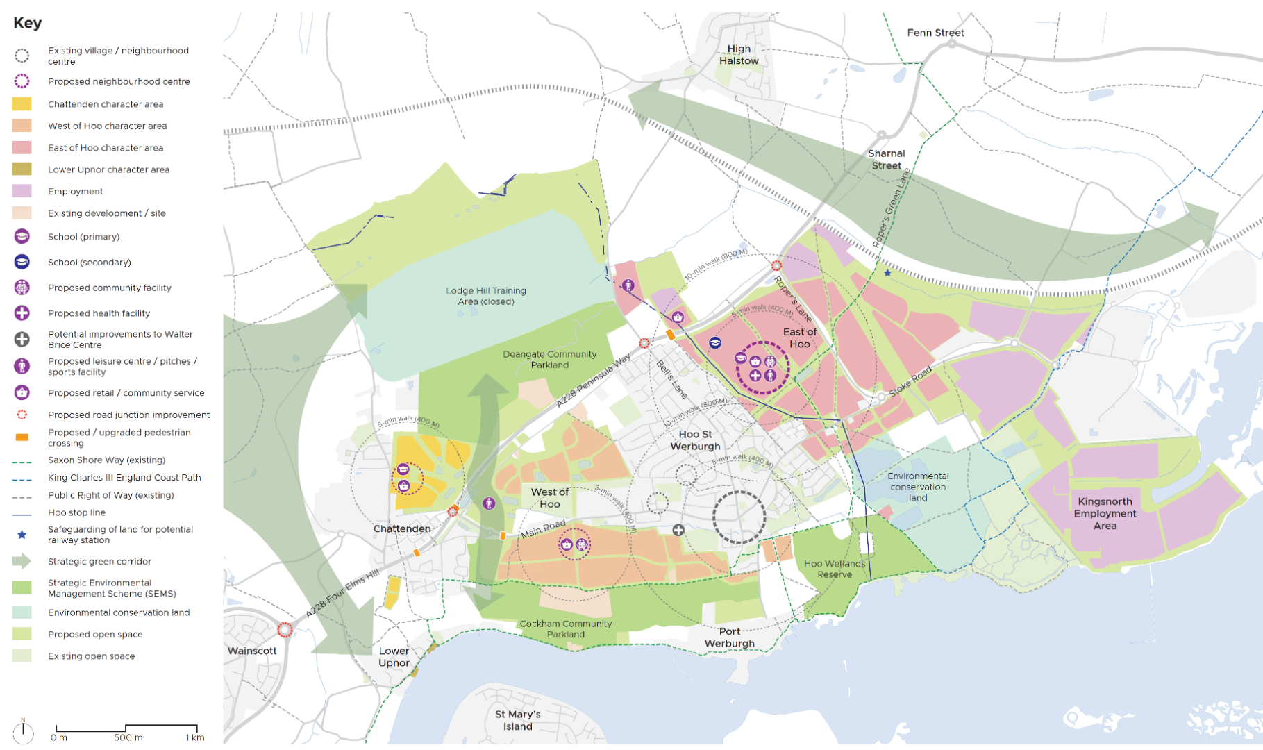
Figure 14: Hoo St Werburgh and Chattenden Concept Plan View responses
Policy SA8: Hoo St Werburgh and Chattenden View responses
Objectives
- By 2041 Hoo St Werburgh will have strengthened its role in serving local residents and wider villages across the Hoo Peninsula. Sustainable development will provide around 4,700 new homes, aligned with improvements in transport, community services and facilities, retail, and new job opportunities. Growth in Chattenden will provide for 600 new homes and new and enhanced services.
- Development will be landscape led, responding sensitively to the natural surroundings and the area's heritage.
- The separation of Hoo and Chattenden as distinct settlements will be secured through a strategic landscape corridor.
- Development will provide for distinctive neighbourhoods, with strong connections to the existing and new settlements.
Criteria
- Development will come forward in accordance with a strategic masterplan for Hoo and Chattenden, providing a framework for design, landscape and green infrastructure, heritage, services, employment, transport, infrastructure, defining distinctive neighbourhoods and centres.
- Development will be delivered in phases across the plan period, and extend beyond into the 2040s. Infrastructure delivery is linked to the phased growth, with triggers identified in the Hoo Peninsula Infrastructure Plan.
- Development will provide for a mix of housing, in line with Policy T2 Housing Mix and reflecting the communities' needs as evidenced in the Medway Local Housing Needs Assessment, 2025, or subsequent evidence updates. The Council expects this scale of growth to meet a wide range of housing needs, including specialist provision for older people and people with disabilities, and self build and custom housing.
Centres and retail
- Development will contribute to a network of centres across Hoo and Chattenden, with a main centre strengthening Hoo's role as a focus for services for its residents and the wider Hoo Peninsula, supported by smaller centres at neighbourhood level.
- Land at HHH19 is allocated for the development of Deangate Retail Park, with up to 50,000 sqf GIA retail floorspace (Class Ea), principally providing for a 25,000 sqf GIA supermarket to cater for the Hoo Peninsula, with other retail and ancillary food and drink (Class Eb) of up to 7,500 sqf GIA. This will be accompanied with a new pedestrian crossing over the A228 and associated traffic calming measures, providing access to the new retail park and the wider Deangate area.
- Land to the east of Hoo (HHH22) is identified as the preferred location for the main centre. This will provide a key destination for residents, with community services, such as health and leisure, accessible and attractive walking and cycling links, including to the new secondary school.
- Development coming forward in the defined neighbourhoods will align with the strategic masterplan and provide for a network of small centres with uses to meet daily needs of residents without adversely impacting upon existing centres, specifically the established Hoo village centre.
Infrastructure
- Developers will be required to support the delivery of an Infrastructure Plan for Hoo and Chattenden, providing for the phased implementation of services. Development will deliver a wide range of community services and infrastructure, reflecting the needs arising from the scale of planned growth in the context of the existing village offer. This will include provision for:
- A new six-form entry secondary school in accordance with the latest IDP.
- A new two-form entry/1 three-form entry primary school in accordance with the latest IDP.
- Relocation of Chattenden Primary School, with expansion to two-form entry in accordance with the latest IDP.
- A Healthy Living Centre
- A new community centre/hub and investment in increasing capacity in current facilities
- New indoor sports and leisure facility
- Outdoor sports and recreation facilities, including improvements to Deangate Running Track
Transport
- Development shall be designed to ensure strong integration and permeability for pedestrians, cyclists and provision for improved public transport to the surrounding residential neighbourhoods and villages by providing high quality and maintained active travel routes.
- Development will support the improvement of bus services to provide effective sustainable transport links for Hoo and surrounding villages, with consideration of expansion of fast-track bus services linked to the urban area. Land will be safeguarded to the east of Hoo for a future potential use of the freight line for passenger traffic.
- In addition to site specific transport requirements, developers will contribute to the delivery of highways mitigations to provide capacity to accommodate growth at:
- Four Elms roundabout
- Main Road, Hoo, junction with A228
- Dux Court Road/Bells Lane junction with A228
- Ropers Lane junction with A228
Environment and heritage
- Development will be landscape led. Growth will be directed within a strategic environmental framework that will define the outward development of Hoo and Chattenden. This will provide an effective buffer to sensitive habitats and connect people to the countryside and coast. The strategy will provide opportunities for sustainable drainage measures to enhance the place-making and character of new development, and provide an integrated approach to the delivery of BNG and strategic mitigation.
- A green infrastructure strategy will inform the design of development, reflecting the neighbourhood approach, and providing connections to surrounding rural area. This will draw on the area's heritage, providing a long-term management plan for historic assets.
- Along with the strategic masterplan development framework, Historic England England's 'Hoo Peninsula Historic Landscape Project' should be referred to in all applications to demonstrate an understanding of and response to the unique character of the rural area. Where appropriate, provision should be made for enhanced interpretation, particularly for WWII era sites, buried and standing. The military heritage of the Hoo Stop Line will be reflected in green infrastructure planning.
- A strategic environmental management plan will be prepared and approved by the Council and Natural England to provide the basis for an integrated programme of measures to safeguard and strengthen the natural environment around Hoo and Chattenden, particularly the SPA, Ramsar sites and SSSIs. Development will contribute towards the implementation of the strategic programme to provide for sustainable development, and contribute to meeting the requirements of PoliciesyS2 and S3) This will include the delivery of:
- Deangate Community Parkland
- Cockham Community Parkland
- Hoo Wetlands
- There is potential to deliver a district heating network to support sustainable energy infrastructure. This will be further explored and reflected in the strategic development framework and masterplan.
Employment
- In addition to the strategic employment sites at Kingsnorth (Policy SA14), development in Hoo and Chattenden will provide for a mix of smaller scale employment land, to provide for balanced growth. This will be located at Deangate Retail Park, east of Hoo, and in conjunction with the neighbourhood centres.
Subsequent design principles
3. Medway Council and the Hoo Consortium, and wider developers will collaborate to produce a Hoo Planning Framework, including a masterplan, to guide planning applications and further approval of details.Site-specific information
|
Policies Map ID |
Name |
Land uses |
Number of new homes and/or floorspace within plan period |
Plan period (Years) |
|
HHH5 |
Land east of Beacon Hill Lane |
Residential |
Up to 50 |
1-5, 6-10 |
|
HHH6 |
Land north-west Ratcliffe Highway, Chattenden |
Residential Primary school |
Up to 550 |
1-5, 6-10 |
|
HHH8 |
Land west of Hoo St Werburgh |
Residential and supporting commercial |
Up to 450 |
1-5, 6-10 |
|
HHH11 |
Land west of Hoo, adjacent to Vidgeon Avenue |
Residential |
Up to 240 |
1-5 |
|
HHH12 |
Land south of Main Road, Hoo St Werburgh |
Residential Community facility |
Up to 1,800 |
1-5, 6-10, 11-15 |
|
HHH22 & HHH31 |
Land either side of Roper's Lane, Hoo St Werburgh |
Residential Employment Secondary school Community facility Retail |
Up to 1,700 |
1-5, 6-10, 11-15, 15+ |
|
HHH24 |
Land north of Stoke Road and east of Walnut Tree Grove, Hoo St Werburgh |
Residential |
Up to 85 |
1-5, 6-10 |
|
HHH25 |
Adjacent to Yew Tree Lodge land to the south of Stoke Road, Hoo |
Residential |
Up to 80 |
1-5 |
|
HHH32 |
Abbots Court, Hoo St Werburgh |
Residential |
Up to 3 |
1-5 |
|
HHH33 |
Land south of Stoke Road adjacent Jacobs Lane |
Residential Community facility |
Up to 330 |
6-10, 11-15 |
|
HHH41 |
Parcel south of Ratcliffe Highway, Hoo St Werburgh |
Residential |
Up to 25 |
1-5 |
14.10 High Halstow
14.10.1 High Halstow is an historic village in the centre of the Hoo Peninsula that expanded significantly in the latter half of the 20th century. The wider parish stretches across the north Kent Marshes to the Thames Estuary. The village has a rural character and setting. The village centre provides a range of services, including village halls, a primary school and pre-school, sports facilities, a shop, pub and church. It is located to the north-east of Hoo, which provides a wider range of services. Like Hoo and Chattenden, the village of High Halstow is close to important environmental sites, and has a rich history.
14.10.2 High Halstow Parish Council is preparing a Neighbourhood Plan which seeks to maintain the rural character of the village, secure quality design in new development, protect the natural and historic environment and maintain a vibrant distinct community. Work on the Neighbourhood Plan has included a Local Housing Needs survey and wider community consultation. This work has identified a need for housing suitable for older people to 'downsize', such as bungalows, and remain in the village community. There is also support for the provision of plots for self and custom build homes in suitable locations in the village.
14.10.3 This Local Plan allocates land to the east of High Halstow for a large extension to the village. This is made up of two sites which are to be planned through a comprehensive masterplan. View responses
Policy SA9: High Halstow View responses
Objective
- By 2041, High Halstow will have grown as a village, providing up to 820 new homes, a new primary school, attractive multi-functional green infrastructure and an additional centre providing commercial and community services. New development will be successfully integrated with the existing village and the surrounding countryside.
Criteria
- Development of the two sites (HHH26 and HHH29) will be brought forward in accordance with a masterplan for the combined area.
- Development will be designed to successfully integrate new and existing communities in the village, through design and community facilities. Development should ensure maximum connectivity and permeability between the site and existing village, such that it is well-integrated with and becomes part of the village, optimising connectivity to and the viability of the village centre.
- Development will retain the distinct identity of High Halstow as an historic village, and avoid coalescence with nearby settlements, through planning for landscape buffers and interface with the countryside setting, seeking opportunities to enhance landscape character.
- Any new development should respect the village feel, should be of a high quality of design and provide defined character areas that reflect variety in house types, layout, density and landscaping.
- Housing shall meet local needs, with reference to the Medway Local Housing Needs Assessment, 2025, and other local evidence, such as in the preparation of the Neighbourhood Plan, or subsequent updates. Development will provide a mix of types and designs of homes, including houses, bungalows, affordable homes and opportunities for self-build.
- Development will provide for a new two form entry primary school in accordance with the latest IDP, located by the new centre, with clear and attractive links to the existing village. The additional centre will complement the historic village centre, and provide space for retail, wider commercial and community facilities.
- Development will be landscape-led and respond to the countryside setting and provide high quality green infrastructure that retains the rural character of the village, and embeds sustainable drainage and active travel in the design.
- New open space will be provided in accordance with the Fields in Trust standards as set out in Policy DM21, and designed to integrate with the rural setting.
- Development shall be designed to ensure strong integration and permeability for pedestrians, cyclists and provision for improved public transport.
- Development will support the improvement of bus services to provide effective sustainable transport links for the village, with consideration of expansion of fast-track bus services linked to the urban area.
- The primary vehicular access will be from the roundabout by Christmas Lane. In addition to site specific transport requirements, developers will contribute to the delivery of highways mitigations to provide capacity to accommodate growth at:
- Four Elms roundabout
- Main Road, Hoo, junction with A228
- Dux Court Road/Bells Lane junction with A228
- Ropers Lane junction with A228
Subsequent design principles
The applicant will produce a masterplan, to be approved by Medway Council, to guide planning applications and further approval of details. The masterplan will be informed by a green infrastructure strategy and an open space plan.
Site-specific information
|
Policies Map ID |
Name |
Land uses |
Number of new homes and/or floorspace within plan period |
Plan period (Years) |
|
HHH15 |
Land adjoining 35 Cooling Road, High Halstow |
Residential |
Up to 5 |
1-5 |
|
HHH26 |
North of Christmas Lane, east of High Halstow |
Residential Education Community and Commercial floorspace |
Up to 760 |
1-5, 6-10, 11-15 |
|
HHH29 |
Parcel north of Christmas Lane, High Halstow |
Residential |
Up to 55 |
1-5 |
14.11 Lower Rainham
14.11.1 Over 1,200 new homes have been built in Rainham in the last 10 years across several suburban sites. The new Leigh Academy secondary school opened in 2021. However, public consultations have highlighted concerns about the lack of supporting infrastructure and the increased pressure on local services. Almost all land surrounding Rainham has been promoted for development in the plan-making process, which reflects the higher-value location. View responses
14.11.2 Lower Rainham is defined by Yokosuka Way (A289), Lower Rainham Road, Bloors Lane Allotment Gardens, Bloors Lane Community Woodland and the Chatham Main Line. These features separate Lower Rainham from the built-up extents of Gillingham, Rainham and Twydall, and provide a transition to the lower-lying marshes of Riverside Country Park.
14.11.3 Lower Rainham has a rural character, with small to medium scale patterns of commercial orchards, arable and pasture fields and equine uses. There are two conservation areas, several listed buildings, scattered farmsteads and residential properties fronting country lanes. The high hedges provide a sense of enclosure, however views across the area are limited. The area is part of a wider 'Fruit Belt' landscape associated with Kent's reputation as the 'Garden of England'.
14.11.4 In 2020, Medway Council refused a planning application that included 1,250 homes. The planning application was subsequently dismissed at appeal in 2021. The Inspector concluded that the benefits outweighed the potential harm to heritage assets. However, the loss of best and most versatile agricultural land, landscape impacts and local highway impacts were not outweighed by the benefits of the development. View responses
14.11.5 A proposal from Small to Medium Enterprise (SME) housebuilders will deliver Rainham Parkside Village at Bloors Farm and Pump Farm, located to the east and to the west of Pump Lane respectively. It is important to note that Rainham Parkside Village will be entirely different to the development that was dismissed at appeal in 2021. View responses
14.11.6 Rainham Parkside Village will comprise fewer homes (750), which will limit the degree of landscape impacts and local highway impacts. A wider mix of uses in a plan-led, larger scale development is intended to address concerns following ad hoc, smaller scale development. The design will respond to the rural character of the area, following a Rural Design Code, and utilise the local 'lane' network. View responses
14.11.7 The NPPF supports the sub-division of larger housing sites because smaller housing sites, on average, deliver significantly quicker. Rainham Parkside Village will be parcelled into smaller developments of under 99 homes. Each parcel can come forward independently, resulting in variation in the design of new housing, which will help to avoid market saturation. View responses
14.11.8 Development proposals in Lower Twydall, to the west of Rainham Parkside Village, will be opposed to conserve the rural setting and to prevent the coalescence of settlements. View responses
14.11.9 Figure 15 shows a concept plan for Lower Rainham. View responses
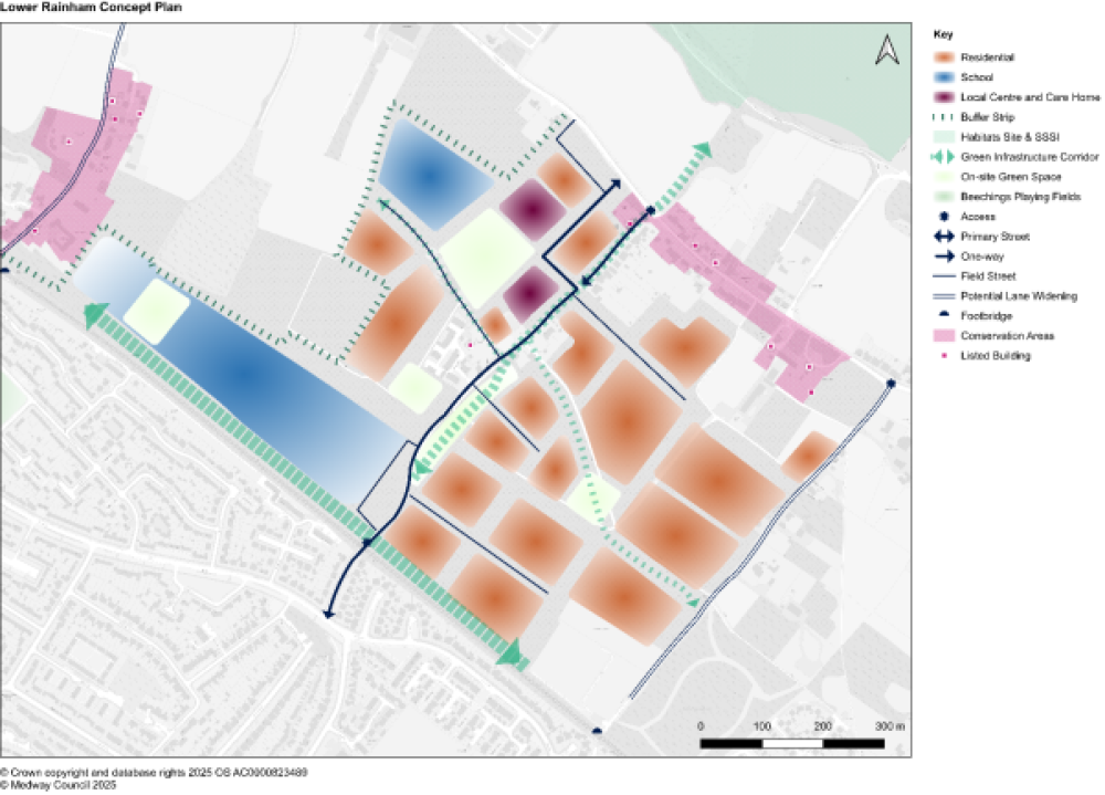
Figure 15: Lower Rainham Concept Plan View responses
Policy SA10: Lower Rainham View responses
Objective
- By 2033, the development of Rainham Parkside Village (RN9) will provide a green backdrop to the adjacent marshes at Riverside Country Park, with improved connections for people and nature.
Criteria
- Rainham Parkside Village (RN9) will include:
- Up to 750 new homes.
- A local centre commensurate with a new community of up to 750 new homes, including:
- a children's nursery;
- 3 ha of land for a two-form entry primary school in accordance with the latest IDP;
- a Community Hub;
- a Health Hub;
- a care home; and
- convenience floorspace that meets the day-to-day needs of the local community only.
- Up to 15 homes for use as temporary living accommodation.
- 8 ha of land for an eight-form entry secondary school in accordance with the latest IDP.
- A Habitats Regulations Assessment and, if required, compensation and/or mitigation will be agreed with Natural England and Medway Council.
- The requirements in policies S2 and S3 must be applied, given the sensitive location.
- Any enhancement in waterfront accessibility will have no adverse impact upon the integrity of the Special Protection Area and Ramsar designations, either alone or in-combination.
- An open space strategy, including long-term management plans, could identify opportunities for off-site outdoor sports provision.
- A Community Use Agreement with the new primary and secondary schools would help to ensure access to playing pitches and the most efficient use of land.
- A green infrastructure strategy will inform the overall design and layout.
- Internal landscaping will respond to the local landscape character, including multifunctional ecological, drainage and active travel corridors.
- The western edge will be defined by a strong defensible landscape buffer to deter development proposals in Lower Twydall.
- The specification of a buffer strip to screen the railway, and to provide an east-west leisure route, will be agreed with Medway Council.
- The provision of street trees – plus the design, placement and species to be used – will be aligned with a street hierarchy.
- The management of green infrastructure will be secured by Section 106 agreement.
- The strategy and guidance set out in the Medway Landscape Character Assessment (2024) for Lower Rainham will inform the design and layout. Uncharacteristic coniferous planting and fencing will be resisted.
- The design and layout of streets will follow a hierarchy:
- The existing Pump Lane will be the primary vehicular accesses and street connecting Lower Rainham Road to Beechings Way. The existing northern end of Pump Lane will be converted to a one-way route to enhance the setting of the listed building. A short new segment will relieve traffic from the northern end of Pump Lane.
- A series of lower order 'Field Streets', which reference the former field lines, will provide vehicular connections across the site.
- The widening of Lower Twydall Lane and Lower Bloors Lane will be explored in subsequent detailed design.
- Pedestrian connections to/from Twydall via the two existing railway footbridges at Lower Twydall Lane and Lower Bloors Lane will be improved.
- Have regard to the setting of the Lower Twydall and Lower Rainham conservation areas and nearby listed buildings.
- SME housebuilders will deliver Rainham Parkside Village, overseen by a master SME developer. Development will come forward in bespoke SME-sized parcels with associated SME Partners under an SME Framework.
Subsequent design principles
- The applicant will produce a masterplan, to be approved by Medway Council, to guide subsequent planning applications and further approval of details. The masterplan will be informed by a Rural Design Code, a green infrastructure strategy and an open space strategy.
Site-specific information
|
Policies Map ID |
Name |
Land uses |
Number of new homes and/or floorspace within plan period |
Plan period (Years) |
|
RN9 |
Pump Farm and Bloors Farm |
Residential A children's nursery A two-form entry primary school An eight-form entry secondary school Community Hub Health Hub Care home Convenience floorspace |
Up to 750 homes |
1-5, 6-10 |
|
RN17 |
R/O Queencourt, Berengrave Lane, Rainham |
Residential |
Up to 33 homes |
1-5 |
|
RN23 |
Land west of Station Road, Rainham |
Residential |
Up to 75 homes |
1-5 |
|
RN25 |
Pampa House, Station Road, Rainham |
Residential |
Up to 5 homes |
1-5 |
14.12 Rural Settlements
14.12.1 Medway has a number of smaller villages and hamlets, largely located on the Hoo Peninsula and in the Medway Valley. The Local Plan development strategy includes large residential led site allocations in the rural area, notably focused around Hoo and Chattenden, in conjunction with improved services and infrastructure. View responses
14.12.2 The Council has carried out a Village Infrastructure Audit as evidence for the Local Plan, and assessed the availability and state of services in all parishes. Most of Medway's villages have valued local services, such as shops, halls, churches, play areas, and pubs, and in many cases primary schools. However, the services can be limited in some areas, such as healthcare and public transport. View responses
14.12.3 There is an ageing population in parts of the rural area. Local housing needs assessments, including those prepared as evidence for Neighbourhood Plans, have identified demand from older people to move from large family homes, but stay within their villages. Bungalows are a preferred choice for many. At the other end of the age spectrum, younger people often struggle to find smaller properties locally. The Council wants to support sustainable villages, where residents have access to a choice of housing, and services are maintained, and improved where possible. New development can help to support the future of vibrant villages.
14.12.4 Outside of the large strategic development allocations at Hoo and Chattenden, and High Halstow, the Council is proposing growth in and around other villages. View responses
14.12.5 There are adopted and emerging Neighbourhood Plans in Medway. None of the adopted Neighbourhood Plans in rural Medway include site allocations, but new plans may want to consider how and where their local communities can plan for future development.
14.12.6 Development will need careful consideration of the countryside and coastal landscape and heritage, and accord with a rural character. There are specific sensitivities in proximity to the Kent Downs National Landscape to the south-west of Medway, and the environmental designations on the Hoo Peninsula. View responses
14.12.7 These smaller sites provide opportunities for SME housebuilders and self and custom built housing, which are welcomed in diversifying the housing market in Medway.
Policy SA11: Rural Settlements View responses
Objective
- By 2041, development allocations in Medway's rural area will provide for diversification of housing choice in villages, meeting the needs of rural communities.
Criteria
- The requirements in policies S2 and S3 must be applied, given the sensitive locations.
Site-specific information
|
Policies Map ID |
Name |
Land uses |
Number of new homes and/or floorspace within plan period |
Plan period (Years) |
|
AS11 |
Land at The Street, Stoke, Rochester |
Residential |
Up to 10 |
1-5 |
|
AS25 |
Land west of Edinburgh Road, Grain |
Residential |
Up to 34 |
1-5 |
|
CHR14 |
Port Medway Marina, Cuxton |
Residential |
Up to 49 |
1-5, 6-10 |
|
SR4 |
North Little Church Road, west of Town Road, Cliffe Woods |
Residential |
Up to 130 |
1-5 |
|
SR7 |
West of Woodlands development, Town Road, Cliffe |
Residential |
Up to 44 |
1-5 |
|
SR14 |
Land south of View Road, Cliffe Woods |
Residential |
Up to 49 |
1-5 |
|
SR51 |
Land to the east and west of Church Street, Cliffe |
Residential |
Up to 250 |
1-5, 6-10 |
14.13 Other Sites
14.13.1 The site allocations have been organised by a geography which reflects the spatial strategy, however there are 23 disparate individual site allocations across Medway, hence their 'Other' category.
Policy SA12: Other Sites View responses
Site-specific information
|
Policies Map ID |
Name |
Land uses |
Number of new homes within plan period |
Plan period (Years) |
|
AS2 |
Fenn Farm Yard, St Mary Hoo, Rochester |
Residential |
Up to 4 |
1-5 |
|
AS28 |
Land west of Port Victoria Road, Grain |
Residential |
Up to 9 |
1-5 |
|
AS6 |
Adjacent to Fenn Street and Ratcliffe Highway, St Mary Hoo |
Residential |
Up to 40 |
1-5, 6-10 |
|
AS10 |
White Horse Public House, The Street, Stoke |
Residential |
Up to 5 |
1-5 |
|
FP6 |
Former University College for Creative Arts, Fort Pitt, Rochester |
Residential |
Up to 102 |
1-5 |
|
GN8 |
176 Grange Road, Gillngham |
Residential |
Up to 17 |
1-5 |
|
GS23 |
The Yard, 1a Milton Road, Gillingham |
Residential |
Up to 5 |
1-5 |
|
GS35 |
Former factory, 111 Rainham Road |
Residential |
Up to 12 |
1-5 |
|
HW6 |
Blowers Wood, Maidstone Road, Hempstead |
Residential |
Up to 88 |
1-6, 6-10 |
|
LW2 |
419 Walderslade Road, Walderslade |
Residential |
Up to 18 |
1-5 |
|
REWW3 |
Miles Place, Delce Road, Rochester |
Residential |
Up to 11 |
1-5 |
|
RN22 |
311 Station Road, Rainham |
Residential |
Up to 8 |
1-5 |
|
RN24 |
33 High Dewar Road, Rainham |
Residential |
Up to 9 |
1-5 |
|
RN28 |
Moor Street, Rainham |
Residential |
Up to 66 |
1-5 |
|
RN29 |
Chestnut Court, Otterham Quay Lane, Rainham |
Residential |
Up to 14 |
1-5 |
|
RN30 |
Land north of railway line and west of Seymour Road, Rainham |
Residential |
Up to 90 |
1-5 |
|
RN31 |
Land west of Seymour Road, Rainham |
Residential |
Up to 80 |
1-5 |
|
RN32 |
Seymour Road, Rainham |
Residential |
Up to 46 |
1-5 |
|
RWB2 |
Medway Bridge, Marina Manor Lane, Rochester |
Residential |
Up to 36 |
1-5 |
|
RWB11 |
1-4 Eastgate Court, Rochester |
Residential |
Up to 5 |
1-5 |
|
RWB12 |
22-26 Victoria Street, Rochester |
Residential |
Up to 3 |
1-5 |
|
RWB25 |
Acorn Wharf Shipyard, Rochester Riverside |
Residential |
Up to 132 |
1-6, 6-10 |
|
SR47 |
Fleet House, Upnor Road, Lower Upnor |
Residential |
Up to 9 |
1-5 |
|
SR48 |
Patmans Wharf, Upnor Road, Upnor |
Residential |
Up to 8 |
1-5 |
|
SR49 |
Lower Upnor Riverside opposite Brissenden Close |
Residential |
Up to 6 |
1-5 |
|
T3 |
Lennox Wood, Petham Green, Twydall |
Residential |
Up to 20 |
1-5 |
|
W3 |
Former Medway Fire Station, Star Mill Lane, Gillingham |
Residential |
Up to 12 |
1-5 |
|
W4 |
41 Barnsole Road, Gillingham |
Residential |
Up to 5 |
1-5 |
|
W7 |
Canada House, Barnsole Road, Gillingham |
Residential |
Up to 21 |
1-5 |
14.14 Frindsbury Peninsula Opportunity Area
14.14.1 Medway City Estate (MCE) is a large employment area located on the former marshland of the Frindsbury Peninsula. Largely developed as an Enterprise Zone in the 1980s and 1990s, MCE is compromised by a poor-quality public realm due to the legacy of its original designation and fragmented land ownership. View responses
14.14.2 MCE suffers from peak hour traffic congestion, hazardous on-street parking, flooding issues, a lack of green space and more generally a poor image, despite its riverside setting and views of Rochester. The existing buildings cannot meet modern occupier requirements, while there is limited scope for expansion due to high site coverage and low eaves. These factors deter maintenance and investment. There is a high level of occupancy, however this may reflect the lack of credible alternative locations. View responses
14.14.3 The comprehensive redevelopment of MCE would present numerous challenges including: View responses
- overcoming various constraints;
- the complexity of land assembly;
- the relocation of existing businesses;
- land preparation; and
- infrastructure costs.
However, representations on behalf of Veetee Rice Limited, a food manufacturer, have highlighted the potential for a local business to act as a catalyst for a landmark mixed-use regeneration area.
14.14.4 Veetee is one of the largest businesses at MCE, occupying three sites for processing, cooking and storage. Veetee is committed to Medway and has explored relocating to a modern, integrated facility at Kingsnorth. However, any relocation would need to be facilitated by value and revenue generated from the redevelopment of Veetee's three sites at MCE, which could be partially delivered during this plan period. View responses
14.14.5 However, piecemeal development would miss opportunities to deliver the full potential of the Frindsbury Peninsula. In the long-term, new urban quarters defined by the River Medway could accommodate thousands of new homes and employment areas. Clearly a comprehensive, collaborative approach is required to address the challenges noted above, particularly the timely relocation of existing businesses to new employment areas in Medway, such as Kingsnorth. The Frindsbury Peninsula is therefore designated as an 'Opportunity Area'.
14.14.6 Farrells, on behalf of Medway Council, produced a 'Medway City Estate Vision' concept plan in 2010. The plan highlighted the potential for: View responses
- a riverside path to/from Strood Riverside, a prominent regeneration site;
- a corridor for ecosystems, a recreational central park and a buffer for flooding and rainwater;
- an opportunity to enhance the natural landscape and become a green gateway at Whitewall Creek;
- development of the eastern edge to be worthy of the context set by Chatham Historic Dockyard; and
- specific building(s) and major public space on the southern end.
14.14.7 Representations from the Environment Agency have highlighted the need to deliver strategic flood risk infrastructure and river enhancement. The north-western area and the southern end are within Flood Zone 3. These areas could be designed to flood. This could avoid the need for 'hard' flood risk infrastructure to protect Chatham and Strood town centres, while creating new inter-tidal habitat. View responses
14.14.8 A Vision Document commissioned by Veetee highlighted similar opportunities for the Frindsbury Peninsula. Taken together, the initial work has informed a concept plan for the Frindsbury Peninsula, shown in Figure 16. View responses
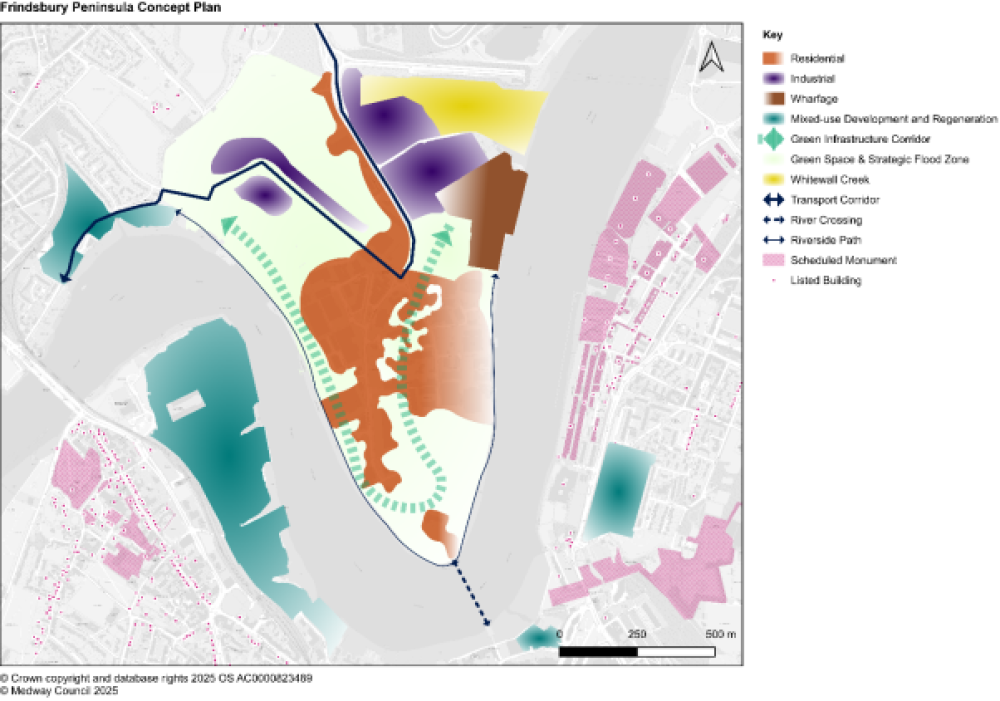
Figure 16: Frindsbury Peninsula Concept Plan View responses
Policy SA13: Frindsbury Peninsula Opportunity Area View responses
Objective
An initial phase of development will be delivered in the latter part of the plan period, following the managed release and relocation of some existing businesses, providing a catalyst for a landmark mixed-use regeneration area extending beyond the plan period.
Criteria
- The Frindsbury Peninsula (SR53) will include:
- An initial phase of development of up to 690 new homes within the plan period as part of a large-scale, mixed-use regeneration area.
- An initial phase of development will not jeopardise future opportunities identified on the Frindsbury Peninsula Concept Plan.
- The planning application(s) for an initial phase of development will be guided by a Frindsbury Peninsula Planning Framework.
- An initial phase of development of up to 690 new homes within the plan period as part of a large-scale, mixed-use regeneration area.
- The requirements in policies S2 and S3 must be applied, given the sensitive location.
- Have regard to the setting of the Chatham Historic Dockyard, Frindsbury and Manor Farm and Star Hill to Sun Pier conservation areas, scheduled monuments at Chatham Historic Dockyard and nearby listed buildings.
Subsequent design principles
- Medway Council will produce a Frindsbury Peninsula Planning Framework by 2030/31 to manage the medium to long-term redevelopment of MCE, including a riverside strategy, an economic strategy and the delivery of strategic flood risk infrastructure.
14.15 Employment Sites
14.15.1 The 2025 Employment Land Needs Assessment (ELNA) identified the following minimum need for employment floorspace: View responses
- 204,000 sqm of industrial floorspace.
- 36,500 sqm of office floorspace.
14.15.2 The development pipeline is sufficient to meet the quantum of employment land needs, however there remains a shortage of built stock. The development pipeline is almost entirely led by Kingsnorth and the Isle of Grain, which are among the largest sites for economic growth in the Thames Estuary and the wider region. The Medway Local Plan 2003 included two strategic site allocations at Kingsnorth and the Isle of Grain, i.e. Policy S12 (Kingsnorth) and Policy S13 (Isle of Grain).
14.15.3 Policy S12 designated a 219 ha site at Kingsnorth for industrial, storage or distribution and Sui Generis uses (B1c, B2, B8 prior to 1 September 2020). The policy provided for the expansion or relocation of businesses in the urban area.
14.15.4 London Medway Commercial Park, located at Kingsnorth, was granted outline planning permission in 2009. There have been many reserved matters applications for the individual plots, such as Plot 1a which was completed in 2019 to accommodate Amazon's distribution warehouse. An 8,925 sqm extension to Damhead Creek Power Station has been implemented, but it is not under construction. More recently, Medway Council's Planning Committee resolved to grant outline planning permission for MedwayOne (MC/21/0979), a 324,450 sqm development of employment floorspace, on the former Kingsnorth Power Station site.
14.15.5 As brownfield / previously developed land, the former Kingsnorth Power Station site has required investment to remediate contamination to enable MedwayOne, which is anticipated to be developed during the early part of the plan period.
14.15.6 The Kingsnorth Expansion Area (HHH35) comprises greenfield land to the west of Kingsnorth. It will adjoin new housing to the east of Roper's Lane, helping to ensure Hoo St Werburgh is a sustainable location for large scale growth. New housing to the east of Roper's Lane is anticipated to be developed during the latter part and post-plan period. The Kingsnorth Expansion Area should play an important role in the managed release and relocation of some businesses from MCE.
14.15.7 However, greenfield employment land is likely to be more commercially attractive to potential occupiers, and this could undermine the Council's 'brownfield first' spatial strategy. MedwayOne is a consented development, therefore it will benefit from the first tranche of vehicle trip credits. View responses
14.15.8 Policy S13 designated a 630 ha site on the Isle of Grain for port activities and industrial, storage or distribution and Sui Generis uses (B1c, B2, B8 prior to 1 September 2020). The Isle of Grain site benefits from a railhead and deep-water berths.
14.15.9 Grain Business Park was granted outline planning permission (MC/09/1628) in 2009. In 2015, a reserved matters application took account of a revised masterplan which reduced the maximum permitted floorspace to 298,383 sqm. A subsequent reserved matters application was also granted in 2015 for the first phase of 16,770 sqm. The residual permitted floorspace is therefore 282,203 sqm. In February 2020, a Lawful Development Certificate was approved confirming that the outline permission had commenced. The landowner, National Grid, intends to realise the full potential of the Isle of Grain site. However, the Council anticipates less storage and distribution floorspace coming forward due to the remote location. A 'call for sites' submission noted the need to retain a broad range of uses in any site allocation. The Isle of Grain site has been safeguarded under Policy S11 - Existing Employment Provision. View responses
Policy SA14: Employment Sites View responses
Objective
- By 2041 new employment opportunities, distributed across Medway, will boost economic growth, address outward commuting and improve local wages in new sectors. As part of mixed-use schemes, new offices in town centres will support the regeneration agenda. An initial phase of development on the Frindsbury Peninsula will be coordinated with the emerging Kingsnorth Expansion Area.
Criteria
- The Council will support a range of employment land uses, i.e. EG(iii), B2 and B8 and sui generis (of an employment nature), subject to accordance with all other relevant Local Plan policies.
- Development proposals other than EG(iii), B2 and B8 and sui generis (of an employment nature) will only be supported where it is demonstrated that:
- There are no alternative locations.
- The proposed use is ancillary to the primary employment use of the individual building or site.
- Kingsnorth Expansion Area is anticipated to be developed during the latter part of the plan period, i.e. after employment sites on previously developed land have been occupied.
- Kingsnorth Expansion Area (HHH35) will have regard to the Frindsbury Peninsula Planning Framework concerning the managed release and relocation of existing businesses at MCE.
- The Council will support new offices in town centres, particularly Chatham, as part of mixed-use schemes.
- The requirements in policies S2 and S3 must be applied, given the sensitive location. In addition, employment development proposals will assess the in-combination impact of industrial emissions (with traffic emissions) upon European sites specifically.
Subsequent design principles
- Planning applications for Deangate Retail Park (Flanders Farm) (HHH19) and Kingsnorth Expansion Area (HHH35) will have regard to the Hoo Development Framework (2025).
Site-specific information
| Policies Map ID | Name | Land uses and floorspace within plan period | Plan period (Years) |
|---|---|---|---|
| CHR16 | Cuxton Pit 1 | EG(iii) / B2 / B8 / Sui generis (of an employment nature) - 25,300 sqm | 6-10 |
| CHR17 | Cuxton Pit 2 | EG(iii) / B2 / B8 / Sui generis (of an employment nature) - 14,600 sqm | 6-10 |
| CHR18 | 3 Acre Field | EG(iii) / B2 / B8 / Sui generis (of an employment nature) - 3,500 sqm | 6-10 |
| FH1 | Innovation Park Medway | B2 - 11,248 sqm EG(iii) - 21,000 sqm |
1-5, 6-10 |
| HHH19 | Deangate Retail Park (Flanders Farm) | B2 - 14,400 sqm | 1-5 |
| HHH35 | Kingsnorth Expansion Area | EG(iii) / B2 / B8 / Sui generis (of an employment nature) - 157,000 sqm | 11+ |
| HHH36 | MedwayOne (Former Kingsnorth Power Station) | EG(iii) / B2 / B8 / Sui generis (of an employment nature) - 324,450 sqm, allowing flexibility in the permitted development parameters (MC/21/0979) | 1-5, 6-10 |
| RWB5 | Land adjacent to Royal Mail Depot, Maidstone Road, Rochester | EG(iii) / B2 / B8 / Sui generis (of an employment nature) - 3,693 sqm | 6-10 |
| SMI6 | Basin3 Campus, Chatham Waters | EG(iii) / B2 / B8 / Sui generis (of an employment nature) as per the approved development parameters - 31,000 sqm | 1-5 |