Arches Chatham Neighbourhood Plan - Regulation 16
Chapter 4: Site Allocations
This section presents 8 site allocations within the Neighbourhood Area. Site allocations are sites which are expected to come forward for potential development during the plan period of the ACNP, which is 2022-2040. The allocations are outlined within the plan with a site boundary, the indicative land use(s), and the indicative amount of development and building heights. The allocations also include information regarding the key development principles for each site, including access arrangements, flood risk and, where applicable, heritage impact.
The site allocations should act as a guide to shape any forthcoming development proposed for those sites.
Development of the sites remains at the discretion of the landowner(s). These allocations should help give greater certainty and clarity to landowners and developers on what is expected and to ensure that potential development aligns with the community's vision and aspirations.
All sites allocated for development in the Neighbourhood Area lie within an Impact Risk Zone in relation to potential detrimental impact on the Medway and the Thames SPAs and Ramsar Sites.
Any new developments within this area will require financial contributions towards the Thames, Medway and Swale Estuaries Strategic Access Management and Monitoring Strategy (SAMM) to mitigate increased recreational disturbance on coastal SPAs and Ramsar Sites. A report on the site allocations process is found in Appendix E. All sites allocated in this Neighbourhood Plan have been analysed as part of a Habitats Regulations Assessment (HRA) and Strategic Environmental Assessment (SEA).

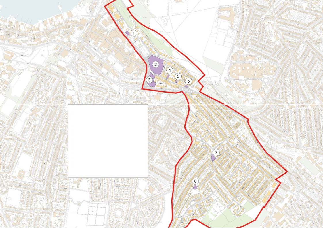
Site allocations
- The Brook and King Street land
- Former Go Outdoors
- Union Place
- 393 High Street
- Pembroke Court car park
- Arches View
- Bright Road
- Dagmar Road
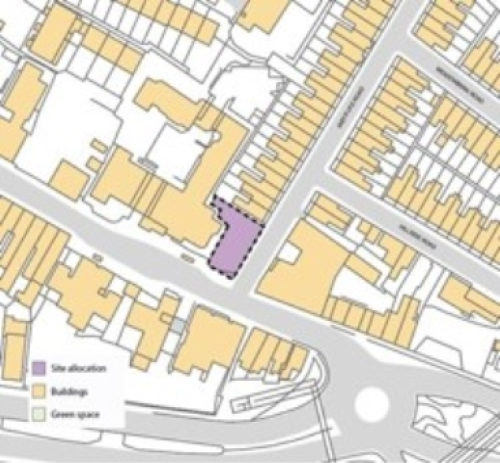
Site 1 - The Brook and King Street land
Existing use: Vacant land.
Land ownership: MHS Homes and Medway Council
Availability & viability: The site is included as part of a wider allocation within the 2019 SLAA (site reference 866), which indicated a site capacity of 23 homes and an expected delivery timeframe of 6-10 years.
Site parameters:
- Site area: 0.06 hectares
- Indicative future use(s): Residential
- Indicative site capacity: 100-250 dwellings per hectare
- Maximum height parameter: 6 storeys (see Design Code)
- Flood zone: Low risk with a high risk of surface water flooding Land ownership: mhs homes and Medway Council.
Key development principles: The site is suitable for residential development with primary access to the south and east of the site to provide continuity with the existing street layout. Any future development should ensure that access and amenity space should be located to the northern part of the site which is less susceptible to traffic noise and pollution.
Heritage: The site is situated within the setting of the Brompton Lines Conservation Area, Brompton Lines Scheduled Monument and the Grade I-listed Naval War Memorial. It is also located approximately 25m to the north of 'The Brook Low Level Pumping Station' Scheduled Monument.
Relevant planning history: N/A
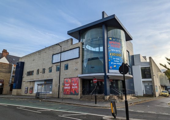
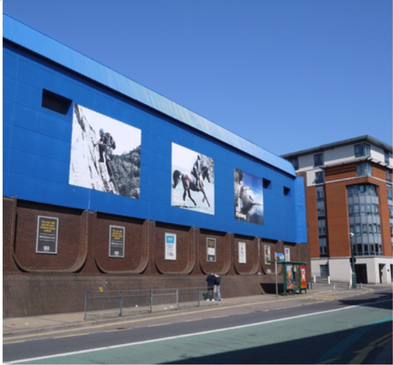
Site 2 - Former Go Outdoors
Existing use: Former Go Outdoors superstore, a former indoor market hall and the Market Hall multi-storey car park.
Availability & viability: The site was identified as suitable and available in the 2019 SLAA with a capacity of 120 homes and an expected delivery timeframe of 11-15 years (site reference 760). Furthermore, the Chatham Town Centre Masterplan 2019 indicates that the redevelopment of the site is deliverable in the medium-term between 2025 and 2030 (Opportunity Site V). An urban design competition for the site was commissioned by the former Head Tenant, Lightstone Chatham LLP, in 2019, which included entries from Pod Architects and Design Engine Architects, demonstrating a commitment to explore future development options at the time. In 2022, Arpenteur secured the unconditional purchase of the site as a development and investment opportunity to provide a new residential mixed use quarter for Chatham.
Site parameters:
- Site area: Circa 1.34 hectares
- Indicative future use(s): residential-led mixed use
- Indicative site capacity: 100-250 dwellings per hectare
- Maximum height parameter: 6 storeys (see Design Code)
- Flood zone: Low risk
Land ownership: Medway Council (freehold and sub-lease), Arpenteur (head lease) and Go Outdoors Ltd (sub-lease).
Key development principles: Topographical considerations include the land rising towards the east of the site with a level change of approximately 9 metres from the land to the south west. Any future development should ensure an active frontage of mixed uses on the High Street in order to repair the historic urban gain of the street. Proposals should seek to achieve enhanced permeability and pedestrian connectivity to improve connections between the Great Lines Heritage Park and Chatham town centre.
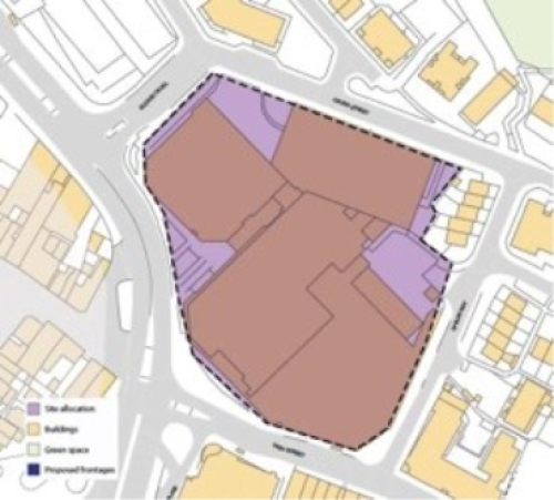
Heritage: The site is situated within the setting of the Brompton Lines Conservation Area, Brompton Lines Scheduled Monument and the Grade I-listed Naval War Memorial.
This town centre site represents a hugely influential site for the future of Chatham. This positive development of this piece of land could be the catalyst for a greener, healthier and happier Chatham. At present this site does not serve the interests of the community or contribute to the sustainable development of Chatham as a whole.
- In accordance with the policies set out in this Neighbourhood Plan, the development of this site should:
- Reduce the impact of The Brook, a dual carriageway that splits the town centre into two
- Restitch the High Street back together by fitting into the local context, character, and scale
- Provide a mix of residential, retail, and green spaces to accommodate the needs of the whole community and minimise the need for private vehicle use
- Contribute to increased levels of greenery and biodiversity in the town centre
- Provide a mix of housing and tenure types that responds to the needs of the local community
- Prioritise sustainable travel and pedestrian movement by limiting vehicle movement through the development
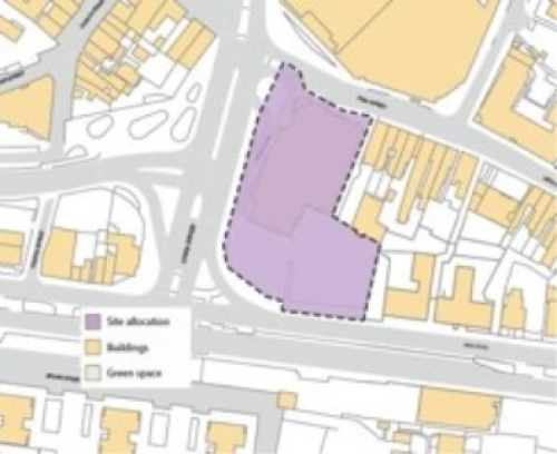
Site 3 - Union Place
Existing use: Former Buzz Bingo and Union Place Car Park.
Availability & viability: In 2022 this site, in part, was acquired by Donard Living with Zetland Capital LLP to pursue a residential-led mixed use development on this entire site (including the Medway Council-owned Union Place car park). ACNF is in conversations with Donard Living and its partners (Savills, Pod Architects, etc) to ensure that any forthcoming proposals are reflective of community aims and aspirations. An outline planning application is anticipated with some matters reserved to fall within Q4 2022/Q1 2023. Medway Council's Cabinet is set to convene where a recommendation has been put forward to declare Union Place Car Park surplus to requirements, so that it can be disposed of for development. It is expected the marketing of the car park is likely to take place in Q4 2022/Q1 2023, with sale completing and the car park closing in spring 2023. Donard Living has publicly announced its intentions to purchase the car park and it has therefore been included within its proposed development.
Site parameters:
- Site area: 0.26 hectares
- Indicative future use(s): Residential-led mixed use
- Indicative site capacity: 100-250 dwellings per hectare
- Maximum height parameter: 6 storeys (see Design Code)
- Flood zone: Low risk with a high risk of surface water flooding
Land ownership: Multiple land owners. A private land developer, Donard Living, owns the former Buzz Bingo, while the adjacent Union Place Car Park is owned by Medway Council.
Key development principles: The site is situated within the Central Medway Air Quality Management Area (AQMA). Any future development should ensure that access and amenity space should be located to the northern part of the site which is less susceptible to traffic noise and pollution.
Heritage: The site is situated within the setting of the Brompton Lines Conservation Area, Brompton Lines Scheduled Monument and the Grade I-listed Naval War Memorial.
Relevant planning history: MC/22/2582 Screening Opinion on EIA for 250 residential dwellings and flexible commercial space (Class E) - demolition of existing building - November 2022.
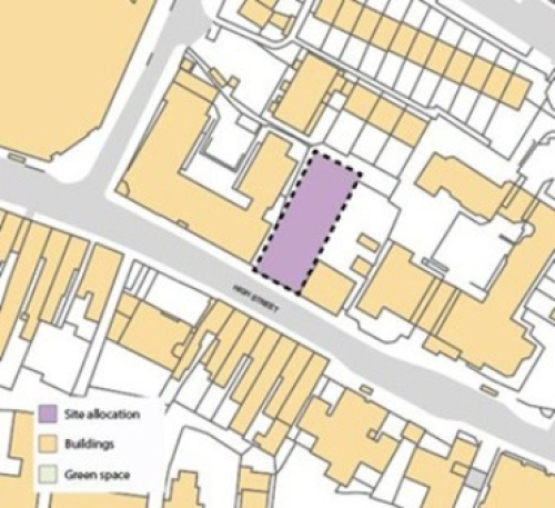
Site 4 - 393 High Street
Existing use: Vacant land.
Land ownership: Private
Availability & viability: The site has been subject to 4 planning applications (MC/06/0452, MC/06/0483, MC/07/2089 and MC/14/1772), demonstrating the availability of the site and the land owner's intention to pursue development.
Site parameters:
- Site area: 0.055 hectares
- Indicative future use(s): Residential
- Indicative site capacity: 100-250 dwellings per hectare
- Maximum height parameter: 6 storeys (see Design Code)
- Flood zone: Low risk with a high risk of surface water flooding Land ownership: Private
Key development principles: Proposals should consider the sloping nature of the upwards towards Cavalier Place in the north east of the site and the site's location within the Central Medway Air Quality Management Area (AQMA).
Relevant planning history: In March 2018, the landowner received planning approval (discharge of conditions) for a 6-7 storey residential building with ground floor retail space.
Site 5 - Pembroke Court car park
Existing use: Private car park. Site parameters:
- Site area: 0.06 hectares
- Indicative future use(s): Residential
- Indicative site capacity: 100-250 dwellings per hectare
- Maximum height parameter: 6 storeys (see Design Code)
- Flood zone: Low risk with a high risk of surface water flooding Land ownership: Ashdown Medway Accommodation Trust.
Key development principles: As there are existing terraced housing adjacent to the site, residential development should aim to continue this typology. Its location at the junction of two streets also provides an opportunity to design a building to effectively turn the corner.
Relevant planning history: N/A
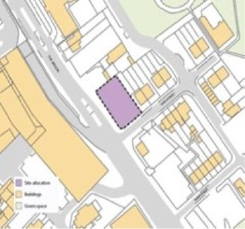
Site 6 - Arches View
Existing use: Vacant land with advertising hoardings.
Availability & viability: Wexham Homes Limited acquired the site from the previous land owner JCDecaux with an intention to develop it.
Three planning applications were submitted between 2019 and 2020 (MC/19/0211, MC/20/1257 and MC/20/3102), with all three refused planning permission by Medway Council and a dismissed appeal (APP/A2280/W/19/3238080). Despite this, the principle of residential development on this site was considered acceptable, demonstrating that development is achievable and viable.
Site parameters:
- Site area: 0.04 hectares
- Indicative future use(s): Residential
- Indicative site capacity: 70-150 dwellings per hectare
- Maximum height parameter: 4 storeys (see Design Code)
- Flood zone: Low risk
Land ownership: Wexham Homes Limited.
Key development principles: Proposals will need to consider the significant level change between the site and the properties on Hillside Road and its location within the Central Medway Air Quality Management Area (AQMA).
Relevant planning history: MC/20/3102 | Outline application with some matters reserved (Landscaping) for construction of an apartment block comprising nine 1-bedroom flats with associated bin/cycle storage. Refused in February 2021.
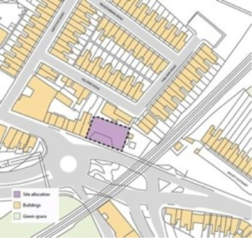
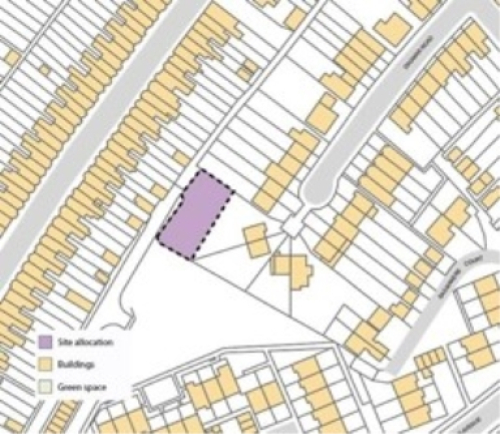
Site 7 - Bright Road
Existing use: Terraced garage block, accessed from Bright Road.
Availability & viability: mhs homes has pursued a programme to redevelop its redundant garage blocks for residential use in recent years. Examples within the Neighbourhood Area include Alfred Close and Cavalier Place. The site is in a poor condition, attracts anti-social behaviour and is vacant in part. It is therefore expected that the site will come forward for development within the plan period.
Site parameters:
- Site area: 0.07 hectares
- Indicative future use(s): Residential
- Indicative site capacity: 70-150 dwellings per hectare
- Maximum height parameter: 4 storeys (see Design Code)
- Flood zone: Low risk with a high risk of surface water flooding Land ownership: mhs homes
Key development principles: This site is suitable for terraced development of up to 4 stories (e.g. car-free mews with shared courtyard/garden). Access into the site should be focused from Bright Road although there is the opportunity to provide a pedestrian route through the site from Castle Road. This site could also provide the opportunity to improve the interaction between the site and the pedestrian footpath on the north east edge of the site as currently the garages create an inactive frontage.
Relevant planning history: N/A
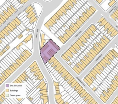
Site 8 - Dagmar Road
Existing use: Vacant land to the rear of 52 Dagmar Road. It is accessed via the service road off Shipwrights Avenue.
Availability & viability: The site has been subject to 5 planning applications between 2011 and 2019 (MC/11/1114, MC/15/0032, MC/16/4779, MC/17/1325 and MC/19/1599) and a dismissed appeal (APP/A2280/W/20/3251866). This demonstrates the availability of the site and the land owner's intention to develop it.
Site parameters:
- Site area: 0.049 hectares
- Indicative future use(s): Residential
- Indicative site capacity: 70-150 dwellings per hectare
- Maximum height parameter: 4 storeys (see Design Code)
- Flood zone: Low risk Land ownership: Private.
Key development principles: Proposals should consider the sloping nature of the site, upward towards Dagmar Road. The site is suitable for terraced development with access to the north west of the site via the service road. Outdoor amenity space should be located on the south- eastern edge of the site.
Relevant planning history: MC/19/2408 Construction of a terrace of four 3-bedroom houses with associated landscaping and parking. Refused at LPA and dismissed at Appeal as of 11th November 2022.