Hoo St Werburgh and Chattenden Neighbourhood Plan - Regulation 16
2. Background Information
2.1 The Area – Key Characteristics
Location and Population
The Parish sits on the Hoo Peninsula in the Greater Thames Estuary, which is one of the most important areas for birdlife in Europe. Located between the River Thames and River Medway, the Neighbourhood Plan area has rich heritage and historic assets. There is evidence of human activity in Hoo from Palaeolithic times.
The Parish of Hoo and Chattenden is located in the Medway Unitary Authority, set up in 1998 and administratively independent from Kent County Council, and is home to 13,782 people (2021 Census), compared to 8945 people from the 2011 Census and 7356 in total from the 2001 census. Table 1 gives more detail on the population. Expansion of the population has not been matched by the necessary expansion or improvement of transport and community infrastructure, including health and educational provision. This is a key concern for the local community, as discussed in 2.2.
Many more people are working from home, as a consequence of the COVID pandemic. It is unclear to what extent travel to work data will readjust in the future.
History
The Grade I listed Church of St Werburgh dates from the 12th century. Hoo St Werburgh has a long association with the armed forces, as demonstrated by the remains of the 17th century Cockham Wood Fort. Chattenden Army barracks date back to 1872. A narrow-gauge railway was built in 1873 to transport ordnance to Upnor. where it was stored for later use by the Royal Navy. In 1899 the Royal Ordnance Army Depot was built at Lodge Hill and the railway extended to Kingsnorth. Hoo was a centre for brickmaking in the 19th and early 20th centuries because of the brickearth found beneath the fields from Abbots Court to Chattenden. There is also a wealth of World War II heritage which is of local, national and international importance including the WWII Stop Line.
The parish formally changed its name from 'Hoo' to 'Hoo St Werburgh' on 1st October 1968.
Diagram 1: Hoo St Werburgh and Chattenden Parish Key Statistics (2021 census)
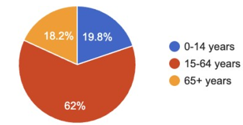
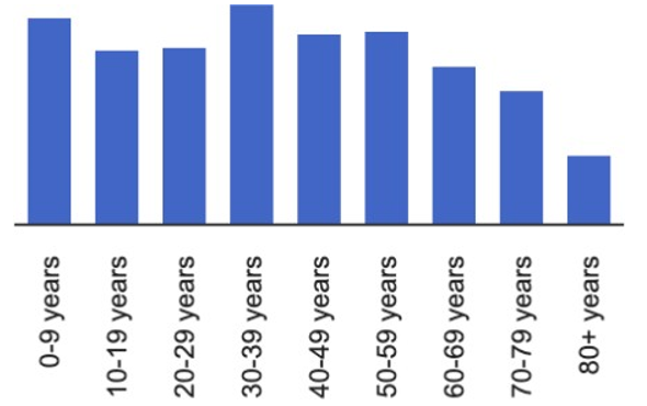
Hoo, St Werburgh – 2021 Census
|
Age Groups |
|
|
0-14 years |
2,252 |
|
15-64 years |
7,049 |
|
65+ years |
2,066 |
|
Age Distribution |
|
|
0-9 years |
1,539 |
|
10-19 years |
1,307 |
|
20-29 years |
1,318 |
|
30-39 years |
1,636 |
|
40-49 years |
1,411 |
|
50-59 years |
1,436 |
|
60-69 years |
1,188 |
|
70-79 years |
1,009 |
|
80+ years |
524 |
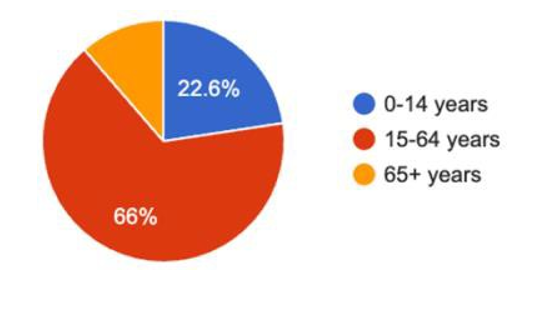
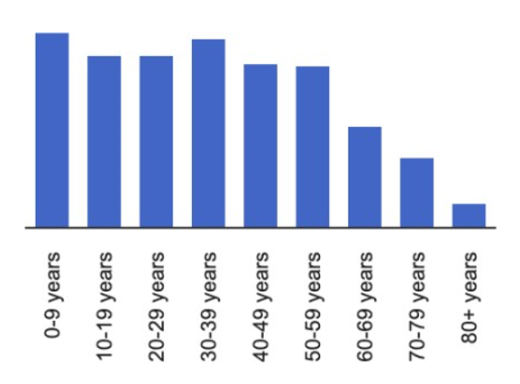
Chattenden–2021 Census
|
Age Groups |
|
|
0-14 years |
546 |
|
15-64 years |
1,595 |
|
65+ years |
274 |
|
Age Distribution |
|
|
0-9 years |
376 |
|
10-19 years |
331 |
|
20-29 years |
332 |
|
30-39 years |
365 |
|
40-49 years |
318 |
|
50-59 years |
311 |
|
60-69 years |
197 |
|
70-79 years |
138 |
|
80+ years |
47 |
2.2 Engagement with the Community
A number of community engagement activities and events were held in different areas of the Parish, in order to gain the views of local residents.
The Parish Council approached and engaged with a range of stakeholders including businesses, local services, health bodies, schools, consultants/developers, environmental groups, Homes England, and the local authority. This included in- person meetings. This was essential in informing the content of the Plan.
Meetings were held at various times of day at the local Church and the Village Halls in both Hoo and Chattenden. This included stalls at the Hoo Marina Summer Fayre and Christmas Fayre and in the village square (Saturday) to speak to shoppers. The local primary school provided written and illustrative feedback. A stand was also set up at the local secondary school during a year 7 open evening.
A leaflet was delivered to every dwelling in Hoo and the Plan was also publicised in the local village magazine.
Numerous residents responded and key concerns included:
- The local environment, including open space, wildlife and air quality.
- Housing requirements, including for first time buyers, older people looking to downsize, and extended families.
- The need to keep and expand on local community facilities, including sports facilities, and health and educational facilities to deal with an expanding population.
- Infrastructure, including the need for a new road to link the Peninsula.
- Village heritage and character.
- Lack of parking provision in new development.
- The need for more play and recreational facilities for children and youth.
These issues have informed the policies of the Neighbourhood Plan.
A number of non-planning matters were also raised, including concerns over policing and utilities. These comments have been brought to the attention of the relevant bodies.
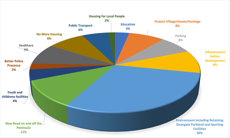
Diagram 2: Consultation Results (amalgam of all engagement activities)
The diagram shows predominant local concerns over environmental protection and community and transport infrastructure.
2.3 Liaison with Medway Council
The development of the Neighbourhood Plan has taken place during a period of great uncertainty in relation to local plan policy-making by Medway Council and has had to follow the Medway Council Local Plan review process (Medway Local Development Scheme October 2022). The Medway local plan has to take into account the needs of the whole of Medway and accommodate their duty to cooperate with other local authorities and service providers on issues like housing development, transport and health provision.
As far as possible the Parish Council and steering group have taken a flexible and positive approach to the development of the Medway Local Plan's emerging policies and their supporting evidence as the Neighbourhood Plan has developed and discussed its policies with Medway as part of the process. Medway's Local Housing Needs Assessment identifies a need for 1667 homes a year (March 2023). However, national Government is considering housing figures again, so this figure is likely to change.
Medway Council has declared a climate emergency. One of the Basic Conditions for Neighbourhood Plans is achieving sustainable development. Sustainability is a theme throughout the policies of this Plan. Climate change is address through policies on design, the natural environment, active travel, housing and a range of other policies that aim to support a mix of uses and local facilities (15-minute neighbourhoods).
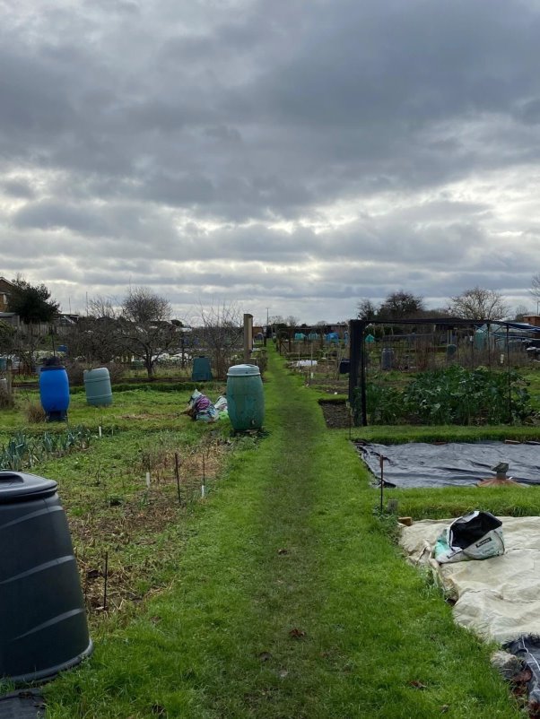
Allotments provide opportunities for local food growing.