Hoo St Werburgh and Chattenden Neighbourhood Plan - Regulation 16
6. Place and Heritage
Purpose
To protect and enhance the historic environment of Hoo and to ensure that new development is well-designed and sustainable.
Evidence and Planning Rationale
National Policy
Chapter 12 of the NPPF deals with 'Achieving well-designed places'. Design considerations include function, adding to the quality of the area, visual attractiveness, effective landscaping, being sympathetic to local character and history, not discouraging innovation and change, maintain strong and distinctive sense of place, optimise site potential, and making safe, inclusive and accessible places.
This is augmented by the National Design Guide (2021) which states that well- designed places have ten characteristics. These are context, nature, identity, use, resources, movement, built form, public space, homes and buildings, and lifespan.
Chapter 16 of the NPPF deals with 'Conserving and enhancing the historic environment'. This includes consideration of sustaining or enhancing heritage assets, wider social, economic and cultural benefits, contribution of new development, and character of place.
Local Policy
The Medway Local Plan 2003 contains various policies relating to design and the historic environment. These are now somewhat out-of-date due to the age of the plan, changes to national policy and guidance, the introduction of the National Model Design Code 2021, and the increasing priority given to climate change. However, many policies are still consistent with the NPPF and have been recognised as such by a number of planning inspectors in appeal cases.
Policy S2 (Strategic Principles) includes reference to design standards. Policy S4 deals with urban design, but in very vague terms.
Chapter 3 deals with the Built and Natural Environment. The most relevant policies are:
- BNE1 General Principles includes fairly general design requirements.
- BNE6 Landscape Design
- BNE28: Farm Diversification
The Neighbourhood Plan sets more specific design requirements and takes account of more recent guidance.
Other Documents
The Hoo St Werburgh Design Codes document prepared by AECOM (November 2021) has informed the design policy and its interpretation, and also later policies on landscape and transport.
The National Model Design Code and other guidance, including Building for a Healthy Life, have informed the following design policy.
Historic England's Hoo Peninsula Historic Landscape Report 2015 describes the local landscape, including military heritage.
Planning Background
Good design is fundamental to achieving sustainable development. Quality of environment is an important factor in creating places where people want to live, work, spend leisure time and invest.
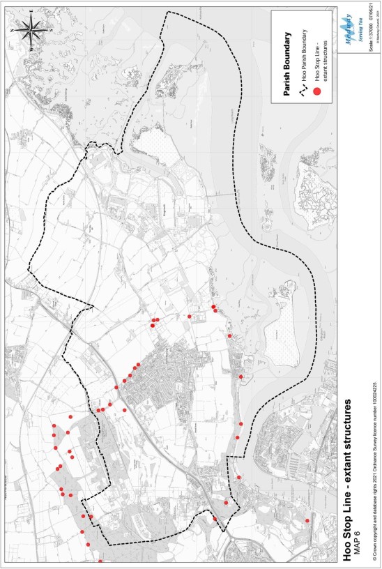
Hoo has a varied heritage, including the Grade I listed Church. Much heritage is in productive use. However, it is important to recognise the importance of heritage that can't be used, but is important for education and in attracting visitors. Hoo was declared a defended village during WW2 and a trench was dug from the river Medway to Cliffe with various pillboxes and road barriers to stop an overland invasion. The trenches have since been filled in but dozens of structures still remain. There is clearly potential for the Hoo Stop Line to be harmed considerably by ill- conceived development. This consideration is incorporated into the heritage policy. More detailed analysis is in the Hoo Peninsula Kent 2nd World War Stop Line, Hoo St Werburgh to Higham Marshes, 2014.
HOO6: Design
- Development must be well designed to create a sustainable and locally distinctive places, to complement Hoo's historic and rural character.
- To achieve this, new-build development must:
- Complement the predominantly 2-3 storey character of the area
- Complement the surrounding townscape in terms of scale, massing and degree of set-back of building frontages from the road;
- Provide active frontages (containing windows) facing public roads and spaces, to provide natural surveillance;
- Provide boundary treatments to road frontages to complement traditional boundary treatments, including low flint or brick walls and hedges.
- New-build development that creates new layout and public realm must:
- provide convenient, attractive and safe environments to support movement, recreation, social interaction, play and exercise for people with a range of mobilities;
- provide pedestrian links to surrounding paths and facilities, including public transport, and create good linkages within the site;
- Include a high-quality public realm (streets and other spaces), including landscaping, to support movement, social interaction and promote biodiversity.
- Development should incorporate positive design features to reduce carbon use, support biodiversity and address climate change.
- Building materials must have a high standard of finish and be durable to weathering and support will be given to the use of local and recycled materials or green materials.
- Hard surface ground materials should take account of the local context and be water permeable.
- Support will be given to innovative or creative design solutions that are designed for the specific site and context, especially where they offer superior environmental performance.
- Sustainable Drainage Systems (SuDS) should form an integral part of new spaces and green infrastructure, wherever possible.
Interpretation
The policy addresses character and sustainability, supporting green design in particular. The policy requires a holistic approach to design, with a focus not just on buildings, but in creating attractive places with a high quality of public realm. The policy should not be interpreted as requiring stylistic imitation or preventing high quality contemporary design.
Too often, designs are based on highway requirements, division into plots, standard house types and landscaping of leftover bits. Such an approach will not meet the requirements of the policy.
Active frontages could be created from use of windows, doors, balconies and other features. The design and access statement submitted with some planning applications provides the opportunity to explain how the requirements of the policy have been met.
Design of new public realm should include consideration of a diverse range of activities and accommodate different users. Development adjoining public open spaces and should enhance their character by providing positive building or landscape frontages.
Green design features to reduce carbon use could include:
- use of efficient heating and cooling systems, or design to reduce dependency on heating and cooling systems.
- superior insulation properties and airtightness;
- orientation to take account of climate;
- natural ventilation and air flow to help avoid over-heating in warmer weather;
- use of local, low-embodied energy, recycled and recyclable materials;
- living (green) walls or roofs as part of the design;
- rainwater capture, storage and reuse (grey water);
- inclusion of space for natural drying clothes;
- flexible spaces and layouts to accommodate changing demands;
- sustainable urban drainage systems (SUDS) incorporated into the landscape design;
- use of traditional hedges for boundary treatments, to create a greener environment;
- use of native species in planting;
- local green energy schemes such as ground heat pumps, photovoltaics, biomass and other technologies;
- micro-generation, including solar panels;
- reusing and retrofitting existing buildings to maintain the embodied energy used in their construction, whilst also avoiding landfill.
Even minor development can include features to reduce carbon use, for example in the careful choice and specification of materials.
The colour and finish of solar panels and how they reflect light should be chosen to fit in with the building or surroundings. The solar PV panels should be carefully positioned and laid out so that they are in proportion to the building and its features.
In designing public realm and paths, it is good practice to consider adaptation and resilience against extreme weather.
The Hoo St Werburgh Design Codes document prepared by AECOM (November 2021) and the National Model Design Code may be useful in securing compliance with the policy.
Water Infrastructure Guidelines
New and improved utility infrastructure is encouraged and supported in order to meet the identified needs of the community.
Southern Water recommends as a minimum the tighter Building Regulations optional standard for water efficiency of 110 litres per person per day.
Southern Water highlights opportunities provided by new developments and improvements in green and other infrastructure to reduce the causes and impacts of flooding (making as much use as possible of natural flood management techniques as part of an integrated approach to flood risk management). Well-designed sustainable drainage systems help to reduce the volume of surface water entering the foul sewer system – which could help to reduce localised flooding and, in turn, help to minimise pollution events. Sustainable drainage systems will therefore be key to helping neighbourhoods respond to the impacts of climate change into the future.
Southern Water has criteria for SuDS adoption, so early engagement with them is encouraged. Medway Council also has guidance on SuDS.
Southern Water advises the Local Planning Authorities to consult on all major development applications within its wastewater service area.
HOO7: Local Heritage
- Development should preserve or enhance and cause no harm to the character and significance of Hoo's industrial, military and war heritage, including the Hoo Stop Line and its historic structures, features and landscape.
- Development should seek to have no significant adverse impacts on non- designated heritage assets and their setting and should take opportunities to enhance them.
- The development and refurbishment of historic farmsteads will be supported, providing the scheme preserves or enhances their character and significance.
Interpretation
The policy protects designated and non-designated heritage and highlights the particular local and national importance of war-related heritage assets. The Hoo Stop Line includes listed structures and non-designated heritage.
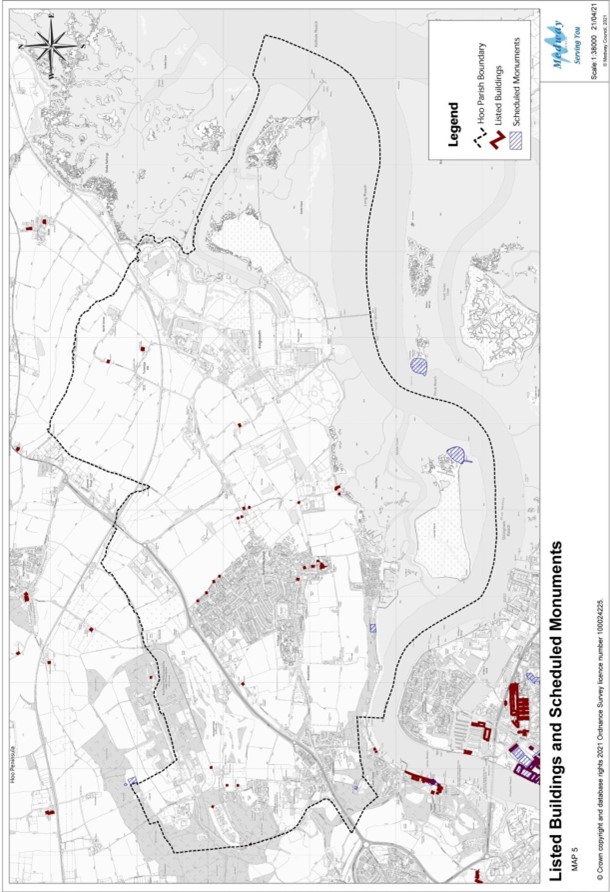
Listed Buildings and Scheduled Monuments
|
Site |
Heritage Category |
Location |
Grid Reference |
|
Church of St Werburgh |
Listing Grade I |
Church Street, Hoo |
TQ 78346 71856 |
|
War Memorial |
Listing Grade II |
Churchyard, Hoo |
TQ 78412 71906 |
|
Mill House |
Listing Grade II |
Ratcliffe Highway, Hoo |
TQ 76985 72772 |
|
Cold Arbour |
Listing Grade II |
Stoke Road, Hoo |
TQ 80723 74334 |
|
Meadow House |
Listing Grade II |
Main Road, Hoo |
TQ 78178 72128 |
|
White Hill House |
Listing Grade II |
Off of Stoke Road, Hoo |
TQ 80869 73931 |
|
Lancer's Farm |
Listing Grade II |
Jacob's Lane, Hoo |
TQ 79979 72809 |
|
Ivy House |
Listing Grade II |
Church Street, Hoo |
TQ 78334 72059 |
|
The Chequer's Public House |
Listing Grade II |
Church Street, Hoo |
TQ 78348 71962 |
|
Anti-tank Cubes on seawall |
Listing Grade II |
Hoo |
TQ79263 71678 |
|
Type 24 WWII Pillbox on seawall |
Listing Grade II |
Hoo |
TQ79187 71656 |
|
Type 28 WWII Pillbox on seawall |
Listing Grade II |
Hoo |
TQ79244 71695 |
|
Four Pillboxes |
Listing Grade II |
Off Bells Lane, Hoo |
TQ 78171 73110 |
|
Hoo Fort |
Scheduled monument |
Hoo |
TQ 79635 70293 |
|
Lodge Hill Anti-aircraft battery |
Scheduled monument |
Chattenden |
TQ 75850 74047 |
|
Cockham Wood Fort |
Scheduled monument |
Hoo |
TQ 77521 71236 |
|
Beaconand pillbox on Beacon Hill |
Scheduled monument |
Chattenden |
TQ 75781 71463 |
|
Building 67, WWI Sentry Box, Lodge Hill |
Listing Grade II |
Lodge Hill, Chattenden |
TQ 76017 73140 |
|
Building 106, Sentry Post, Chattenden Ordnance Depot |
Listing Grade II |
Lodge Hill, Chattenden |
TQ 75127 72684 |
|
Building 127, WWI Sentry Post, Chattenden Ordnance Depot |
Listing Grade II |
Lodge Hill, Chattenden |
TQ 75562 73121 |
|
Two WWI Sentry Posts |
Listing Grade II |
Lodge Hill, Chattenden |
TQ7581072831, TQ7581372964 |
|
Pair of WWII concrete road block plinths |
Listing Grade II |
East of Hoo St Werburgh |
TQ7890672826 |
|
Type 24 WWII pillbox |
Listing Grade II |
East of Hoo St Werburgh |
TQ7892472786 |
|
Type 28 WWII pillbox |
Listing Grade II |
In the garden of Abbots Court Lodge, Hoo St Werburgh |
TQ7901672758 |
|
Type 24 WWII pillbox |
Listing Grade II |
South of Abbots Court Lodge, Hoo St Werburgh |
TQ7903172699 |
|
Type 24 WWII pillbox |
Listing Grade II |
South of Abbots Court Cottages, Hoo St Werburgh |
TQ7908872125 |
Source: Historic England (2022)
Buildings of local interest (non-designated)
- The Five Bells public house, Village Centre;
- Library (originally a school built in 1894), Church Street, Hoo;
- Yew Tree Lodge Residential Care Home (originally a school built in 1875), Stoke Road, Hoo;
- Former National School Building in Church Street (c. 1836);
- Old bomb disposal buildings at Lodge Hill;
- Hoo Institute, Main Road;
- Windmill former Pub (health centre), Ratcliffe Highway and surrounding fields;
- Millers Cottage, Ratcliffe Highway;
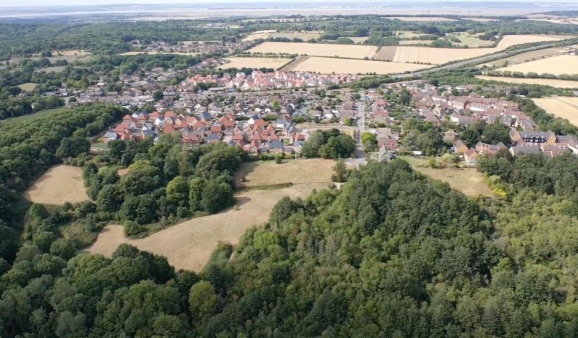
Aerial view of Chattenden and Hoo Common.