Hoo St Werburgh and Chattenden Neighbourhood Plan - Regulation 16
7. Landscape and Natural Environment
Purpose
To protect and enhance the area's rural and natural environment, landscapes and biodiversity.
Evidence and Planning Rationale
National Policy
Chapter 15 of the NPPF deals with 'Conserving and enhancing the natural environment'. Planning policies should protect and enhance valued landscapes, intrinsic character and beauty of the landscape, habitats, and provide net gains in biodiversity. This includes consideration of protection of valued landscapes, intrinsic character, biodiversity net-gain, pollution, mitigation.
Chapter 8 of the NPPF deals with 'Promoting healthy and safe communities' including supporting healthy lifestyles and shared spaces. Local Green Space criteria for designation is dealt with in Paragraphs 100-103.
Local Policy
The Medway Local Plan 2003 contains a wide range of policies relating to the natural environment and open spaces. These are now somewhat out-of-date due to the age of the plan, changes to national policy and guidance, a range of environmental legislation and the increasing priority given to biodiversity and climate change. However, many policies are still consistent with the NPPF and have been recognised as such by a number of planning inspectors in appeal cases.
Policy S4 deals with landscape mitigation. Chapter 3 deals with Landscape and the Built Environment. This includes:
- BNE6 Landscape Design
- L3: Protection of Open Space
There is a range of other landscape policies, dealing with different landscape types. The Neighbourhood Plan seeks to localise landscape protection and also to designate Local Green Space.
Other Documents
Detailed analysis of these spaces is contained in the Hoo St Werburgh Local Green Space Analysis Report 2022.
The Hoo St Werburgh Design Codes document prepared by AECOM (November 2021) has informed the Landscape and Environment policy and its interpretation.
Planning Background
Hoo St Werburgh and Chattenden Neighbourhood Area is characterised by its attractive, distinctive estuarine, woodland and farmed countryside that holds a rich diversity of wildlife. The Hoo Peninsula is highly prized for the beauty of its natural environment and it contains habitats, including for some of the most threatened and vulnerable species in the UK, and fauna and flora of international importance.
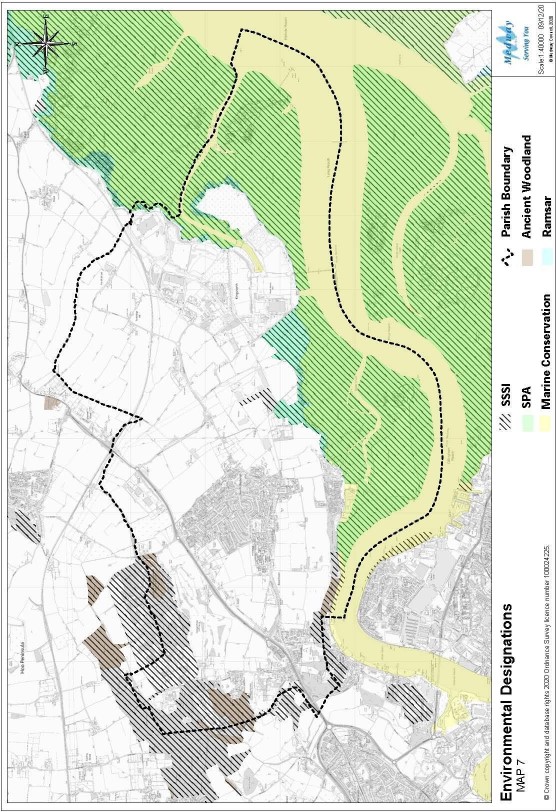
The Medway Estuary and Marshes is a site of international importance for birds and other wildlife and recognised as a SSSI, Special Protection Areas (SPA) and Ramsar sites (Wetland bird habitats of global importance). The Hoo environs comprise fresh- water marshes, inter-tidal flats and saltmarshes.
Spaces that have special community value and meet the NPPF criteria for Local Green Space designation are:
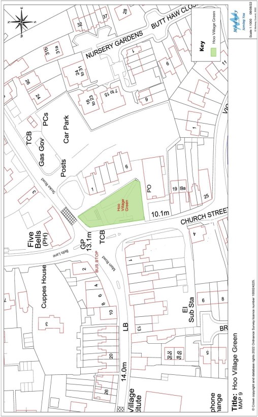
- Village Green - a 1.0-acre green and landscaped area located in Church Street, managed by Medway Council.
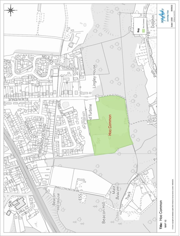
- Hoo Common - located off Elm Avenue, this is a large sloping site which includes woodland walks, meadows and open space surrounded by dense treeline.
Hoo St Werburgh is the larger settlement, with a range of community facilities. Chattenden is a hamlet and largely residential. Chattenden Valley is an important green corridor between Hoo St Werburgh and Chattenden. It forms a corridor for wildlife and maintains the distinctive identify of the two settlements. It allows views of the hills, woodlands, river, open farmland and marshes.
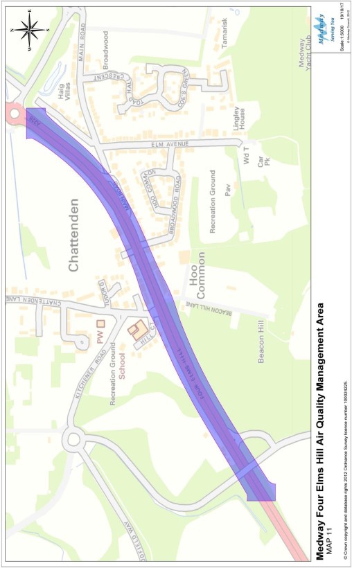
Air quality is a particular issue around Peninsula Way/Four Elms Hill, which is subject to air quality monitoring (Air Quality Management Area - AQMA).
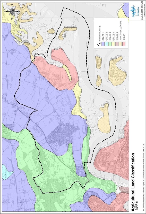
The area has a strong farming heritage, and much farmland comprises the 'best and most versatile' (Grades 1, 2 and 3A). There are orchards and farming for various food crops. All these resources are important as a national resource which continues to contribute to food security and biodiversity.
Hoo St Werburgh and Chattenden Parish should continue to operate as a green lung for Medway, enhancing and conserving rural views and landscape, wildlife sites and corridors, agricultural land and opportunities for recreation.
HOO8: Landscape and Environment
- Development should take opportunities to enhance and avoid causing significant harm to the area's landscape character, flora and fauna, and habitats, and seek to achieve overall biodiversity net gain.
- Development should avoid causing loss or harm to biodiversity, or:
- where habitat loss or damage cannot be avoided, it should be minimised;
- opportunities should be taken to restore damaged or lost habitat; or
- as a last resort, habitat loss or damage should be compensated.
- Development should take opportunities to enhance and should not harm:
- Designated sites, including Ramsar, SSSI and Special Protection Area;
- local woodlands, including ancient woodland;
- lakes, chalk streams and other water features.
- Development adjacent to the Ramsar, Special Protection Area, SSSI and other designated and protected landscapes should include landscape buffer zones, where supported by evidence, to provide visual separation and avoid disturbance of habitats or adverse impacts on biodiversity.
- Trees and other natural features of value should be retained and be incorporated into the design and layout of development.
- Development that creates a new urban edge to the open landscape areas of Hoo should include landscape transition zones to avoid the creation off hard edges.
- Development should cause no harm to the open character of the landscape separation between Hoo and Chattenden.
- Landscape design and planting in development should use local native species or other species of high environmental value.
- Development should take opportunities to enhance wildlife and nature conservation.
- Development should have no adverse impact on allotments, orchards and other facilities for local food growing, and new facilities for local food growing will be supported.
- Development should not lead to the loss of the best and most versatile agricultural land.
Interpretation
The policy recognises the landscape character of the area and the importance of landscape design in new development.
Incorporating existing landscape features, landform and green infrastructure into redevelopment is an important part of avoiding habitat damage.
In terms of impacts on habitats, the following hierarchy should help in securing compliance with the policy:
- Avoid habitat damage;
- Minimise habitat damage;
- Restore damaged or lost habitat;
- Compensate for habitat loss or damage (as a last resort).
Design features to support wildlife could include:
- Swift and other bird boxes, owl holes and bat bricks;
- Hedgehog gaps in fences;
- Badger routes;
- Wildlife connectivity via grass verges and footpath edges;
- Meadow edge grasses and wildflowers;
- Planting late, mid-season and early blooming nectar rich flowers to attract pollinators and beneficial insects all year round;
- Log and stone piles for invertebrates, toads and slow worms.
Landscape transition zones could comprise trees and hedges as boundary treatments, together with other planting using local native species.
In securing compliance with the policy, the design process should take account of:
- The particular characteristics and landscape qualities of the area, including landscape designations;
- In rural locations, impacts on the character and tranquillity of the area;
- Existing views, which should be incorporated into the design;
- The importance of amenity space within the scheme, which can draw on local landscape characteristics.
- Opportunity to open up access to the countryside.
- Opportunities to link new paths and green spaces with existing networks of green space, including wildlife corridors.
- Opportunities to use SuDs schemes to augment landscape and biodiversity.
The Forestry commission has guidance on suitable trees for addressing climate change. Please see link: https://www.forestresearch.gov.uk/tools-and-resources/fthr/tree-species- and-provenance/
HOO9: Local Green Space
- The following spaces are designated as Local Green Space:
- LGS1: Village Green, Church Street
- LGS2: Hoo Common, Elm Avenue
- Development must have no significant adverse impact on, and take opportunities to enhance, the open and green character, amenity, safety, accessibility, or community value of Local Green Space.
Interpretation
The policy protects Local Green Spaces, with similar protection to green belts (though it should be noted that the purpose of LGS designation is quite different to that of green belts).
The policy also recognises that adjacent development can impact on Local Green Spaces and requires careful consideration of such impacts.
HOO10: Air Quality
- Development should not significantly exacerbate pollution in areas with recognised air quality problems.
- Development that is likely to result in significant negative impacts on air quality, including through generation of additional vehicle movements, should include tree planting or other measures to mitigate impacts on air quality.
Interpretation:
The policy augments and localises national and local policies relating to air quality. Areas with recognised air quality problems would include those subject to air quality monitoring, such as Four Elms Hill/Peninsula Way.
Medway Council's Air Quality Planning Guidance, March 2016 (Revised November 2021), should be helpful in securing compliance with this policy.
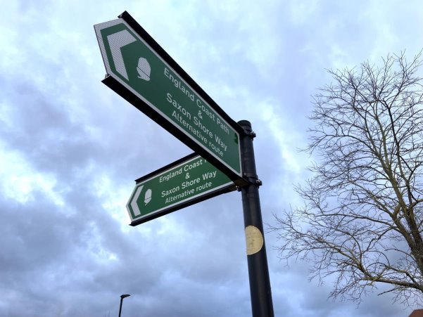
The England Coastal Path runs through the parish