Hoo Development Framework
2| Context Analysis
2.1 Regional Context
Medway lies within the heart of the Thames Gateway, approximately 50km from Central London. It is very well connected by road with the M2, and by rail with the high speed connection between London St Pancras and Ashford International and east Kent, in addition to the services on the main North Kent line. However some of these transport networks have capacity pressures.
Medway is the largest urban agglomeration between London and mainland Europe, reaching 280,040 people in 2020.
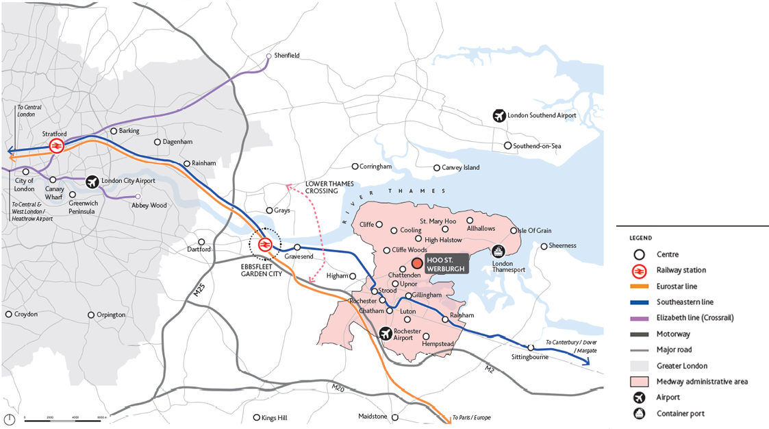
Medway is at the heart of a rapidly changing growth corridor in the Thames Estuary extending from Greater London to the South East - ongoing infrastructure investment and major projects such as Ebbsfleet Garden City, Lower Thames Crossing and Crossrail continue to shape the region. Medway shares the wider ambitions for attracting investment and boosting the economy. Its regeneration strategy builds on the success of areas such as Chatham Maritime, following the closure of the dockyard in the 1980s. It benefits from the Universities at Medway and colleges providing a skilled workforce, and has exceptional regeneration opportunities with strong heritage links and countryside and coast on the doorstep of the urban communities.
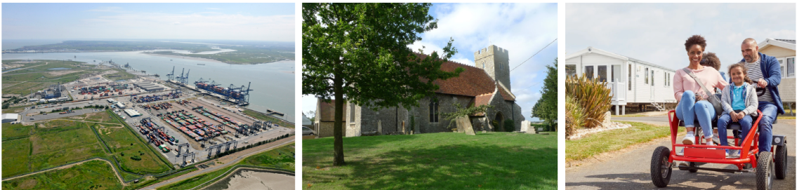
The Hoo Peninsula is of long standing strategic importance, particularly for infrastructure. Its estuarine location and relative remoteness have supported the development of wharves and power plants, of regional and national significance for energy and aggregates. The marshes and mudflats along the Thames and Medway form part of wider environmental assets across the Thames Estuary Corridor, of international importance for wildlife. Long term investment in the upgrading of transport links on the Hoo Peninsula will also greatly enhance connectivity from within Medway to surrounding regions.
2.2 Medway Context
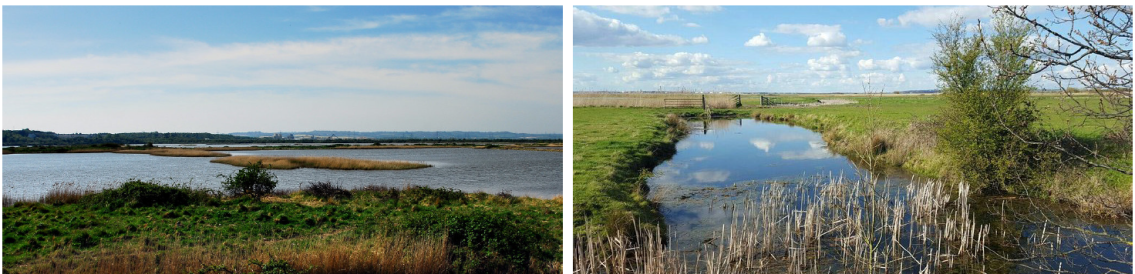
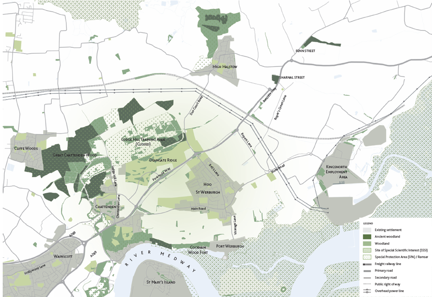
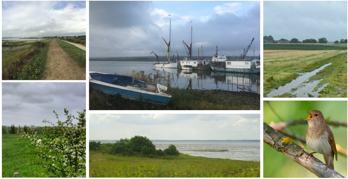
Medway is a largely urban authority by population - the majority of residents live in the historic towns between Strood and Rainham, that are now closely connected. However much of the land mass is rural, to the north of the Medway on the Hoo Peninsula, and to the south in the Medway Valley. There is a distinct separation between built up urban Medway and the countryside and small villages on the Hoo Peninsula. The Hoo Peninsula is a more remote location in terms of accessibility, with fewer and smaller settlements and a preserved landscape. There are traces of the area's past settlements and industries in its historic landscape. The River Thames wraps around the northern edge of the Peninsula creating an important wetland and marshland habitat. The natural environment in Medway consists of a wide range of different landscape types, ranging from coastal marshes, chalk downland and orchards to large scale arable farmland and extensive woodland, some of which support nationally significant populations of Nightingales. It includes environmental designated areas such as nationally important Sites of Scientific Interest (SSSI), Special Protection Areas (SPA) and Ramsar sites, of international importance for migrating birds, but also countryside that is strongly influenced by built developments and urban fringe pressures.
Medway is a diverse area, with pockets of deprivation close to affluent communities; outstanding heritage, but with some areas marked by economic decline and poor quality development. It plays an important economic role, but also has a high degree of out commuting. The retail and commercial offer reflects the historic development of the separate towns, with services located in different High Streets and retail centres. Medway benefits from very good rail services between its urban centres with Strood, Rochester, Gillingham, Rainham and Chatham connected by the High Speed train connection. However, Hoo St Werburgh remains isolated with difficult connections with the rest of Medway. Strood station is located 4.5 miles southwest of Hoo St Werburgh and is reachable by bicycle in around 27 minutes via the steep topography of Four Elms Hill, while the car journey takes 12 to 15 minutes. There are limited crossings over the River Medway, at Rochester Bridge and the Medway Tunnel, which is closed to pedestrians and cyclists. Few bus routes with a low frequency connect Hoo St Werburgh to the other urban centres, making it difficult and costly for many residents of the Peninsula to use public transport.
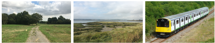
The existing freight rail line to the north of Hoo St Werburgh runs between Gravesend and the Isle of Grain employment areas. The potential for this railway line to be upgraded to a passenger line is one of the new major transport schemes being delivered through the HIF programme. The new link and railway station could greatly improve the transport connectivity and have a significant positive impact on the local economy.
Residents of the Peninsula strongly value its rural character, that makes it distinctive from urban Medway, and do not want to lose this. However the Peninsula has a limited service offer, and residents do look to urban Medway, and beyond, for many services, education and work. It is essential that transport links are effective, but that future development avoids coalescence with urban Medway. The Hogmarsh Valley has an important role as a strategic gap and green infrastructure asset.
The expansion of Hoo St Werburgh would require a major upgrade of the transport networks through the introduction of additional bus services and routes, and better pedestrian accesses and cycle lanes. The re- introduction of a passenger railway connection to the Peninsula would be a great benefit to the sustainability of transport links to and from the Peninsula.
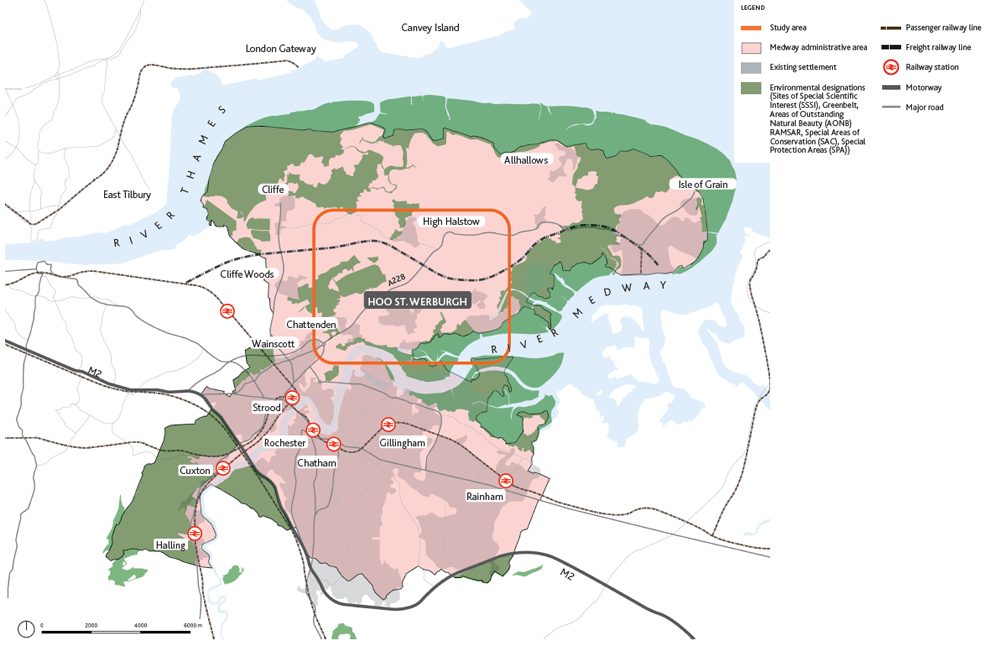
2.3 Hoo Peninsula Context
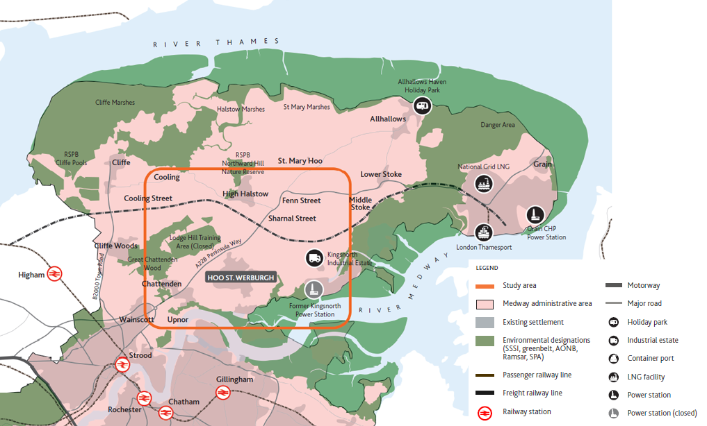
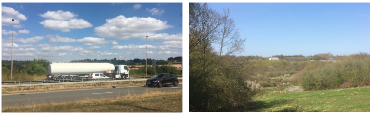
The Hoo Peninsula has been shaped by geography and history to provide the distinctive characteristics we can see today. The spur of land projects from north Kent between the Thames and Medway, with the main transport links running in a narrow corridor to the south west. The edges of the Peninsula are marked by remote marshes and mudflats, with major infrastructure installations at key points, such as Kingsnorth, Cliffe and the Isle of Grain. The wooded ridge running through the centre of the Peninsula includes some of the important wildlife sites. The area has contrasting strategic functions for infrastructure and the natural environment. It is also a farmed landscape, and agriculture and horticulture are major land uses.
Further strategic guidance for the protection and enhancement of the natural environmental assets on the Hoo Peninsula are set out in the Medway Green and Blue Infrastructure Framework.
There are a number of small villages across the Peninsula, with the large village of Hoo St Werbugh providing wider, but limited services, for the smaller villages. Many villages expanded rapidly in the post war period with the development of the power stations.
The post war power stations have been de-commissioned, but the area remains important for energy supply and transportation. Former sites are being redeveloped and logistics are a major sector, such as areas around Kingsnorth.
The Peninsula is in yet another phase of change, with the large former power plant sites finding new uses, including more sustainable energy options, as the country responds to the climate emergency and moves to meeting net zero carbon commitments.
The villages have also seen more housing development in recent years, in common with other parts of Medway and wider Kent. Levels of housing need have risen dramatically in the South East, and Medway has to plan for how it can best accommodate this need for new homes up to the late 2030s. These pressures will bring further changes to the Hoo Peninsula.
2.4 Local Context
Hoo St Werburgh, generally known as Hoo, is located in the Hoo Peninsula, to the north east of urban Medway. It is the largest settlement on the Peninsula, with a population of about 9,000 residents (2011 Census) and acts as a service centre for smaller villages on the Peninsula. The small town provides various social and community facilities including a secondary school, a number of convenience stores and other small-scale shops in the village centre, and health facilities.
Hoo St Werburgh is connected to urban Medway via Peninsula Way (A228) and to the M2/A2 via the A289, providing access to the wider Kent area and London.
The landscape around Hoo St Werburgh is diverse with protected areas, fields, woodlands and scattered villages. The area's heritage has particular significance for military and industrial history over many centuries. Assets such as the Hoo Stop Line are key features in the local environment. The south of the Peninsula accommodates some large scale commercial and industrial uses including Kingsnorth Commercial Park and London Thamesport further east.
2.5 Landscape Character and Sensitivity
This section sets out an overview of landscape character and sensitivity as part of the contextual analysis of the study area. There is marked variation across the area and the analysis is presented in ten separate character areas.
The present assessment of the sensitivity of the landscape to change is based upon an evaluation of published landscape character assessments, site visits, desk based studies and Medway Council landscape advice. It is beyond the scope of the Hoo Development Framework to deliver a comprehensive appraisal of the landscape sensitivity of the setting of Hoo St Werburgh and as such, appropriate studies should also be read in conjunction with this report. The table below sets out the landscape sensitivity criteria used in this assessment:
|
Sensitivity |
Definition |
|
LOW |
The land parcel can accommodate the proposed development without significant character change. |
|
LOW / MEDIUM |
The land parcel can accommodate the proposed development in many situations without significant character change. |
|
MEDIUM |
The land parcel can accommodate the proposed development in some situations without significant character change. |
|
MEDIUM / HIGH |
The land parcel can accommodate the proposed development only in limited situations without significant character change. |
|
HIGH |
The land parcel is unable to accommodate the proposed development without significant character change. |
Figure 2.16 Landscape sensitivity definition table
Much of the contextual information is taken from work on a Hoo Peninsula Landscape Sensitivity and Capacity Study. Considered design responses are subject to wider assessments and links to other programmes. Information is presented here as context for the preparation of the Hoo Development Framework.
1. Hogmarsh Valley
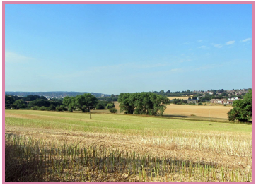
Figure 2.18 Hogmarsh Valley
A broad valley with open, gently rolling arable farmland and distinctive elevated woodland backdrop, the Hogmarsh Stream flows along the valley floor and includes small pockets of marsh.
Sensitivity to development : MEDIUM / HIGH
Potential design responses being considered include:
- Enhance Hogmarsh Stream as a distinctive landscape feature and as a link between settlement and wider countryside.
- Retain agricultural uses and soften and screen urban fringe pressures.
- Realise 'gateway' potential of the Hogmarsh Valley at key arrival nodes such as Four Elms roundabout through landscape enhancements and improved boundary treatments.
- Maintain an attractive and valuable buffer separating the more densely occupied urban areas to the south west from the quieter and more remote outlying settlements along the estuary and across the wider Hoo Peninsula.
2. Bald Top Hill
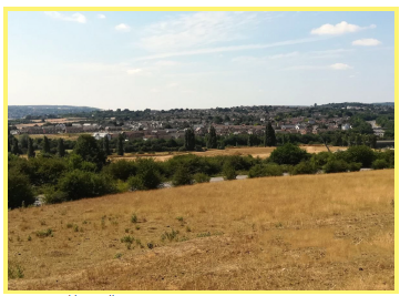
Figure 2.19 Bald Top Hill
Prominent farmed hill with a distinctive pastoral landscape and a quiet and unspoilt rural character. Dramatic long views from plateau to south over Medway Towns, estuary and towards North Downs. Includes tract of SSSI designated land to south east and ancient woodland, which acts as a carbon sink, particularly for the nearby traffic dominated Four Elms Roundabout.
Sensitivity to development: MEDIUM / HIGH
Potential design responses being considered include:
- Protect open and generally unspoilt character, development would not be appropriate on hill slopes or ridge.
- New development proposals should seek to enhance the green infrastructure opportunities to maximise benefit from this tranquil and remote area with outstanding views.
- Strengthen 'gateway' potential of Bald Top Hill as key gateway to the Hoo Peninsula and Medway.
- Protect the open and unrestricted views and rural character.
3. Chattenden Ridge
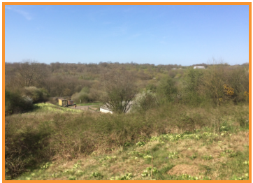
Figure 2.20 Chattenden Ridge
Prominent steep wooded ridge with open farmed land at its eastern extent, dropping down to a broad valley bottom at Lodge Hill; former golf course on the southern boundary defined by wooded fringe. Includes extensive tracts of designated land such as SSSI and blocks of ancient woodland, which acts as a carbon sink. Water is also a strong landscape feature running through the site.
Sensitivity to development: MEDIUM / HIGH
Potential design responses being considered include:
- Protect the wooded ridgelines and farmed slopes from harmful development.
- Sensitively balance between wildlife and community for mutual benefits.
- Enhance access to maximise its high recreational value having the highest point on the Peninsula.
- Development should respect the sense of place, tranquillity and distinctive rural character of the Chattenden Ridge.
- Development proposals should respect and conserve the role, function and extent of the ecological and cultural designations present across the ridge.
4. Deangate Ridge
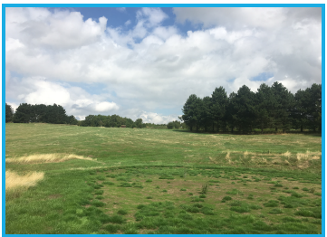
Figure 2.21 Deangate Ridge
Elevated ridge consisting of undulating arable farmland of a medium scale, area includes a number of disused recreational land uses. Includes some distinctive hedgerows and woodland blocks worth preserving. The western and eastern ends are subject to urban fringe pressures with a major road bisecting the landscape character area.
Sensitivity to development: MEDIUM
Potential design responses being considered include:
- Development should respect and preserve the 'green backdrop' function in strategic views the ridge performs.
- Ensure a substantial swathe of open countryside is retained to the west of the parcel to provide a green buffer.
- Enhance access and green infrastructure across the parcel.
- Protect and enhance the network of hedgerows, tree plantings and woodland located on settlement fringes.
- Proximity to Chattenden Woods and Lodge Hill SSSI and appropriate offsets to preserve the purpose of designation should inform the type and scale of development under consideration.
5. Hoo Farmland
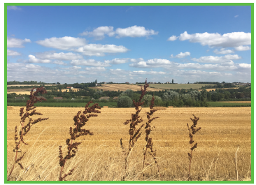
Figure 2.22 Hoo Farmland
Undulating, arable farmland with large fields, a fragmented network of hedgerows and sparse tree cover, road corridors are a source of severance within the landscape and are a general detractor.
Sensitivity to development: MEDIUM
Potential design responses being considered include:
- Maintain separation and openness between rural settlements.
- Protect the hedgerow network and provide a strong green buffer west of the parcel.
- Strengthen road corridor vegetation along both sides of A228 to ensure multi-functional benefits including wildlife corridor, reduction in adverse effects of noisy and polluting road network and softening, screening potential future developments.
- Maximise potential of water including opening up and realigning the watercourse to improve benefits of Green Infrastructure, flood alleviation and recreational opportunities.
- Development should respect and conserve the rural character, ecological value, tranquillity and distinctive identity of the farmland.
- Protect views of Deangate Ridge and estuary.
6. Cockham Farm Ridge
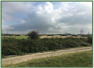
Figure 2.23 Cockham Farm Ridge
The Cockham Farm Ridge consists of two contrasting land uses, a distinctive and prominent wooded ridge and large undulating, open arable farmland on a valley slope. Performs an important functional role in retaining separation between settlements at Upnor, Hoo St Werburgh and Chattenden. Includes SSSI, Ancient Woodland, Ministry of Defence (MOD) land at Beacon Hill, recreational uses to west (Hoo Common).
Sensitivity to development: MEDIUM / HIGH
Potential design responses being considered include:
- The ridge is a prominent and distinctive feature within the landscape, development should respect and conserve its character and recognise its value as a 'green backdrop' in strategic views.
- Retain rural character and introduce open space facilities as part of a wider Green Infrastructure network.
- Strengthen field boundary planting , particularly along the Saxon Shore Way and conserve protected woodland areas.
- Maintain strategic open view across the Peninsula and estuary.
7. Hoo Flats
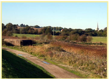
Figure 2.24 Hoo Flats
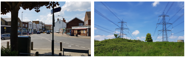
Low lying reclaimed marshland area with remnant features including creeks and ditches. Influenced by urban and industrial uses including power station, pylons, sewage works with adverse effects. Medway Marshes considered highly sensitive with several designations including Ramsar, SPA and SSSI. Provides long views across estuary.
Sensitivity to development : HIGH
Potential design responses being considered include:
- Area is largely inappropriate for built development due to low lying land.
- Introduce a wetland park to manage and protect dramatic estuary views, the sensitive and valued landscape and expand biodiversity.
- Protect strong sense of place along estuary shoreline and within hinterland areas.
- Strengthen and retain natural and heritage features of area.
- Enhance Green Infrstructure opportunities including connections into the wider landscape.
- Support public access to highly valued landscape area while ensuring ecological designations are protected from recreational disturbance.
8. Land East of Hoo St Werburgh
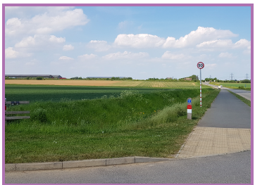
Figure 2.25 Land East of Hoo St Werburgh
Undulating, predominantly arable farmland with large open fields and little sense of enclosure, extensive views from higher ground towards estuaries. A freight rail line and a watercourse follow the valley floor while the land rises gently on either side to the east and west.
Sensitivity to development: LOW / MEDIUM
Potential design responses being considered include:
- Development should utilise appropriate green buffers to integrate schemes with the wider landscape.
- Maximise opportunities of local assets within design proposal including existing field patterns, water body, heritage assets and views of estuary.
- Development should protect the separation of, rural character and open countryside between rural settlements.
- Strengthen and increase the landscape structure and biodiversity value through the development and implementation of a Green Infrastructure strategy.
9. Land South of High Halstow
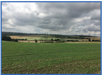
Figure 2.26 Land South of High Halstow
Undulating, predominantly arable farmland with large open fields and little sense of enclosure, extensive views from higher ground towards estuary and beyond. Distinctive features along the valley floor to north of A228 include natural water courses, overhead power lines, freight rail line, fruit packing stores and farmsteads.
Sensitivity to development: MEDIUM
Potential design responses being considered include:
- Development should utilise appropriate green buffers to integrate schemes with the wider landscape.
- Improve access to maximise cycling/walking opportunities and views.
- Development should protect the separation of, rural character and open countryside between rural settlements.
- Strengthen and increase the landscape structure and biodiversity value through the development and implementation of a Green Infrastructure strategy.
10. Land East of High Halstow
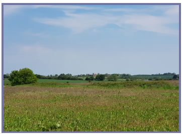
Figure 2.27 Land East of High Halstow
Tranquil and remote open farmed landscape predominantly in arable use with rural feel. Land to east performs important functional role in retaining separation between St Mary Hoo and High Halstow. Land to south east also functions as a buffer between enlarged High Halstow and Sharnal Street ribbon development.
Sensitivity to development: MEDIUM
Potential design responses being considered include:
- Maintain separation and openness between rural settlements.
- Development should respect and conserve the rural character, ecological value, tranquillity and distinctive identity of the farmland.
- Encourage green infrastructure and ensure access for the wider community to the area with outstanding views.
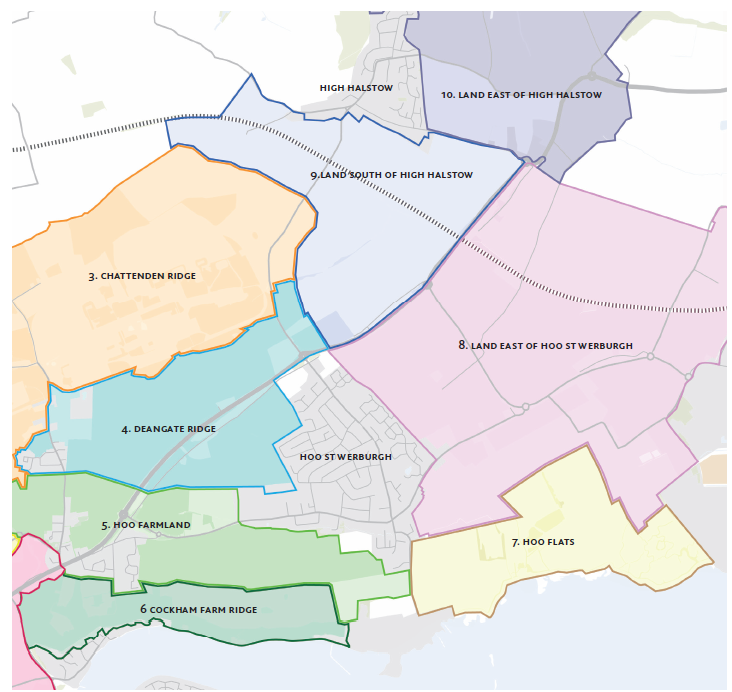
Figure 2.27 Landscape sensitivity definition diagram
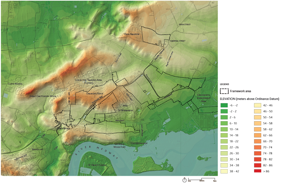
2.6 Topography
The area being considered in this Framework is formed of a complex landform of hills and valleys extending east and north-east, from elevated land to the west of Chattenden. This includes the Cockham Farm ridgeline at 45m AOD, the Deangate Ridge at 70m AOD and the Chattenden Ridge at 70m AOD. As a result, the western part of the site is part of a valley system, enclosed by these ridgelines, with the valley floor consisting of an unnamed stream to the east of the A228 at 25m AOD. The combination of these elevated ridgelines and existing woodland visually screen the lower parts of the western part of the site from the wider landscape, with only the more elevated parts of the site being visible from the south of the River Medway.
In contrast, the eastern and south-east parts of the site, are primarily flat or gently sloping landform falling from 40m AOD adjacent to the A228 to 15m AOD at Stoke Lane. From Stoke Road the landform falls to 5m AOD adjacent to the flats and marshes.
The initial masterplanning work in this document has considered topography and the impacts to visibility and visual characteristics that arise from it.
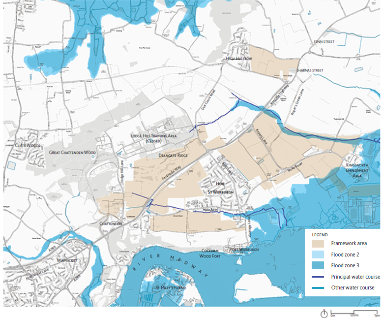
2.7 Water and Flood Risk
The area around Hoo St. Werburgh is predominantly rural, and the wider catchment contains a complex network of sub catchments and land drains which drain surface water out to the tidal Medway via the farmland and marshland situated within the lower reaches of the catchment. Parts of the Hoo St. Werburgh study area to the south and east are within the Medway Estuary and Marshes Site of Special Scientific Interest (SSSI), Special Protection Area (SPA) and Ramsar designations. The southwest of the study area is part of the Tower Hill to Cookham Wood SSSI (see the next page of the report for further detail). This, alongside the requirements of the Water Framework Directive, increases the importance of the need to ensure the discharge of clean, uncontaminated surface water.
The Hoo Stream is a key ordinary watercourse which passes through the main village. The stream commences at the Ratcliffe Highway and passes through the rear of properties at Main Road, with several culverted sections, before joining the Medway near Abbots Pools. There are two further ordinary watercourses in Hoo St. Werburgh; one flowing southeast from the Abbots Court area to the Medway, and the other flowing east along the northeast edge of the study area. There are currently three attenuation basins within the Hoo St. Werburgh area, with around five further attenuation ponds proposed within current planning consents.
There is a Southern Water public sewer network consisting of foul / combined and surface water sewers throughout the study area. The surface water sewer has several outfalls, discharging into different points along Hoo Stream, the River Medway and a storage pond east of Hoo St. Werburgh. The foul / combined network is pumped out of the study area by two pumping stations, one east of Hoo St. Werburgh and one in the southwest of the study area. There are no Combined Sewer Overflows (CSO) within the study area.
The majority of the areas around Hoo St Werburgh lies within Flood Zone 1, the lowest risk and most suitable areas for residential development.
The parts of the land identified for future growth located in Zones 2 or 3 (to the south-west) which are considered in this Framework, could accommodate open space and ecological enhancements associated with the marine environment of the river.
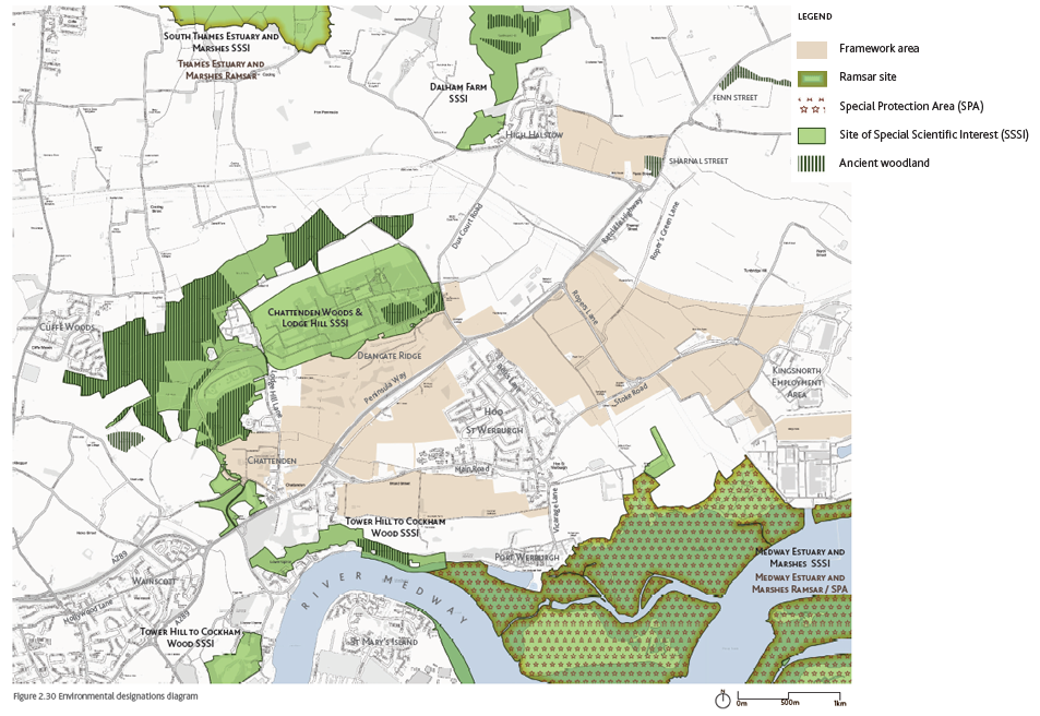
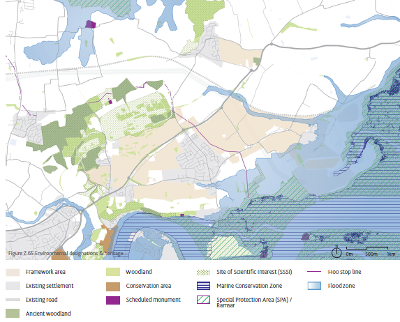
2.8 Environmental Designation Areas
Hoo Peninsula and its environs support a diverse range of valued habitats and cultural assets. Ecological designations of national and international importance are located to the north, west and south of the potential development area, most significantly within the Medway Estuary and Marshes.
A significant proportion of the estuary and marshes that surround Hoo are designated as Ramsar, SPA and SSSI, the closest located to the south of the potential development area. The SSSIs of Tower Hill to Cockham Wood and Chattenden Woods and Lodge Hill in addition to the pockets of ancient woodland situated within their limits are located to the north and west.
In developing this framework, the highest regard has been had for SSSI, Ramsar and SPA designations, their significance internationally and the ecological, biodiversity assemblages that they support.
2.9 Existing Vehicular Movement
Car ownership and usage rates on the Peninsula are much higher than the rest of Medway. This pattern reflects the rural location and could be influenced by the poor connection of the Peninsula with the rest of Medway - the public transport offer is unattractive to many residents, the topography is difficult for cyclists and the lack of cycle lanes and attractive pedestrian links make it very difficult and inconvenient for residents to use other transport modes than the car. Residents want transport options, and policies to address climate change require more sustainable alternatives to the car.
Road Network
The A228 - Peninsula Way - is the primary strategic route through the Hoo Peninsula. It is the primary distributor road connecting the settlements of Grain, Stoke (Upper, Middle and Lower), Allhallows, St Mary Hoo, High Halstow, Hoo St Werburgh and Chattenden to the A289 at the Four Elms roundabout at Wainscott. The A228 is a two-lane dual all-purpose carriageway between Four Elms roundabout and Ropers Lane where it then becomes a single lane non-dual carriageway. Residential frontage is limited with the A228 providing a road rather than street function. The majority of its junctions are large roundabouts, such as the Four Elms Roundabout providing very limited capacity during peak travel times and resulting in travel delays.
The A289 functions as a bypass around Strood and Wainscott running from junction 1 of the M2 in the west to Gillingham though the Medway Tunnel. Like the A228, it is strategic in nature, with limited frontage. The nearest connections to the strategic road network (SRN) are junctions 1 and 2 of the M2 to the west of Strood.
It is important to note three major issues regarding transport in Hoo St Werburgh:
- Four Elms Hill is a designated Air Quality Management Area;
- High quantity of HGVs on Peninsula roads adds to congestion and air quality issues and conflicts with other road users;
- Limited number of access points into and out of Hoo St Werburgh, with few alternative options.
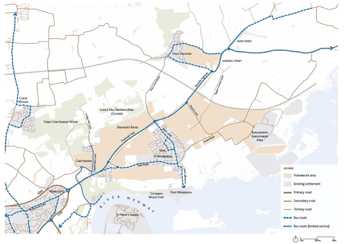
Bus Network
Several bus routes serve Hoo St Werburgh and are operated by Arriva, ASD Coaches and Nu-Venture. Nearby Chattenden, Wainscott and Strood are accessible within a 15-minute journey; Chatham and Grain in 30-45-minutes; and parts of Gillingham including the Medway Maritime Hospital in up to an hour. There is no bus service between Cliffe Woods and Hoo St Werburgh. Services run at poor frequency at certain times of the day. Additionally, buses are often held up in congestion at peak travel times.
Public transport connectivity remains limited and not attractive to users. There is a strong need to modernise and diversify transport modes to give people an attractive and viable alternative to the car. The proposed new station and passenger service will improve connectivity and transform the attractiveness of the Hoo Peninsula.
Any development on the Peninsula needs to be sustainable and future- proofed, where wider transport choice benefits existing and new residents.
2.10 Existing Pedestrian and Cycling Routes
Pedestrian Network
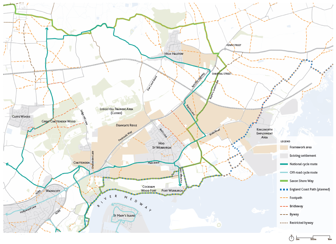
Steep topography and heavy HGV traffic on the A228 are among the major constraints to cycling and walking in Hoo. The A228 is a significant barrier for both pedestrians and cyclists making it difficult to connect the different parts of the village. Footways are provided alongside the highways but do not ensure appropriate safety with either footpaths on only one side of the road or too narrow, at less than the preferred minimum of 2m. In addition, there is a network of off-road footways providing connectivity between the different existing residential areas. Outside of the settlement, extensive Public Rights of Way (PRoW) offer leisure walking routes and connections to neighbouring settlements including Chattenden. Due to the previous military land use the network is fractured in parts and could be improved with additional sections to complete the network around Hoo.
The Saxon Shore Way is a historic coastal walking route running to the south of Hoo St Werburgh and connecting to the village of Upnor. The Saxon Shore Way has an alternative inland route when the high tide prevents walking along the beach. This pedestrian link is well used and allows access to attractive areas of the Peninsula along the river. However, this is a highly sensitive area, of international importance for wildlife. Recreational disturbance can impact on birds, and policies and projects through the Birdwise programme seek to manage access along the estuary.
The England Coast Path is a planned National Trail, which follows the coastline of England. At Hoo, it will connect the existing Saxon Shore Way and Kingsnorth Employment Area with the wider coastline in Kent, Essex, London and beyond.
Cycle Network
Cycle lanes and other cycling facilities in and around Hoo St Werburgh are limited. Main Road and a section of Stoke Road form part of National Cycle Route (NCR) 179, a circular route connecting Chattenden, Hoo St Werburgh, High Halstow, Cooling, Cliffe and Cliffe Woods to NCN 1, a long-distance route running between Dover and the Shetland Islands. It runs largely on-road although there are traffic-free sections between Chattenden and NCN 1 and between Stoke Road and High Halstow. The whole of Hoo is within a 2km radius while Chattenden, Kingsnorth, High Halstow, Lower Upnor and parts of Wainscott are within a 5km radius. Additionally, urban Medway may be within a reasonable cycling distance, but with the steep topography and high volume of traffic along the A228, cycling is not a particularly attractive mode of transport for many residents at present.
Despite constraints to cycling and walking within Hoo St Werburgh and the wider Peninsula, there is a strong potential to enhance the existing network with better lanes and paths and an extension of the current network towards attractive destinations. Promoting greater walking routes and cycling connections around Hoo St Werburgh to access services and provide greater choice of travel options is crucial to ensure a more sustainable way of life on the Peninsula.
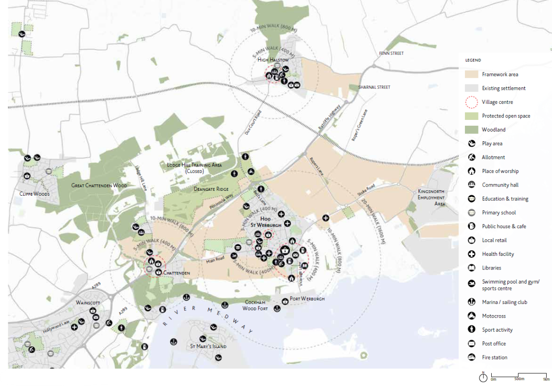
2.11 Existing Commercial and Social Facilities
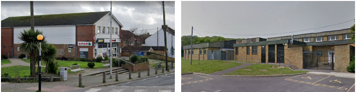
Hoo St Werburgh already performs a service centre role for the wider Peninsula with local facilities and amenities. However, within the course of the last ten years, a number of facilities have been closed within Hoo St Werburgh including a bank, several pubs and leisure facilities. The population has increased significantly with new developments in recent years, but services have decreased in certain areas. Although this may reflect wider trends in retail and services, it is a concern for residents, who experience pressure on some services, and due to the limited offer locally, often choose to travel further afield for shopping, leisure and other services.
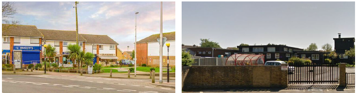
Retail & Community Facilities
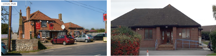
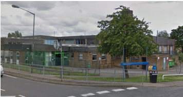
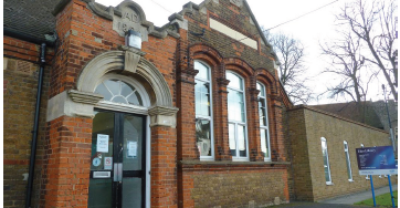
Hoo has a well-established village centre, located around the intersection of Main Road, Stoke Road, Bells Lane and Church Street. It is a focus for the community, and shops are set back behind an open green space, with benches and public noticeboards. Parking is to the rear of the shops, accessed off Stoke Road. Around 30 units are occupied by traditional High Street uses and convenience goods retailers include small Co-op and Spar stores. There is also a newsagents, coffee shop, pharmacy, post office, estate agents and a small number of take-aways. Overall, this provides a good focus for the day to day needs of the local residents and people from nearby villages. There is a also small parade of seven shops on Knights Road in Hoo, including a newsagent, hair salon, grocer/off-licence, take-away and pharmacy, along with a convenience store at the junction of Pottery Road and Main Road. Hoo also provides a range of community facilities and services, including a library, swimming pool, a village hall, various pubs, a fire station and two churches. Although the historic village centre retains its draw for residents, there is limited scope for expansion to bring in new services. It is physically constrained - close to housing and the intersection of roads. The busy junction can create conflict between vehicles and pedestrians. Some of the facilities in Hoo, such as the Village Hall and Hundred of Hoo pool, were built some decades ago, and are in need of modernisation.
There are a few services and facilities in Chattenden, including a community centre, primary school and church. There is limited retail provision. The village reflects its history as an army base. High Halstow has a distinctive and historic village centre. It includes the village pub, church, halls, recreation ground, and the village shop and primary school are close by.
Further retail and commercial infrastructure is provided in Strood and wider Medway. Strood accomodates most of the major supermarkets and is the main food shopping destination for the residents of the Hoo Peninsula.
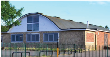
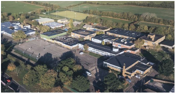
Education
The Hundred of Hoo Academy provides secondary and primary education and other existing education facilities at Hoo St Werburgh include Hoo St Werburgh Primary School and specialist provision at the Marlborough Centre for children with autism. Additional primary schools can be found in the surrounding villages such as Chattenden Primary School and High Halstow Primary School. Young people also travel to schools in wider Medway, particularly for selective grammar schools at secondary level.
Healthcare
Few medical services and a dental practice are located within Hoo St Werburgh: the Elms Medical Centre, St Werburgh Medical Practice and Hoo Dental Care. Health services are currently under significant pressure and there are restrictions in taking on new patients. This is a matter of great concern for residents.
Recreation & Leisure
There is a range of public open spaces in and around Hoo St Werburgh with a few playgrounds, playing fields and parks. Further recreation facilities can be found close by such as Frindsbury Tennis Club and indoor bowls at Deangate Ridge.
An extensive network of Public Rights of Ways provides recreational walking and cycling routes around Hoo, but suffers from fragmentation and does not provide a coherent network of pathways or a connection to main destinations within the area.
The quality and quantity of the existing facilities need to be improved to better serve the growing local population with rising demand for more services and good leisure facilities. Large scale development on the Peninsula would also require a significant increase in the number of facilities in key locations. Increases in residents will provide a strong customer base to stimulate the market to up-lift the quality and quantity of shopping facilities and services across the town and within its adjacent villages. The scale of services needed to cater for Hoo's growing population will mean new facilities and shops across the town. It will be important to manage the development of new centres to ensure that the existing village centre is not undermined. The phasing of key infrastructure, such as schools and healthcare is critical to growth, avoiding unacceptable pressures on existing services and residents. Development planned at High Halstow and Chattenden also needs to respect the role of existing centres and services.
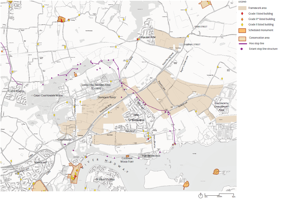
2.12 Heritage
The Hoo Peninsula is a distinctive place. The past can still be seen in today's landscapes. The landscape of the Hoo Peninsula is a product of local people's adaptation and management of the peninsula and its estuaries through fishing and the farming of crops and livestock over thousands of years. The area has particular significance for military and industrial heritage.
There is potential for the historic environment and heritage to contribute positively to the present and future communities of the Hoo Peninsula and the wider Medway area. The area has a wide-ranging and fascinating past that can be used to shape the growth in the area and contribute significantly to an attractive life in the future and the wellbeing of residents and visitors alike. Heritage features such as the coastal forts could play a greater role in Medway's tourism offer.
In the context of potential future change, strengthening the links to the area's past can help to shape distinctiveness in new development and engender a sense of place and local community. These links can be made through enhancement and re-use of heritage assets and their interpretation.
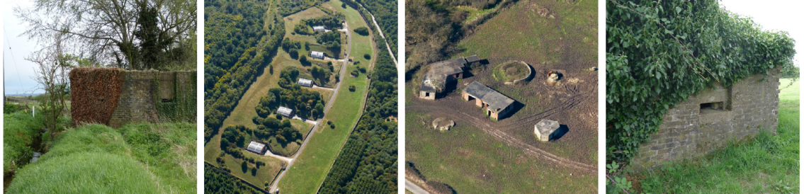
Chattenden and Deangate have particular significance for military heritage. The second World War General Headquarters stop line ran across the peninsula from Hoo St Werburgh to Higham. It is a notable surviving example of anti-invasion defence. A number of pillboxes in this area have been designated listed buildings. The stop line provides an opportunity for green infrastructure, providing residents with attractive paths and increasing awareness of the important role played by the peninsula in the past. There are a number of other features in the wider area which also lend themselves to interpretation and inform the planning of green spaces.
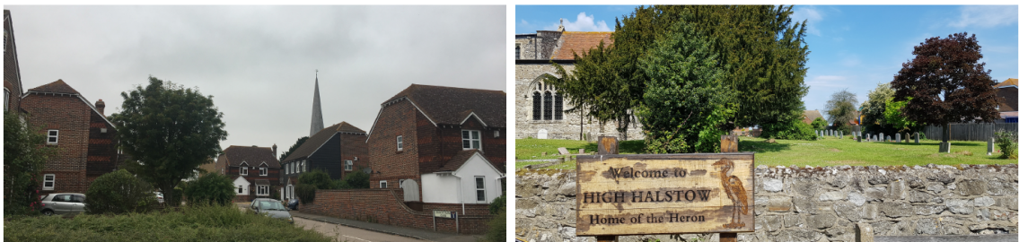
High Halstow has changed significantly during the 20th century, however there remains the medieval St Margaret's Church and dispersed upland farmsteads, which reflect the village's rural character.
There is also potential for archaeological interest, including prehistoric and Romano-British remains in the vicinity of Hoo. The Medway Estuary was, in Roman times, an important regional centre for salt and pottery production, and there are also numerous examples of more recent heritage assets along the coast, notably the Cockham Wood Fort, which is on the Heritage at Risk register.
The 'Whose Hoo' project could help the local communities engage with the wider growth proposals to shape development to by helping them discover and celebrate the heritage and habitats of the Hoo Peninsula. Currently the project has received initial support from the National Lottery Heritage Fund and has an initial integrated programme of heritage schemes and events. Proposed schemes include securing volunteers to study the archaeology and industrial history of the peninsula, improve surroundings and deliver events introducing the area's military history to local people.
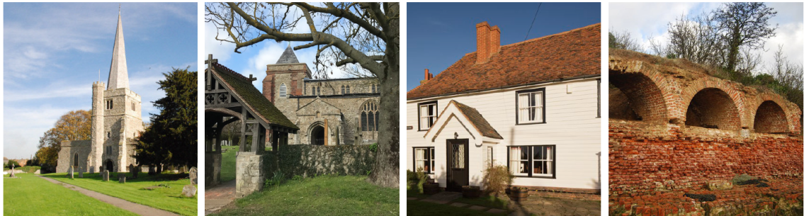
(From left to right) Figure 2.47 St Werburgh Church, Grade I Listed. Figure 2.48 St Margaret Church High Halstow, Grade I Listed. Figure 2.49 Great Dalham farmhouse, High Halstow, Grade II listed. Figure 2.50 Cockham Wood Fort, scheduled monument.
2.13 Historic Development and Heritage
The Hoo Peninsula separates the estuaries of the rivers Thames and Medway, dominated by an extensive area of marshland. The area has been inhabited since the Bronge Age and is rich in archaeology from Roman times to World War II. The name Hoo derives from the old English word for spur of land and features in the Domesday Book as Hoe.
The estimated 2019 population of 29,772 people in Peninsula and Strood Rural wards is spread across various settlements of different scales including Chattenden, High Halstow and Hoo St Werburgh. With over 9,000 residents, Hoo St Werburgh is the largest village in the Peninsula which serves as the main hub, providing key services and facilities for the wider area.
The historic urban growth in all three settlements follow a natural development pattern, starting from a junction of the ancient roads expanding out along the main roads and filling in the land between the roads.
The continuous population growth of villages on the Peninsula shows the merging of settlements such as Hoo St Werburgh and Chattenden where only a narrow gap of fields is left between the two. The growth of High Halstow also appears to be significant throughout the years, from only several houses before the 1940s to hundreds in 2018. There was rapid development on the Peninsula in the post war years coinciding with the opening of the power stations at Grain and Kingsnorth.
Large scale growth on the Hoo Peninsula would bring much change to the area. Change may create some pressure on the character of the existing settlements. New services and facilities would come with housing and Hoo St Werburgh would grow into a small town. There would be new neighbourhoods in the town and High Halstow and Chattenden would be much larger villages. This requires a sensitive and careful urban design approach in order to accommodate growth while maintaining and seeking opportunities to improve the rural character of the area.
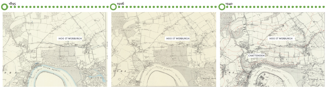
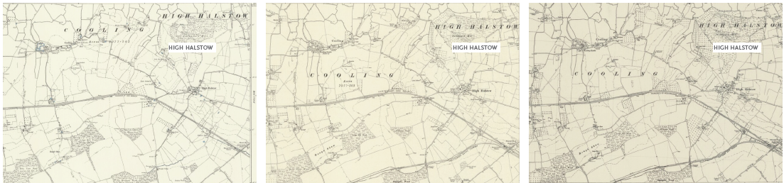
Figure 2.54 Historic transformation of Hoo St Werburgh, Chattenden and High Halstow: 1895-1940
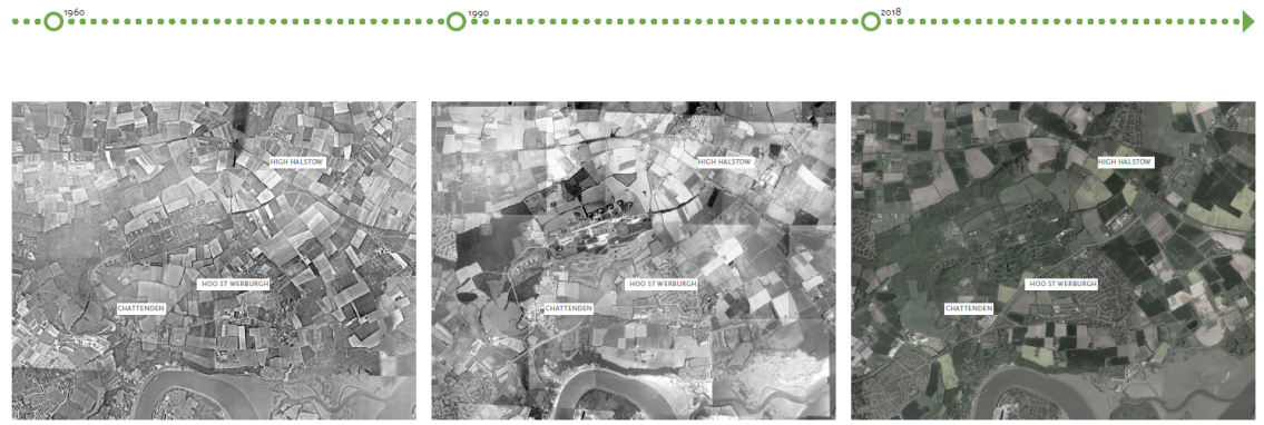
Figure 2.55 Historic transformation of Hoo St Werburgh, Chattenden and High Halstow: 1960-2021
2.14 Local Character
Hoo St Werburgh
Historic Development
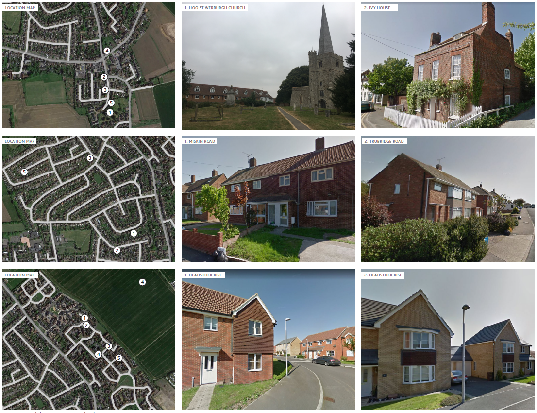
The historic Hoo St Werburgh is located towards the south of the settlement along Church Street and around the church of St. Werburgh. The oldest and most remarkable buildings are the church, the Hoo Library, the Ivy House, and The Chequers Tavern. These buildings present a wide range of architectural detailing and materials.
Typical features include Georgian detailing and mansard/half hipped roofs, and timber cladding. Additional historic buildings, mostly farmhouses, can be found outside of Hoo St Werburgh historic centre, along historic routes throughout the Peninsula.
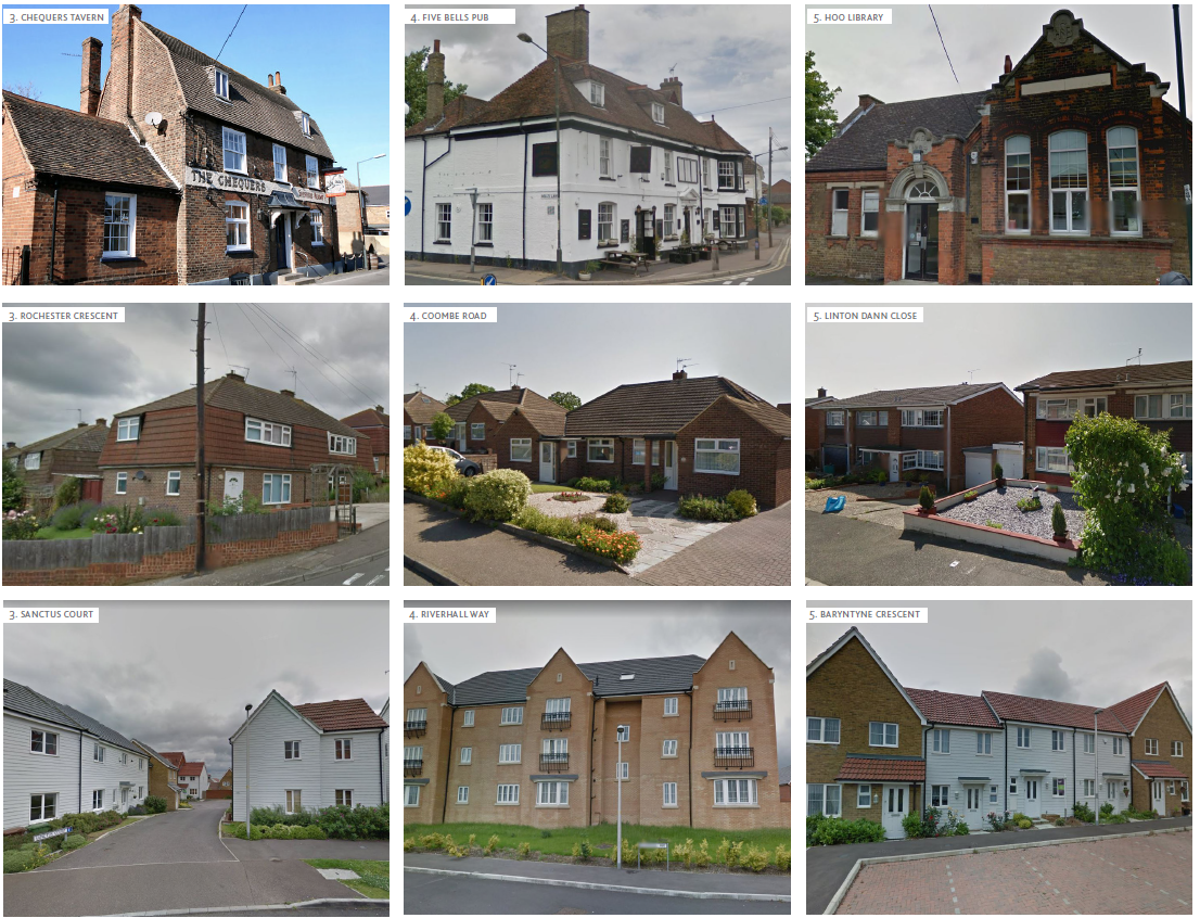
Post War Development
The larger part of the village's urban fabric is shaped with post-war detached and semi-detached council housing laid out along gently curving roads and varying from one to two levels. The majority of the streets run in east-west directions with occasional roads across the contours providing the river bank vistas. Generous front gardens enable transition between levels and sometimes give the streets a green character when they are not converted into parking spaces.
Active frontages are present in Knights Road area with commercial facilities on the ground floor. Most of the buildings from this period are made of red bricks with occasional buildings presenting painted/plaster finishes and some housing from the 1960's-70's built of pre-fabricated concrete panels.
Contemporary Development
Recent developments are mostly concentrated to the east of Bell's Lane. Houses are detached and semi-detached buildings or 2 to 3-storey blocks of flats. Housing is arranged in smaller clusters, the street pattern is curvier and the area has better permeability compared to the post-war development.
Typical materials are red and yellow brick as well as white and brown wooden finishes.
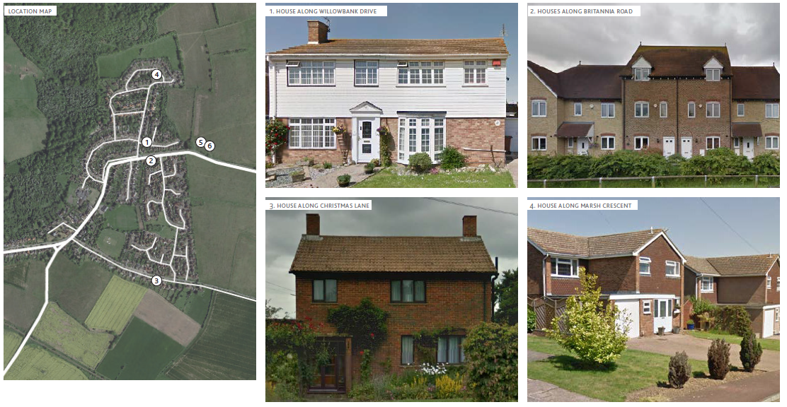
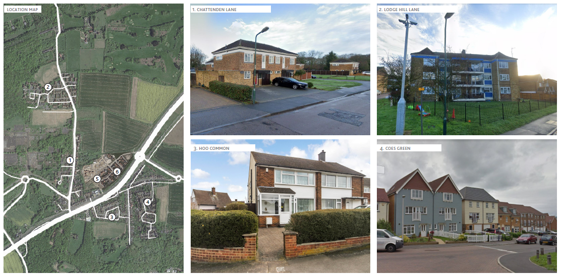
High Halstow Local Character
The village formed at the convergence of Cooling Road, Dux Court Road and Christmas Lane, organised around the church of St Margaret's and a coaching inn. There is no formal village green as a centrepiece, with the main open amenity focus being the churchyard. The large recreation ground is situated behind the Village Hall. Housing expanded organically outward along these existing road, initially northward along The Street and the estate centred on Longfield Avenue.
Further development filled in the area between Christmas Lane and Britannia Road. The three principal roads of The Street, Christmas Lane and Britannia Road define the structure of the village. The main open space amenity area takes the form of the cricket pitch, created between 1940 and 1960. The main streets are significantly linear and straight, producing a formal character and grain. The frontages have strong green boundaries with mature domestic landscaping. Latterly, this has in part been replaced with fencing and car access producing a diverse character. Plot sizes are mixed, but for the most part generous in scale. Buildings are set back creating an open character behind the frontage boundaries
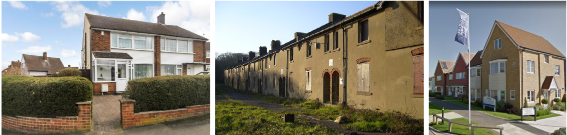
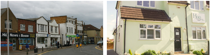
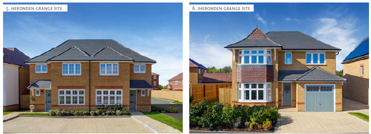
Within the local area can be found a variety of buildings, constructed in different styles and with varying materials and finishes. The adjacent photos provide a selection of the units found in the vicinity, with most buildings constructed within the 20th and early 21st centuries.
Most of these units are predominantly 2 storeys in height, of a simple form and scale. Some houses have rooms in the roof, extending to either 1.5 or 2.5 storeys. Most residences are set back from the road, behind modest gardens.
Most of these buildings are constructed of red or multi-brick with red/brown concrete tiles, there are also some elements of buff brick and slate grey colour roof tiles. Some key units on the street have render, timber or tile hanging.
Chattenden Local Character
Chattenden is a small village located to the west of Hoo and is split by the A228. An important aspect of its character comes from its past military uses and housing for army personnel and families. It is rich in military heritage and its environmental assets. Chattenden and Lodge Hill Military Camps were British Army training camps built as ordnance depots and functioned as such through to the second half of the twentieth century.
Within Chattenden, a large variety of building typologies can be found - from bungalows to flat blocks all constructed in the second half of 20th - early 21st centuries. Building heights vary from 1 to 3 storeys and the predominant material is red brick.
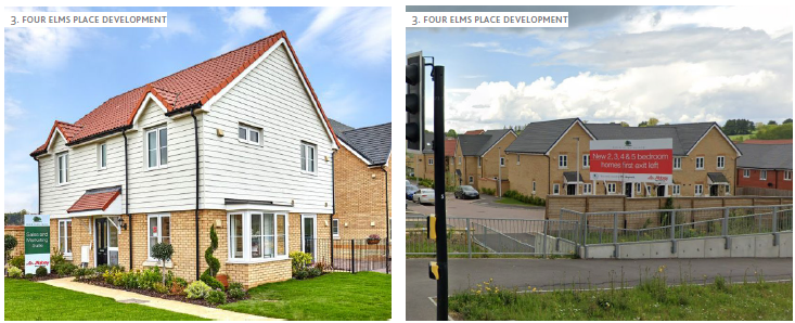
The recently completed Four Elms Place development east of Chattenden Lane and north of the A228 Peninsula Way comprises 2 to 5 bedroom homes - terraced, semi-detached and detached.
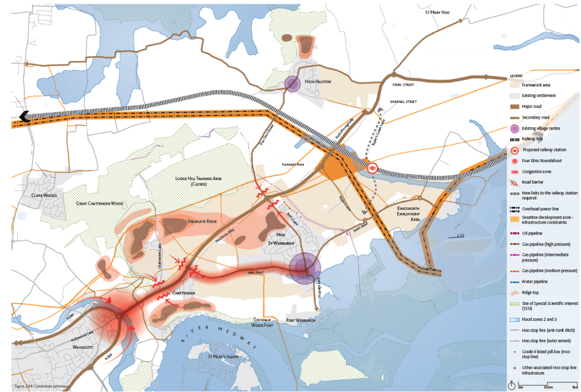
2.15 Constraints Summary
The preceding sections have considered a range of issues and aspects of the Hoo Peninsula's character and offer. This analysis informs the approach to planning new development. There are particular constraints to be addressed. These are summarised below:
- There are significant issues with traffic and air quality in a number of areas, particularly around Four Elms Roundabout which is the primary access point to and from the Peninsula. If unmitigated additional homes will put further pressure on the existing road capacity.
- The existing pedestrian network is fractured in many places both within and between the existing communities.
- Peninsula Way is a significant physical barrier for pedestrian movement with limited crossings. Multiple safe crossing options should be considered.
- Lodge Hill north of Peninsula Way is closed to the public, limiting access to the nearby countryside.
- Cockham Wood SSSI separates the potential for new development from Saxon Shore Way, limiting pedestrian access to the sensitive waterfront.
- The scale of growth will require new services and facilities that can not be accommodated in existing centres. Connections to existing villages are important, to lessen dependency on car trips.
- There are a number of infrastructure and utilities services in the area, including energy and fuel lines, that present constraints to development.
- Extensive scale and character of employment land at Kingsnorth - its interfaces with residential areas should be worked through carefully.
- The proposed rail station is located adjacent to open countryside, which needs to be carefully integrated into the surroundings and new links to this area need to be provided to ensure seamless connectivity to the station for local communities.
2.16 Constraints
Environmental Designations & Heritage
- Parts of the Framework area lie within SSSI integrated risk zones or in close proximity to them, which restrict development.
- Any proposed development should have the highest regard for SSSI, Ramsar and SPA designations, their significance internationally and the biodiversity assemblages that they support.
- The flood zone limits expansion towards the river and an attractive landscape.
- Hoo Peninsula has diverse history and there is significant potential for archaeological and wider heritage interest. Key features such as the Hoo stop line need to be recognised, and steps taken to respond positively in planning new development.
Mobility & Road Network
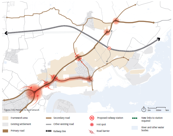
- Limited public transport offer increases reliance on private vehicles.
- Congestion experienced in a number of areas (e.g. Four Elms Roundabout).
- New development is assumed to increase traffic and have impacts on air quality unless measures are put in place.
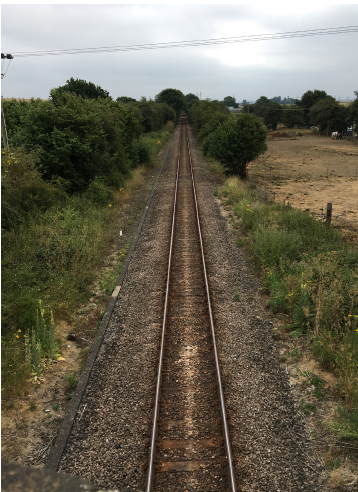
- Existing rail freight line creates a physical barrier.
- The existing pedestrian network shows insufficient provision of footpaths in parts (either from one side of the highway or being less than 2m wide).
- Peninsula Way runs through Chattenden and the wider Framework area, and creates a barrier for pedestrian movement, resulting in road safety issues - safe pedestrian crossings should be considered.
- Lodge Hill site is closed to the public, thus is impermeable and creates a barrier to movement and access to woodlands.
- Cockham Wood SSSI separates the site from Saxon Shore Way, limiting pedestrian access to the waterfront.
Centre Hierarchy and Facilities
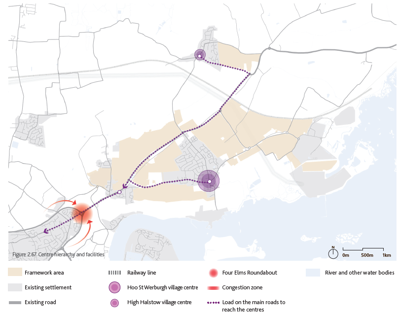
- Limited provision of retail and commercial facilities within Hoo St Werburgh - the physical constraints of the existing Hoo village centre may limit its expansion as a service centre for the wider settlement.
- Lack of facilities and services at Chattenden and strong physical severance of the A228 limiting the access to the historic centre.
- Historic village centre and existing services in High Halstow do not have the capacity to accommodate the scale of new facilities and services to meet the needs from the proposed growth.
- Local population commuting to urban Medwday or further afield such as Bluewater for shopping/ leisure activities causes traffic load on the limited road network, expected to increase with additional population.
- Existing education and health care facilities have stretched capacity. Some of the facilities require refurbishment or expansion, such as the leisure centre with swimming pool.
- Growth will require further parks, gathering spaces and greater provision of services for the local community.
Physical Contraints and Utilities
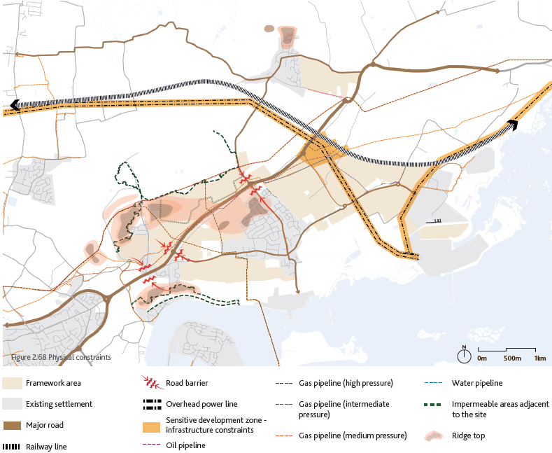
- Peninsula Way creates a barrier for pedestrian movement, resulting in road safety issues.
- Lack of crossing points along Peninsula Way.
- SSSI sites create a strong barrier to movement and permeability within the wider site area and towards the river.
- Power lines and the oil pipeline create a strong constraint for additional development towards the station area.
- Existing built form presents limited opportunities to create new links towards the new neighbourhoods and improve permeability across the overall settlement.
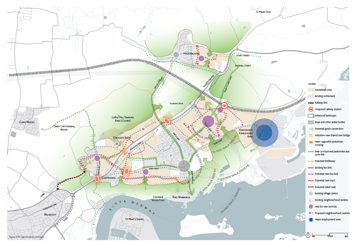
2.17 Opportunities Summary
- New neighbourhoods will bring the critical population mass to support demand for providing new or additional key services and facilities as well as creating employment, particularly around the new passenger rail station. Hoo will be an attractive town providing a range of services for residents on the peninsula.
- Additional new homes along with the new train station will bring opportunities for improved mobility in the area. This includes new or upgraded roads for both vehicles and bicycles, and enhanced bus services across the area. A new relief road can take some burden off Four Elms Roundabout from increased traffic in and out of Hoo Peninsula.
- The general quality of life, particularly the pedestrian experience will be greatly improved through a network of new public spaces, local parks and enhanced accessibility to the existing green spaces and other key destinations. Investments in green infrastructure will strengthen networks for nature.
- Planned growth will provide for sustainable development that addresses climate change in design, travel and green infrastructure.
- A mix of new homes will meet the needs of different sectors of the community and provide choice of well designed places to live.
- Improvements to key junctions and to the wider network infrastructure as a result of the suite of HIF interventions contribute towards increased network capacity and resilience. Enhancements will also ensure that future development requirements for both private, public and active travel are accommodated, whilst seeking to improve sustainability and biodiversity.

2.18 Opportunities
Key Green Infrastructure
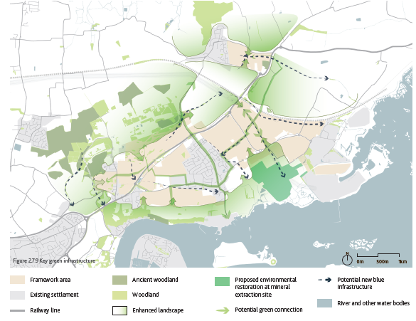
The existing green and blue infrastructure is a key asset of Hoo St Werburgh and the surrounding area, providing an attractive landscape setting to the rural town. There is a strong potential to enhance the existing landscape setting with a well defined and protected landscape and ecological framework including:
- Green links connecting the existing and new neighbourhoods and maximising the development value.
- Ecological wildlife corridors running through and around the overall settlement.
- Country parks providing new large community amenities.
- Providing connections to the past, with integration of heritage features.
- Use of natural capital to increase resilience to climate change and provide carbon storage.
- The Framework should seek to enhance the setting of the land within flood zone 3 to incorporate enhanced ecological habitats, whilst also making use of design principles of sustainable drainage systems (SuDS).
Pedestrian & Cycling Network
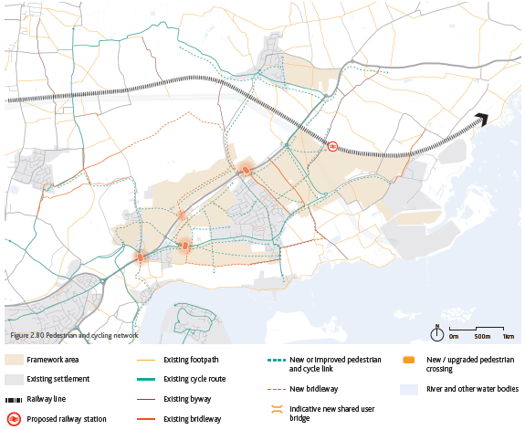
- Potential to deliver a place designed for walking and cycling with attractive, healthy and safe networks.
- Potential to create an extended pedestrian network connecting the existing PRoW with the wider green infrastructure and new neighbourhoods.
- Potential to create an extended cycling network connecting the existing cycling lanes with the wider landscape and destination in and around the Hoo Peninsula.
- Potential to create a new pedestrian crossing over Peninsula Way, improving pedestrian connectivity by linking the northern and southern parts of the rural town.
- Opportunity to improve pedestrian links between the settlement and the river, one of the main attractions around Hoo.
- Potential to create a new direct pedestrian and cycling links between the different neighbourhoods and the new train station.
- Potential to join up dead-end bridleways to expand the equestrian connections network.
Road & Public Transport Network
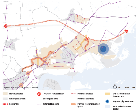
- Opportunities to enhance bus services for existing communities to connect local neighbourhoods and facilities.
- Potential for new bus routes to connect the rural town with retail and employment facilities in the wider Peninsula and Medway area.
- Potential to reinstate passenger rail service and provide for increased rail freight associated with employment land allocations at Kingsnorth.
- Potential to create a new relief road in Chattenden, helping to reduce the traffic and pollution on Peninsula Way and creating business opportunities in Chattenden.
- Greater transport choice will seek to improve air quality issues and address climate change.
Centre Hierarchy and Facilities
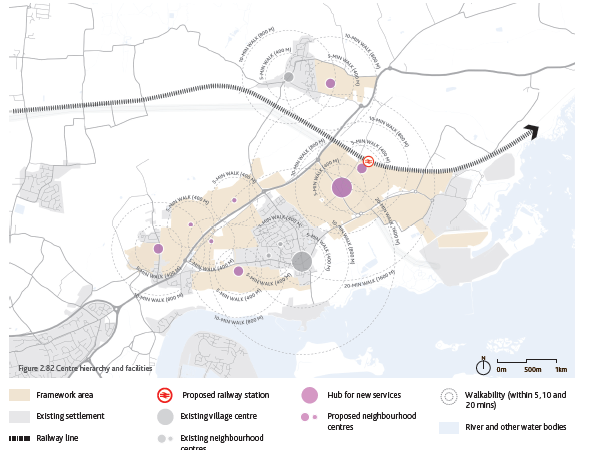
- Potential to strengthen the existing Hoo village centre both with improvement/expansion of existing facilities and making it more pedestrian-friendly.
- Opportunity to reinforce the retail activity and services throughout the rural town by creating new neighbourhood centres complementing the existing village centres.
- Opportunity to provide a wider range of retail, commercial and leisure services for the community, reducing the need for trips to Strood and urban Medway.
- Provision of additional education, healthcare and community facilities to meet the needs of the new population of the Peninsula but also benefiting the existing population.
- Potential to create a new centre where commercial activities and community infrastructure are clustered by the proposed railway station.
- Support Hoo's growth into a vibrant small town, providing accessible local services to meet the needs of all sectors of the community.