Hoo Development Framework
4| The Framework
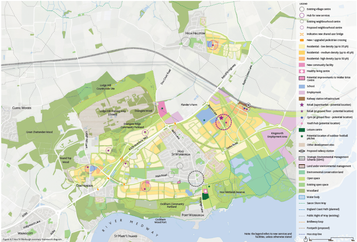
4.1 Framework Plan
The overall Framework plan combines a new vision for Hoo, aspirations and four key principles into an illustrative plan.
Hoo St Werburgh, Chattenden and High Halstow will retain their rural character and unique identity. The villages will be separated by green spaces and countryside. The additional new homes will bring various infrastructure improvements.
This includes a new passenger rail station, road improvements in key junctions and locations, more efficient and frequent bus services, enhancement of both blue and green infrastructure as well as the creation of new country parks and a wetland park.
New homes will also bring an increased number of new services, employment and retail/commercial opportunities set within the distinctive neighbourhood centres and local hubs. Each neighbourhood will have a unique character defined by the surrounding landscape and built form.
4.2 Housing Infrastructure Fund (HIF)
Future Hoo Housing Infrastructure Fund (HIF)
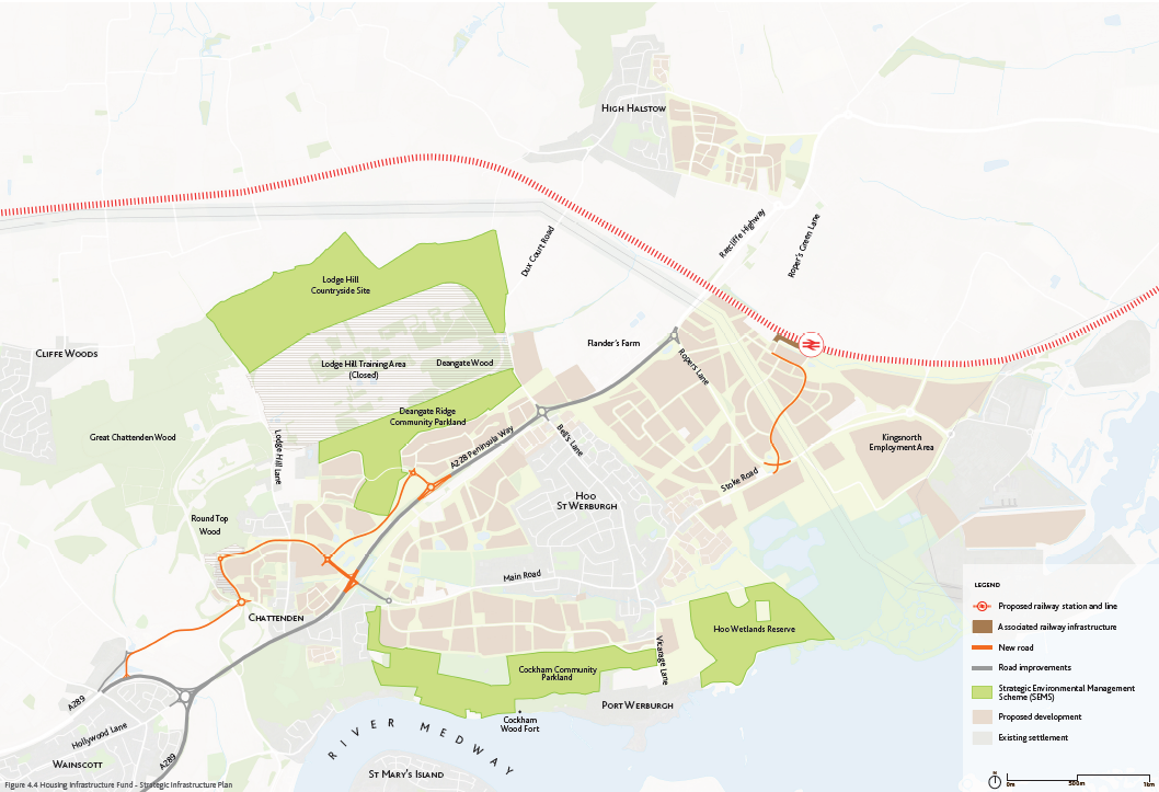
The Government has awarded Medway Council £170m to put in place the necessary environmental and transport infrastructure in advance of major development on Hoo. The Hoo Development Framework incorporates the HIF infrastructure alongside the delivery of other wider services ensuring all are in place to support new housing and the long term, positive planning for growth. The development of Hoo into a new rural town, and associated employment areas, depend heavily on strategic environmental measures plus strengthened connections and significant upgrades to transport. This is what the HIF funding has been secured to achieve . The programme identified necessary highway improvements to the existing A228 and A289, plus a new spur road connecting the Peninsula Way / Main Road to Upchat Roundabout and Woodfield Way, alongside the delivery of a rail passenger service from Hoo on towards London.
The HIF programme is being delivered over the immediate coming years to provide upfront strategic transport and environmental infrastructure. The Hoo Development Framework takes a longer term and wider view of growth on the Hoo Peninsula. This document sets out a vision for development up to 2055.
Delivery of HIF
Strategic Environmental Management Scheme (SEMS) has been developed to deliver large-scale new open spaces managed for both wildlife and for access. This SEMS offer will be in addition to new parks, playgrounds, allotments and sports pitches that will be provided when new residential development comes forward. Listed below are just some of the new open spaces to be provided by SEMS in and around Hoo St Werburgh.
The Cockham Community Parkland (west of Vicarage Lane) sees 41.2 hectares of farmland converted into new habitats including grasslands, new hedges and woodland planting, plus the creation of new path networks and two car parks. Land at Deangate Ridge, north of the Peninsula Way, will become a community parkland and will see the creation of over 6 kilometres of new access routes and the planting of nearly 5 hectares of woodland and scrub. New wetlands are being proposed for land to the east of Vicarage Lane that will support the establishment of habitat for both breeding wading birds plus over-wintering wetland birds.
Plans are also in place to improve public rights of way to ensure users of the green open spaces can walk safely between sites either side of the dual carriage way.
Rangers will be in place to help manage the sites' wildlife and also to ensure people can access and enjoy them without impact on their ecology.
Highway interventions focus on improvements to key roundabouts, including Four Elms, Sans Pareil, and Bells Lane, alongside the creation of new road infrastructure providing access to the new station and to a new connection on Hasted Road. In combination with rail, walking and cycling facilities, the highway improvements look to accommodate the growth in traffic linked to new development in a manner that addresses the Four Elms Hill Air Quality Management Area and other important social and environmental factors.
Rail interventions: The reinstatement of a rail passenger service from Hoo towards London will open up exciting new opportunities for people for work and leisure. Reflecting on rail's attractiveness, a new retail and service hub is proposed near the new rail station, and bus services will be promoted to connect the station to the wider residential and employment community in Hoo.
In summary, the HIF funding allows for masterplanning for wider growth in a coherent, strategic way that sees environment and transport infrastructure provided before houses are built and creates a high quality environment that can be enjoyed by both existing and new residents.