Hoo Development Framework
5| The Neighbourhoods
5.1 Overview
This chapter presents more detail of the Framework design objectives at the local level, with the aim of developing the distinctiveness of each neighbourhood and how they connect with and complement the existing settlements. The Framework examines each neighbourhood through several themes in line with the four key principles outlined in Chapter 3 of this document:
- Overview - outline of the neighbourhood and its general aims and characteristics.
- Open space and pedestrian connectivity - particular green infrastructure interventions and pedestrian routes with the wider area and how they connect with the Strategic Environmental Management Scheme (SEMS) areas.
- Healthy streets and public transport - how each neighbourhood has a clear street hierarchy and where potential bus routes will run. The Housing Infrastructure Fund (HIF) interventions are noted in the relevant neighbourhoods.
- Community facilities and services - level of services in the neighbourhood and where they are located, and how they complement existing centres.
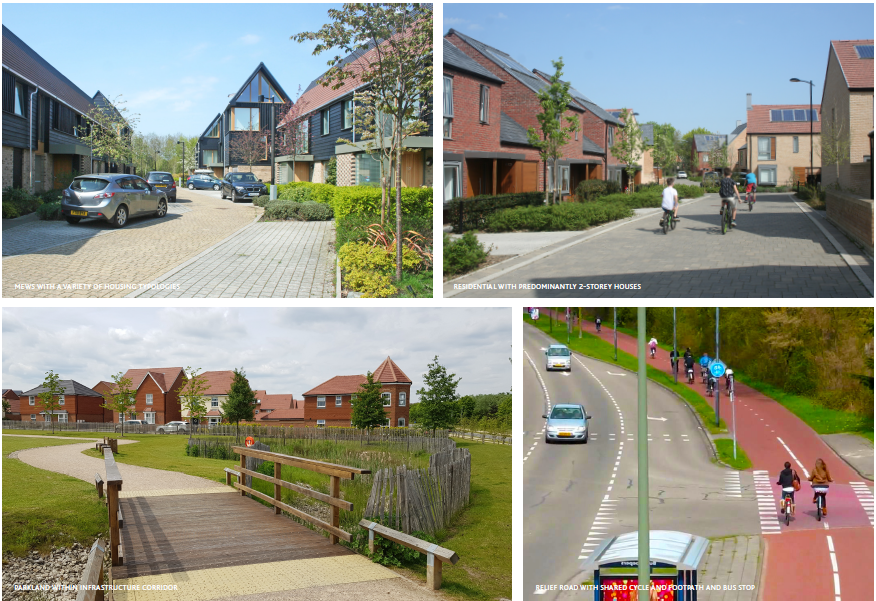
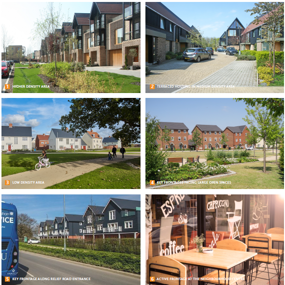
- Housing densities - the scale of development and where low, medium and high development densities are located, with an overview of housing typologies and building heights.
- The descriptions in the following pages do not constitute policy requirements, but set out, in response to the context described in this document, the key design priorities and objectives that the Council is considering as part of the development of the Local Plan. This will continue to evolve as further consultation and engagement and other Local Plan development work is carried out.
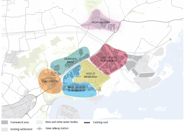
Figure 5.1 Hoo Development Framework proposed neighbourhoods
Chattenden
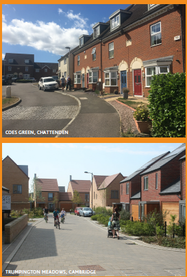
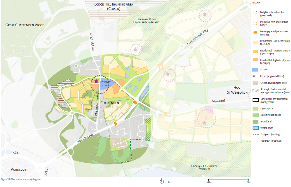
Figure 5.2 Chattenden proposed development overview
The Framework aims to combine the existing fragmented settlement with new development, to form an integrated neighbourhood. A strategic green corridor will separate Chattenden from the new development at West of Hoo St Werburgh. The new development will also respect the adjacent SSSI and existing woodland and new footpaths and cycle routes will connect with the wider Hoo area.
A new neighbourhood centre at Chattenden Lane will include small-scale retail and a relocated and expanded primary school. Housing typologies will be comprised mostly of terraced and semidetached houses to create a sense of enclosure and encourage communal uses.
Deangate Ridge
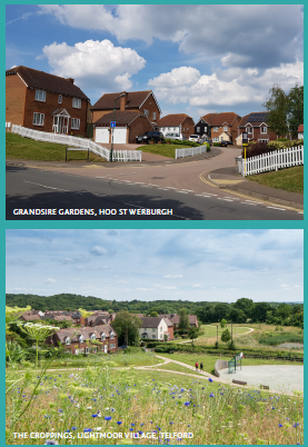
Figure 5.3 Deangate Ridge proposed development overview
The creation of a new community parkland as a landscape buffer to the Chattenden Woods & Lodge Hill SSSI is an integral part of the Strategic Environmental Management Scheme (SEMS). It will be new open space with ecological management in place.
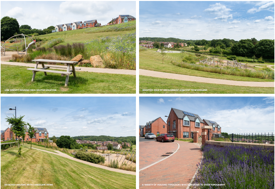
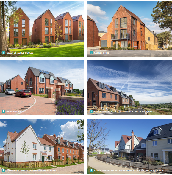
The character of this housing typology focuses on maximising the experience of living in the park setting. The density should be kept low (maximum of 35dph), while buildings are no taller than two to three storeys with a coherent design language to minimise the visual impact of the surrounding landscape. This will help maintaining the rural character of Hoo Peninsula whilst meeting housing needs.
West of Hoo St Werburgh
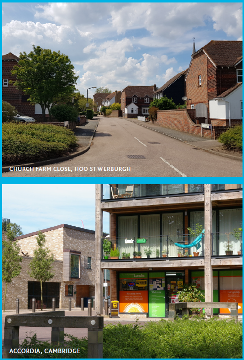
Figure 5.4 West of Hoo St Werburgh proposed development overview
The West of Hoo St Werburgh neighbourhood will be home to a new neighbourhood centre, catering to the western part of Hoo St Werburgh, without competing with the existing centre of Hoo.
The northern part of this neighbourhood will consist of mainly low density housing that is suited to the steep topography, while the southern part will be a mix of low and medium density, with high density concentrated at the new neighbourhood centre. The southern area will connect with the new Cockham Community Parkland, part of the Strategic Environmental Management Scheme (SEMS), and is a new open space which stretches to the River Medway.
East of Hoo St Werburgh
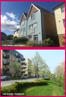
Figure 5.6 High Halstow proposed development overview
This is located adjacent to the proposed passenger railway station which will support new demand for high density homes due to its natural role as a primary transport hub for the Hoo Peninsula. Proposed bus routes will connect with the wider Hoo area, making mixed-mode commuting easier.
This also attracts key commercial, retail and other services that make the area a convenient place to live like that of town centre. Buildings will include a mix of housing typologies which differentiate it from the other neighbourhoods, including flats up to four storeys and terraced houses, to maintain its relatively rural character and will be ideal for a range of people, including single people, couples and young families.
High Halstow
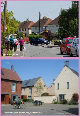
Figure 5.6 High Halstow proposed development overview
The new development at High Halstow serves as an extension to the existing village. New services and facilities in the new neighbourhood centre will complement rather than compete with the existing centre.
New green routes will consist of pedestrian and cycle routes which will connect with Hoo St Werburgh, the marshes to the north and the wider area. Long distance views of the surrounding landscape will be preserved where possible.
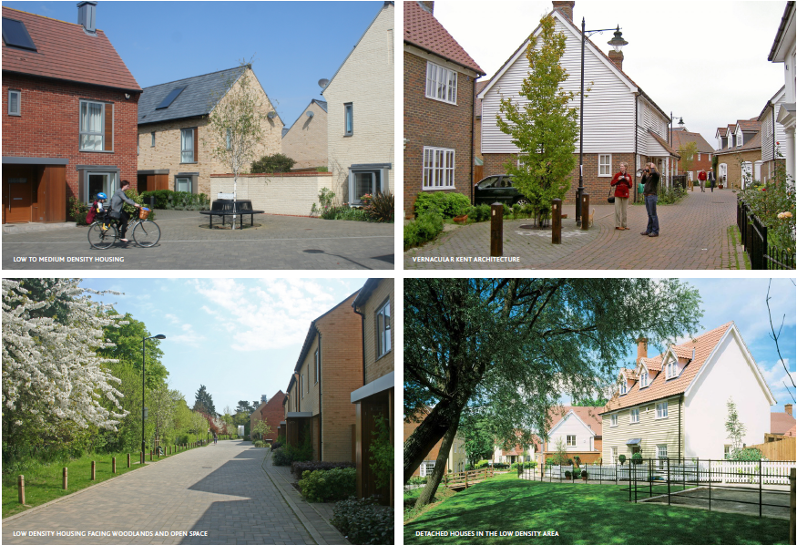
Housing will draw on vernacular architecture in the surrounding area, while self-build and custom housing, together with detached and semi-detached housing will form part of the housing
5.2 Chattenden Neighbourhood Overview
Chattenden Neighbourhood
Chattenden is currently a settlement that is fractured due to its military past and the location of the A228 road, which divides the village in two. The Framework seeks to integrate the existing village with new development and calls for investment in local services to help link old and new areas. New facilities include an expanded and relocated Chattenden Primary School, small-scale retail and community facilities at a new neighbourhood centre along Chattenden Lane. The new development will be sensitive to the natural environment, given its proximity to the Chattenden Woods and Lodge Hill SSSI. Key landscape features such as existing woodland will be enhanced and there will be an emphasise on the protection of local wildlife.
To retain the identity of Chattenden that is distinct from urban Medway and from Hoo St Werburgh, a strategic green corridor between the settlements will be maintained. In addition the strong military connection is an integral part of Chattenden's identity and therefore heritage features, such as the magazine stores, will be maintained.
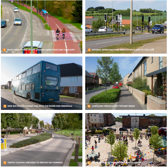
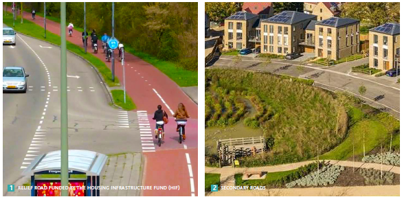
As part of the Housing Infrastructure Fund (HIF) programme, a new relief road is planned, with improved accessibility benefiting the wider Hoo Peninsula. The impact on landscape sensitivity will be taken into consideration, with a potential landscape buffer along the road.
Important links with Cliffe Woods for walking and cycling will be maintained and new pedestrian and cycle routes through Chattenden to Hoo St Werburgh will be created, making access to new services possible including a secondary school in the East of Hoo St Werburgh.
Open Spaces & Pedestrian Connectivity
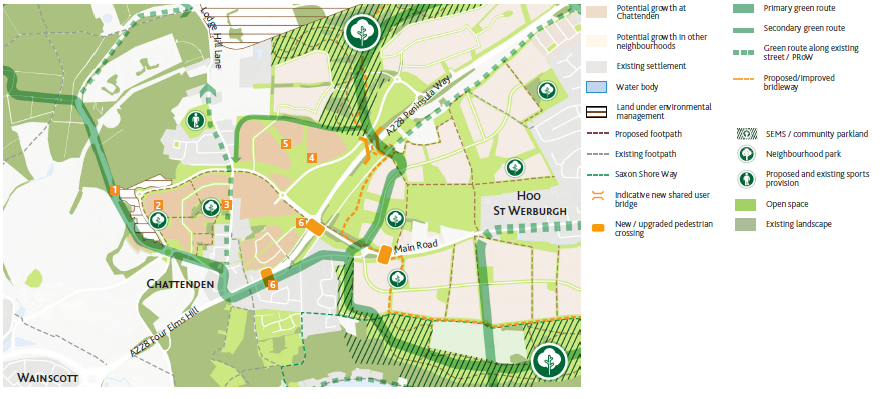
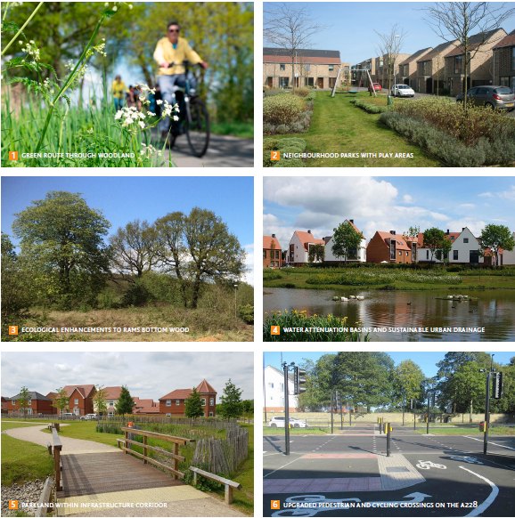
- A new hierarchy of open spaces which are connected by a network of green routes. Rams Bottom Wood at Chattenden Barracks will be preserved and form one of the new open spaces, becoming publically accessible for the first time.
- The existing network of footpaths will be supplemented with new ones. Rams Bottom Wood will be the focal point for new footpaths, while Lochat Road will form a green route connecting with Chattenden Woods and Cliffe.
- Pedestrian crossings along the A228 will be upgraded to improve access between the divided parts of Chattenden.
- Further detailed work is needed to ensure the proposals meet the Local Plan's open space requirements.
Road Infrastructure and Public Transport
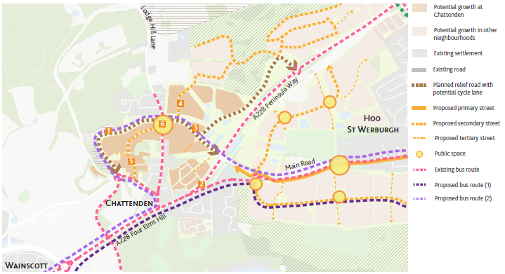
- Chattenden will be supported by the planned relief road as part of the Housing Infrastructure Fund ().
- The secondary roads will form the main roads connecting the development parcels with Chattenden Land and the relief road.
- The existing bus route will be supplemented by new bus routes along the relief road and connect with potential destinations including Hoo St Werburgh, the planned rail station and Kingsnorth employment area.
Community Facilities and Services
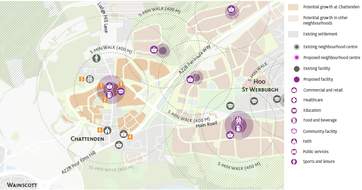
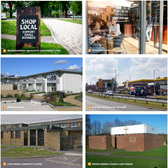
- A new neighbourhood centre located along Chattenden Lane, near the junction with the relief road, will be within a 10-minute walk from most of Chattenden. Services will include small-scale retail, food and beverage and expanded and relocated Chattenden Primary School.
- The new facilities will coexist with existing services. Existing convenience stores along the A228 will continue to serve residents in the south, while Chattenden Community Centre will continue to serve the community.
Built Form
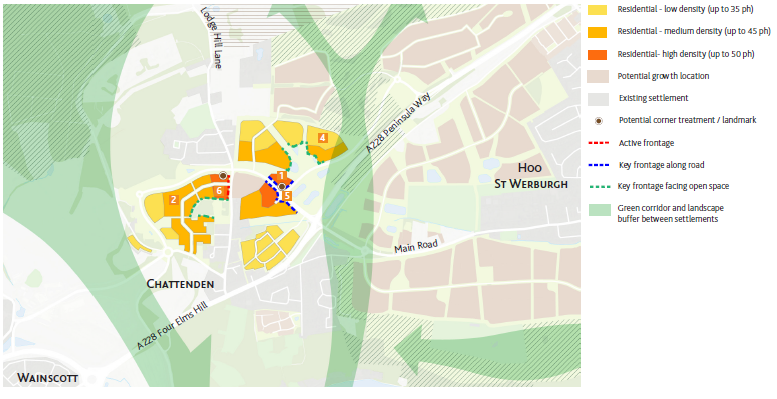
- The proposed relief road will be the principal route to Chattenden, where high density development will be concentrated.
- Development density gradually decreases away from the relief road. At the former Chattenden Barracks site, high and medium density concentrates at the proposed secondary street and decreases further west, to discourage access to the Chattenden Woods and Lodge Hill SSSI, which is ecologically sensitive.
- Potential landmarks or treatments to prominent corners at the proposed neighbourhood centre and at the relief road / A228 roundabout, to mark entry points to Chattenden.
- Chattenden will have key frontages along prominent edges of development:
- An active frontage along Chattenden Lane at the neighbourhood centre
- Key frontage along the relief road from the A228, marking entry to Chattenden
- Key frontage facing existing Rams Bottom Wood at Chattenden Barracks site.
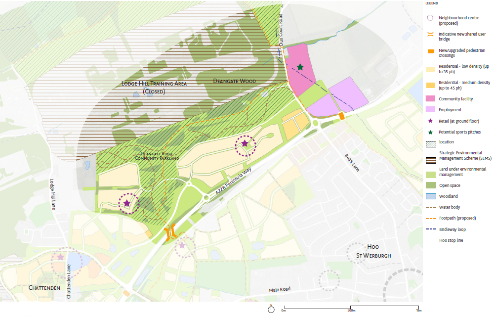
5.3 Deangate Ridge Neighbourhood Overview
Deangate Ridge Neighbourhood
The potential Deangate Ridge neighbourhood is a sensitive environment with specific measures to secure ecology through the Strategic Environmental Management Scheme (SEMS), of which the creation of Deangate Ridge Community Parkland is a major component.
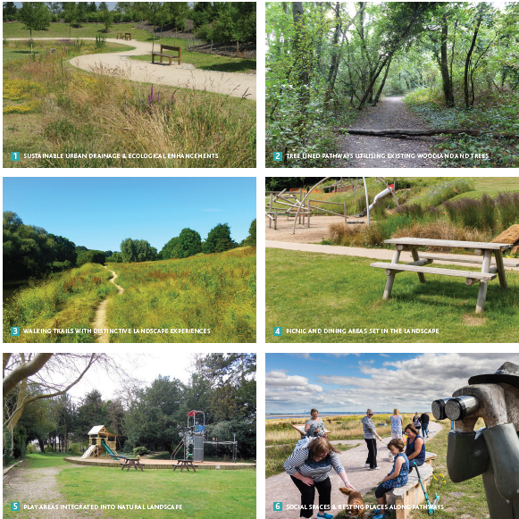
The new community parkland has several aims: acting as a landscape buffer between the proposed development and the Chattenden Woods and Lodge Hill SSSI with ecological measures including grassland management and expansion of woodland; establishing a new open space for use by the community including the re-purposing of an existing building as a new woodland centre and the creation of viewing and picnic areas to capitalise on the long distance views over the former Lodge Hill training camp and SSSI. New footpaths through the community parkland will enhance links to Cliffe Woods, Chattenden and the wider Hoo area.
New housing to be located south of the community parkland and to be low density in character, allowing for mainly detached housing to respond to the topography. The new residential area lies on the northern slope of the ridge, creating the opportunity to maximise landscape views from houses on the edge of the Parkland, so therefore careful attention to orientation to be considered.
The eastern part of the neighbourhood along Dux Court Road allows for other land uses. Deangate Ridge Sports Complex has the potential to be redeveloped for community purposes, while the site at the northeast corner of the Peninsula Way / Dux Court Road roundabout could be considered for employment uses that relate to the local agricultural industry.
Open Spaces & Pedestrian Connectivity
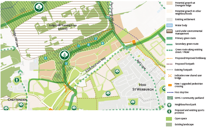
- A new community parkland forms a major component of the new neighbourhood and one of the new parks in the Strategic Environmental Management Scheme (SEMS). Deangate Ridge Community Parkland is a landscape buffer to the adjacent Chattenden Woods & Lodge Hill SSSI, with an ecological management programme including grassland management and woodland expansion. The new community parkland will be an accessible open space, allowing residents to experience outdoor activities such as walking and cycling. There will be viewing and picnic points, which will have long distance views of the Lodge Hill training camp and SSSI to the north.
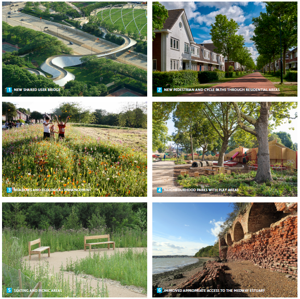
- Deangate Ridge will be connected to the other community parklands via a network of green routes. These green routes will be landscaped pedestrian and cycle routes which connect with the existing network of footpaths in the wider Hoo area. A potential new shared user bridge over the A228 is part of the proposed green route, making north-south travel easier.
- Further detailed work is needed to plan for open space requirements.
Road Infrastructure and Public Transport
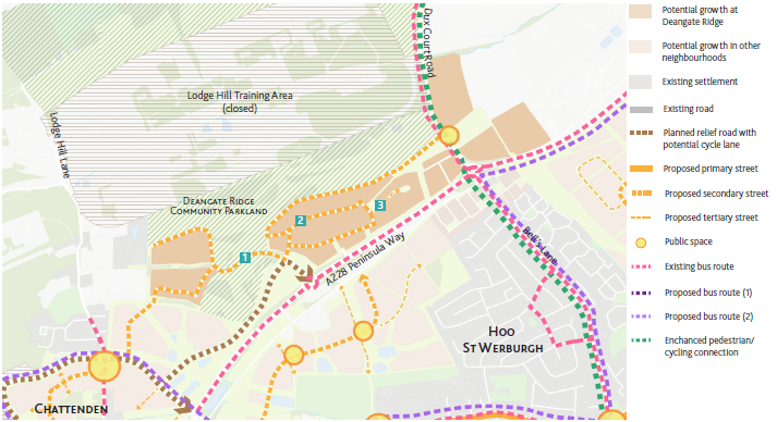
- Deangate Ridge will be supported by the planned relief road as part of the Housing Infrastructure Fund (HIF).
- Secondary and tertiary roads will feed into the relief road, taking pressure off the existing A228 Peninsula Way.
- A new public space will be created at the eastern entrance at Dux Court Road, marking a gateway to the neighbourhood.
- Access to buses will require a walk to Ratcliffe Highway to the south of the A228, or to Chattenden or Dux Court Road. Further studies will be required into future bus provision at Hoo.
Community Facilities and Services
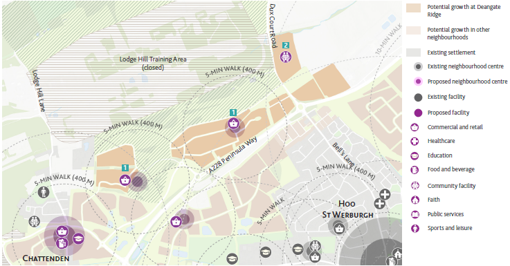
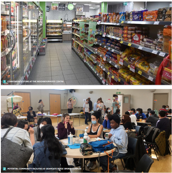
- Deangate Ridge will be a low density neighbourhood with 2 small-scale neighbourhood centres. Each centre will have at least one convenience store to cater to the needs of local residents.
- For more substantial shopping needs, residents can travel to Chattenden or Hoo St Werburgh village centre, which are within easy reach.
- Deangate Ridge Sports Complex will potentially be redeveloped as a community facility, which requires further detailed planning.
Built Form
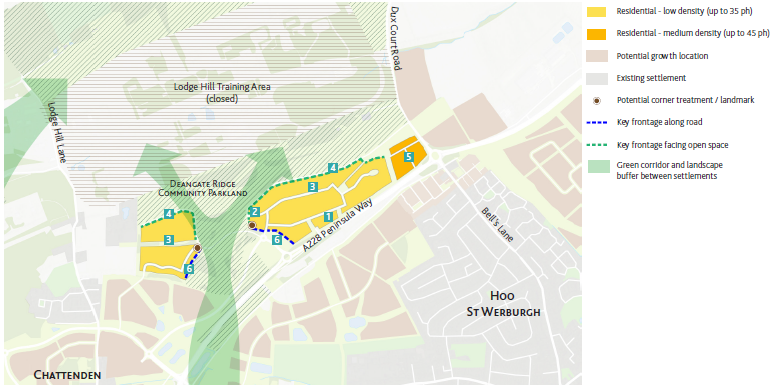
- The residential area lies on the northern slope of the ridge, affording long distance views across Lodge Hill training camp and Chattenden Woods and Lodge Hill SSSI to the north. Low density housing is suited to the steep topography and maximising these views will be a priority. Detached houses will form the majority of the housing mix, with a maximum of 2 to 3 storeys.
- The north-west corner of the Peninsula Way / Dux Court Road / Bell's Lane roundabout will have medium density housing, reflecting its more accessible location of the roundabout.
- Key frontages facing the new community parkland and the relief road, with opportunities for treatment at prominent and highly visible corners.
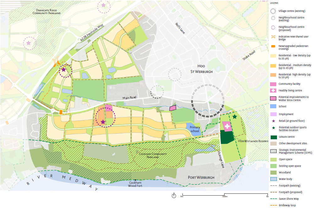
5.4 West of Hoo St Werburgh Neighbourhood Overview
West of Hoo St Werburgh Neighbourhood
The West of Hoo St Werburgh neighbourhood lies at a sensitive location between Chattenden and Hoo St Werburgh and therefore the relationship and connections to existing villages needs to be established.
A green corridor between the existing village of Chattenden (at Coes Green and Toad Hall Crescent) and the West of Hoo St Werburgh neighbourhood will be maintained to prevent coalescence between Chattenden and Hoo St Werburgh. Introduction of a new shared user bridge across the A228 Peninsula Way could encourage new walking and cycling connections across the green corridor between Hoo and Chattenden.
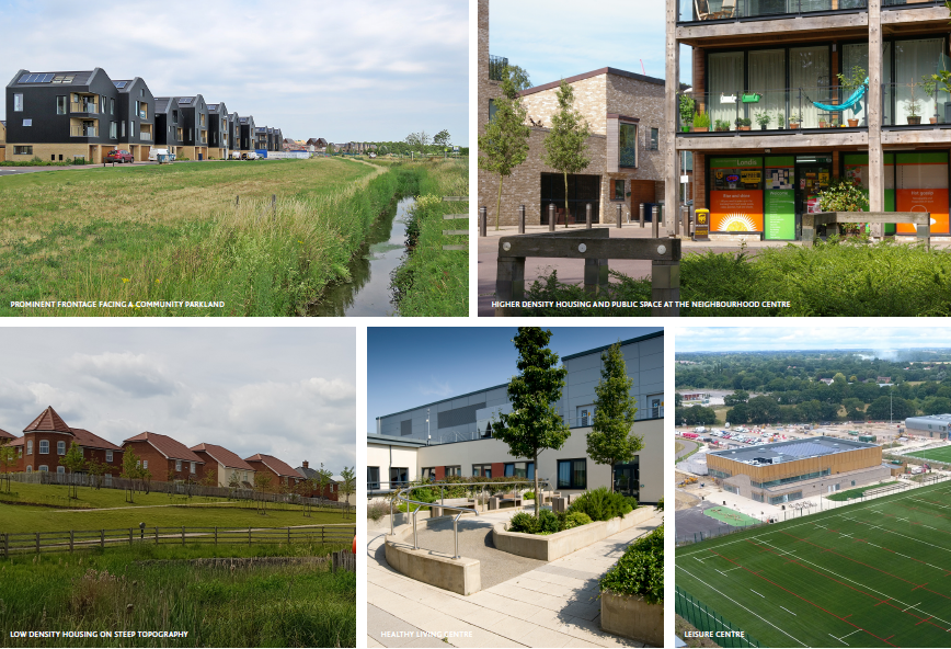
The area to the north of Main Road will be mainly low density in character, responding to the steep topography. The area to the south of Main Road will allow for medium density and a new neighbourhood centre, with small-scale retail and community services. This area will be adjacent to the planned Cockham Community Parkland, a new open space as part of the Strategic Environmental Management Scheme (SEMS) and improve access to the Medway estuary.
Other new facilities are planned at this neighbourhood. A new primary school is planned at the eastern end, while at Vicarage Lane a new healthy living centre and a leisure centre with outdoor pitches are proposed, which are in close proximity to the existing village centre and benefit local residents. Traffic measures will be undertaken to ensure these new facilities are accessible.
New bus links are proposed to ensure that the new development areas connects to Hoo St Werburgh and reduces car dependency in the Hoo Peninsula.
Open Spaces & Pedestrian Connectivity
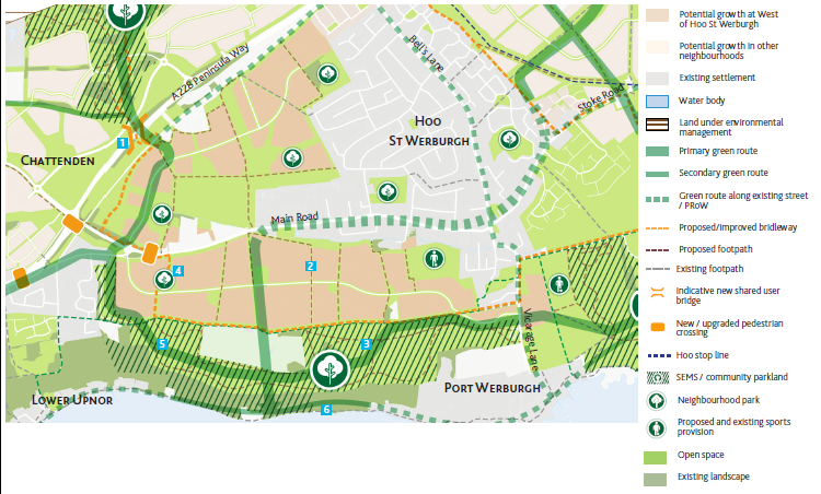
- As part of the Strategic Environmental Management Scheme (SEMS), a new Cockham Community Parkland will be created, opening up appropriate access towards the Medway estuary. A green route loop will connect with the other community parklands at Deangate Ridge (via a potential new shared user bridge) and Hoo Wetlands Reserve.
- In addition to the community parklands, a hierarchy of new neighbourhood parks will be created, which will be evenly distributed to allow even access to open space.
- The existing Saxon Shore Way and planned England Coast path will be supplemented with a network of new pedestrian and cycle routes, which cross the new development to Main Road.
- Further detailed work is needed to plan for open space requirements.
Road Infrastructure and Public Transport
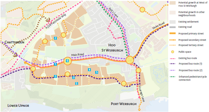
- Main Road will become West of Hoo St Werburgh's primary street, while a new secondary street will form the core of the neighbourhood's road network. Tertiary streets, including the road serving the Wilsonian Sailing Club and Hoo Lodge, will feed into the secondary street.
- New public spaces will be created at prominent junctions, encouraging residents to stop and relax, as part of the healthy streets concept. The most prominent of all will be at the new neighbourhood centre, allowing it to become a social hub.
- The existing bus routes will be supplemented with new routes, connecting with the centre of Hoo, the proposed rail station and High Halstow.

Community Facilities and Services
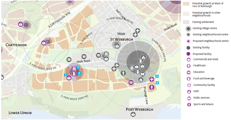
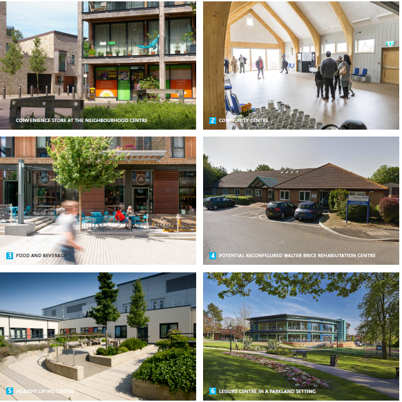
- West of Hoo St Werburgh will have a new neighbourhood centre to the south of Main Road, which will be within a 10-minute reach of most of the neighbourhood. The new centre seeks to complement the existing Hoo St Werburgh village centre, and will feature small-scale retail, food and beverage and community facilities.
- North of Main Road will have a new neighbourhood centre, limited to at least one convenient store to cater to local needs. This will be located in proximity to the potential shared user bridge over the A228.
- A new 2-form entry primary school will be located to the east, serving the growing population.
- Vicarage Lane will be the site of a new Healthy Living Centre and leisure centre with outdoor football pitches. This location will respect the sanctity of Hoo burial ground and also be located away from flood risk zones. The location is ideal for existing Hoo residents, although further detailed planning will be required to address the traffic along Vicarage Road.
- Potential redevelopment of the Walter Brice Centre, subject to further planning.
Built Form
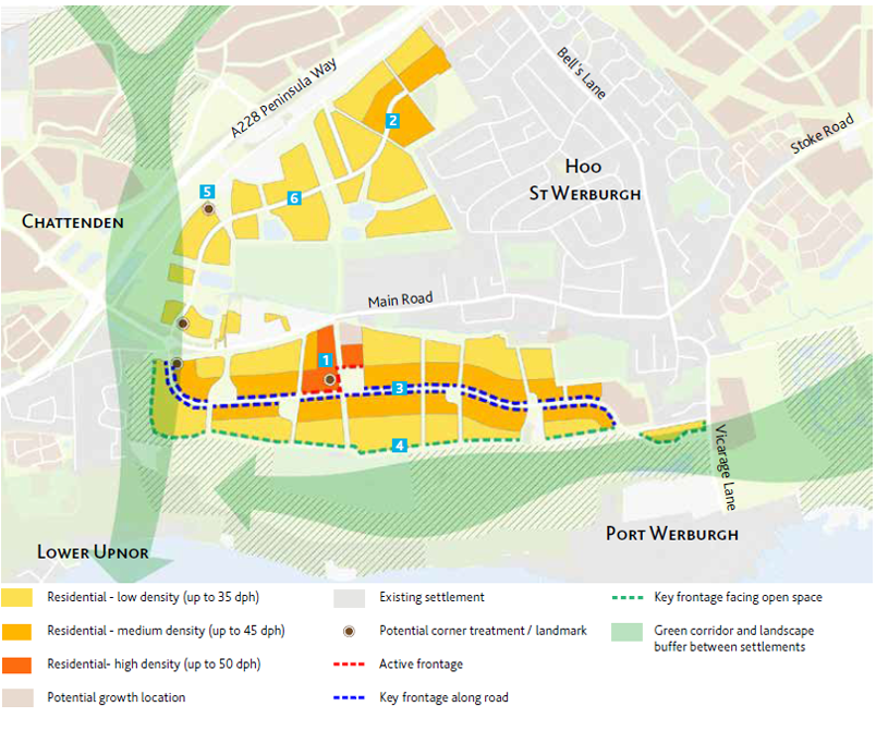
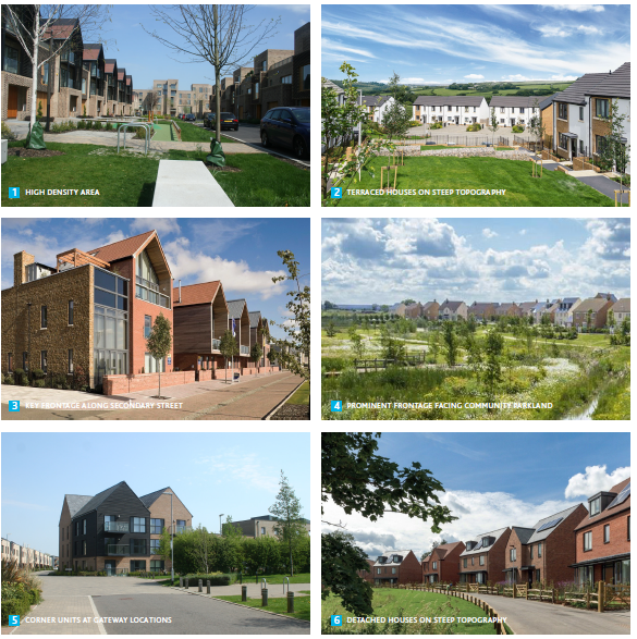
- West of Hoo St Werburgh represents the western limit of Hoo St Werburgh, with a strategic green corridor acting as a landscape buffer separating it from Chattenden.
- North of Main Road will consist largely of low density housing, suited to the steep topography of the south facing slope of the ridge.
- The south of Main Road will consist of a mix of low to medium density, with high density housing reserved for the neighbourhood centre.
- A prominent southern frontage will strengthen the neighbourhood's relationship with the planned Cockham Community Parkland.
- The secondary street through the south of Main Road will feature a prominent frontage aiding wayfinding and street hierarchy legibility. Houses facing the primary street will consist of sections of continuous frontage and small front gardens and generous landscaped verges.
- Prominent gateway points will feature corner treatments that are appropriate to the scale of development.
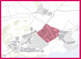
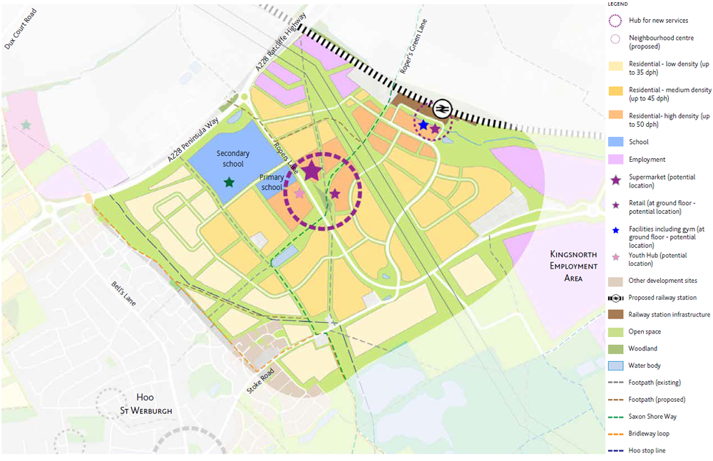
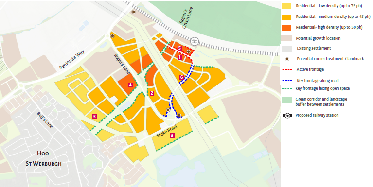
5.5 East of Hoo St Werburgh Neighbourhood Overview
East of Hoo St Werburgh Neighbourhood
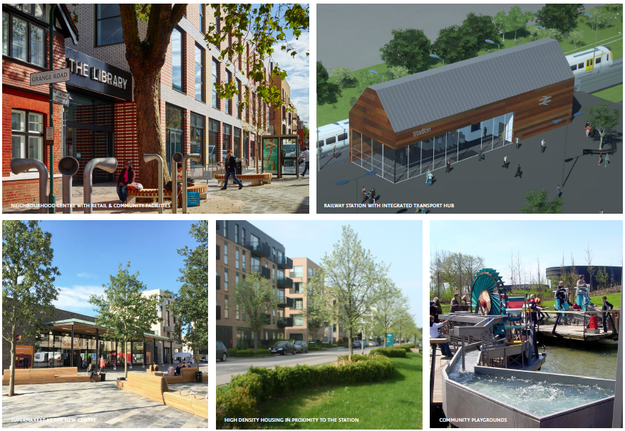
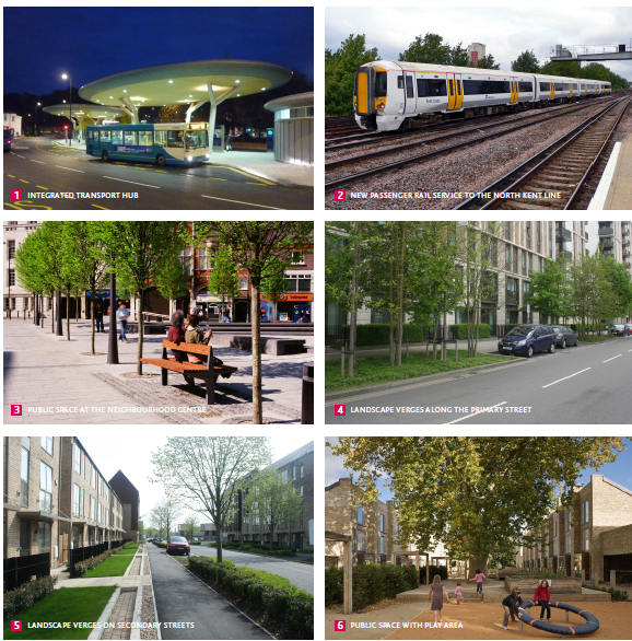
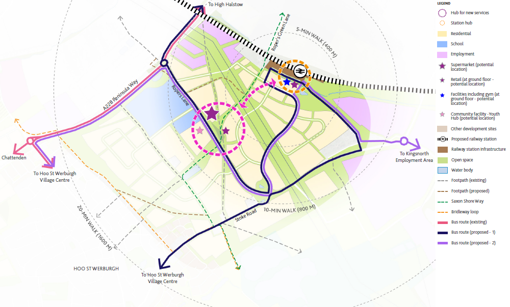
The opening of a new rail station with passenger services connecting to the North Kent Line offers exciting opportunities for the area. The station has the potential to become a major transport hub with improved bus connections serving the wider Hoo Peninsula.
There is an opportunity for a new neighbourhood centre based around the station, bringing together a mix of activities, including homes, services and employment.
The commercial and retail offer will be larger in scale at East of Hoo St Werburgh than at the other proposed neighbourhood centres, reflecting the importance of the rail station to the rural town.
Green infrastructure at East of Hoo St Werburgh includes new green routes for pedestrian and cyclists, including an enhanced Roper's Green Lane, which connect with new open spaces and the wider area. Part of the former Hoo stop line will form one of these new open spaces, complete with wayfinding and interpretive signage, keeping the new development connected to its military past.
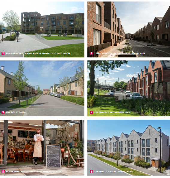
The new neighbourhood will have the highest density particularly around the station at the neighbourhood centre, which will predominately consist of terraced houses and flats. Further away from the neighbourhood centre, housing density will gradually decrease, and in these areas a wider mix of housing, including detached and semi-detached houses, which will complement the character of the existing Hoo St Werburgh. The range of housing types make it an ideal place for young professionals, from singles to young families.
This is a key area for the future success of the rural town, needing a sensitive and creative approach to development. Its location sits close to the expanded employment land, the countryside between Hoo and High Halstow, and the wider rural town.
Open Spaces & Pedestrian Connectivity
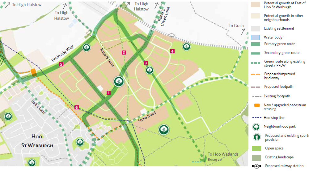
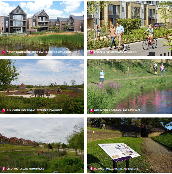
- A network of green routes for pedestrians, cyclists and horse riders, to connect with existing footpaths and bridleways at East of Hoo St Werburgh and the wider area. Roper's Green Lane will form part of a continuous primary green route from High Halstow through to Hoo St Werburgh via Stoke Road. The area under the overhead power lines will also form a green route, connecting with the south.
- A hierarchy of neighbourhood parks throughout the East of Hoo St Werburgh, with larger ones at the widened section of the Roper's Green Lane green route and also by the station with the attenuation basin form an attractive landscape feature.
- The Hoo stop line will form a green open space, with potential for a heritage trail with interpretive signage, connecting Hoo with its military past.
- Further detailed work is needed to plan for open space requirements.
Healthy Streets & Public Transport
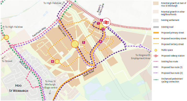
- New primary street, linking the Roper's Lane / Stoke Road roundabout to the station, forms part of the Housing Infrastructure Fund improvements plan. The primary street will have 5-metre verges on both sides, forming a pleasant environment for pedestrians.
- Secondary streets and tertiary streets form a clear and legible hierarchy at East of Hoo St Werburgh.
- A hierarchy of new public spaces at key intersections, encouraging pedestrian activity and movement. A public square at the station will be the most prominent part of the public realm network, acting as a gateway to the whole rural town and the Hoo Peninsula generally.
- New transport hub, incorporating the planned rail station and new bus stops, encouraging mixed-mode commuting.
- New bus routes which complement the existing routes, which connect the station with the wider peninsula.
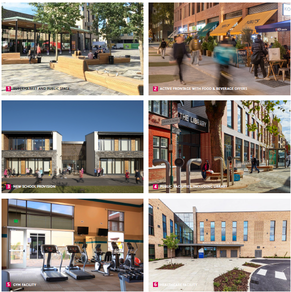
Community Facilities
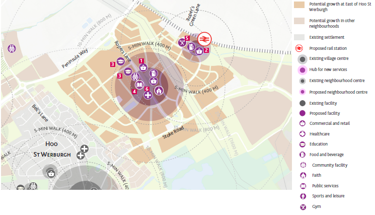
- A hub for new services with a variety of facilities and a supermarket to be located in the heart of East of Hoo St Werburgh, serving the growing population of this neighbourhood and wider Hoo Peninsula providing additional services that will complement and not compete with the existing village centre at Hoo St Werburgh. This hub is to be served by public transport and located on pedestrian links to the wider area.
- Potential for an additional hub by the railway station with some commercial provision, where connecting bus routes serve the wider area.
- A new 8-form entry secondary school and a 2-form entry primary school located in close proximity to each other, at the northern end of Roper's Lane. The secondary school's northern location is intended to serve residents of High Halstow, with potential for a bus service.
Built Form
- Highest density around the station at the neighbourhood centre, which will predominately consist of terraced houses and flats.
- Further away from the neighbourhood centre, the East of Hoo St Werburgh will have medium density, ideal for complementing the new primary and secondary schools. Housing mix to include detached, semi-detached and terraced housing.
- Low density development adjacent to the existing Hoo St Werburgh settlement and south of Stoke Road, where the new development faces the proposed open space at the Tarmac site.
- Maximum 2 to 3 storeys in building height, with the high density area to be predominately 3 storeys in height
- Key frontages facing prominent open spaces, including the primary green route along Roper's Green Lane and the proposed open space at the Tarmac site.
- Active frontages facing the proposed rail station and along the planned primary street at the neighbourhood centre.
- Potential landmark buildings at key gateway locations, such as the railway station and at neighbourhood access points.
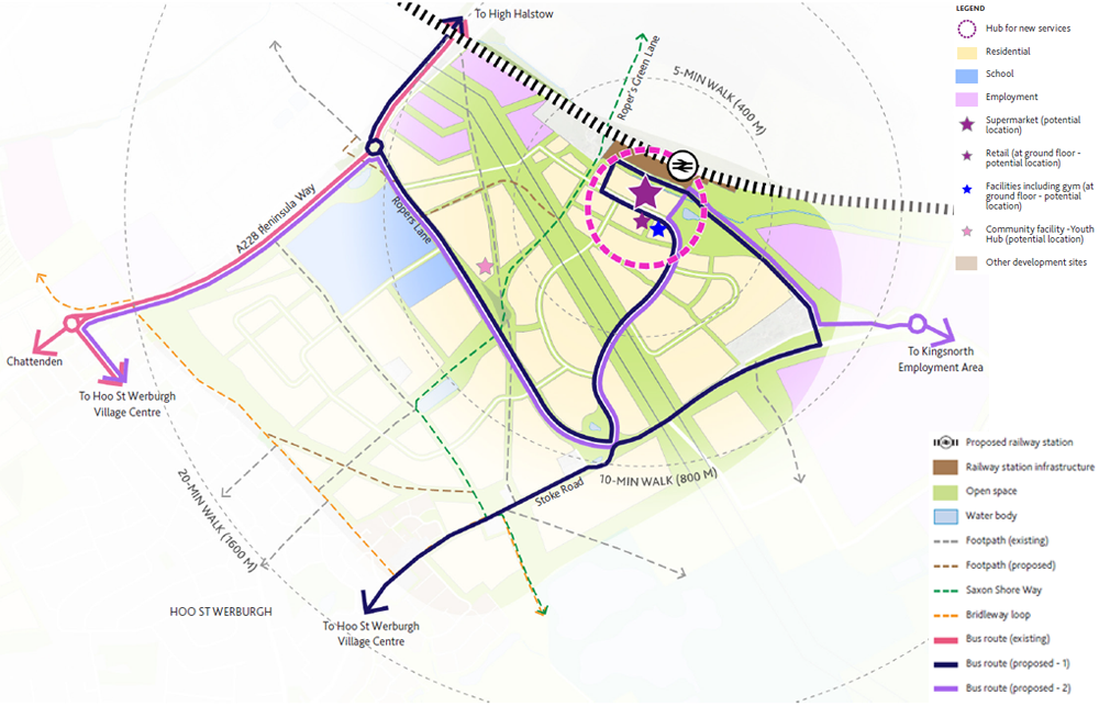
New Centre Location - Option 1
The Framework considers three scenarios for the supermarket location in the vicinity of the proposed railway station, based on independent advice. With the proposed new pedestrian, cycle, bus and vehicular connections to this area, this emerging centre will serve the local community as well as the wider Hoo Peninsula. The exact location of the supermarket and the type of the facilities in the centre is subject to further discussion and consultation.
Key points for Option 1 (see Figure 5.47) include:
- An approach for the neighbourhood, with a linear centre starting from Ropers Lane potentially leading up to the rail station.
- The proposed supermarket is to be located to the east of Ropers lane performing as a key anchor for the new centre. This location assists in linked trips facilitated by the shared supermarket and centre car parking.
- The potential supermarket is to have an approximate site area of 2 hectares, with a gross unit size of between 2,000 and 2,500 square metres. A 100 to 150-space surface car parking is to be provided within the site.
- The new centre will provide a complementary high street offer that would be in harmony with the existing Hoo St Werburgh village centre thereby avoiding harm.
- The rail station would be part of a multi-modal interchange and can be accompanied by limited complementary uses for transport users. The offer would be different to that located in the proposed new centre to avoid negative impacts on the centre. The potential location of the centre is an appropriate distance away from the existing Hoo St Werburgh centre without having an adverse impact on its health.
- The main disadvantage of this option is that the aspired hub is not achieved.
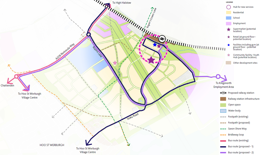
New Centre Location - Option 2
Key points for Option 2 (see Figure 5.48) include:
- An approach for the neighbourhood, with the centre focussed on the rail station, which is a hub where retail and other facilities are concentrated.
- Potential for a supermarket directly opposite the proposed railway station, with a site area of approximately 2 hectares, with a gross unit size of between 2,000 and 2,500 square metres. A 100 to 150-space surface car parking is to be provided within the site, which is to be shared with the rest of the centre.
- Potential for small-scale retail, service and food and beverage units, up to 20 in total in and approximately 100 square metres each, to be located in close proximity to the station, with opportunities to amalgamate two or three units into one. The total units could be delivered in phases over the course of the development of the new community, up to 10 units at a time.
- The potential location of the centre is an appropriate distance away from the existing Hoo St Werburgh centre without having an adverse impact on its health.
- The key advantage of this option is the creation of a hub, where the station, retail and other facilities are in one location, within walking distance of each other. In addition, siting the supermarket directly opposite the station creates a sense of arrival for railway passengers entering and exiting the station, and aids legibility of the centre.
New Centre Location - Option 3
Key points for Option 3 (see Figure 5.49) include:
- An approach for the neighbourhood, with the centre focussed on the rail station and a supermarket located further south.
- The proposed supermarket is to be located to the east of Ropers lane performing as a key anchor for the new centre. This location assists in linked trips facilitated by the shared supermarket and centre car parking.
- The potential supermarket is to have an approximate site area of 2 hectares, with a gross unit size of between 2,000 and 2,500 square metres. A 100 to 150-space surface car parking is to be provided within the site, which is to be shared with the rest of the centre.
- Potential for small-scale retail, service and food and beverage units, up to 20 in total in and approximately 100 square metres each, to be located directly opposite the station, with opportunities to amalgamate two or three units into one. The total units could be delivered in phases over the course of the development of the new community, up to 10 units at a time.
- The potential location of the centre is an appropriate distance away from the existing Hoo St Werburgh centre without having an adverse impact on its health.
- The potential retail units between the rail station and the anchor supermarket encourages footfall between the two locations and ensures that the active uses between are healthy and vibrant. However, the supermarket is not in the immediate vicinity of the station in this scenario, which weakens the compact nature of the hub.
- Growth of the centre could occur further south of the supermarket.
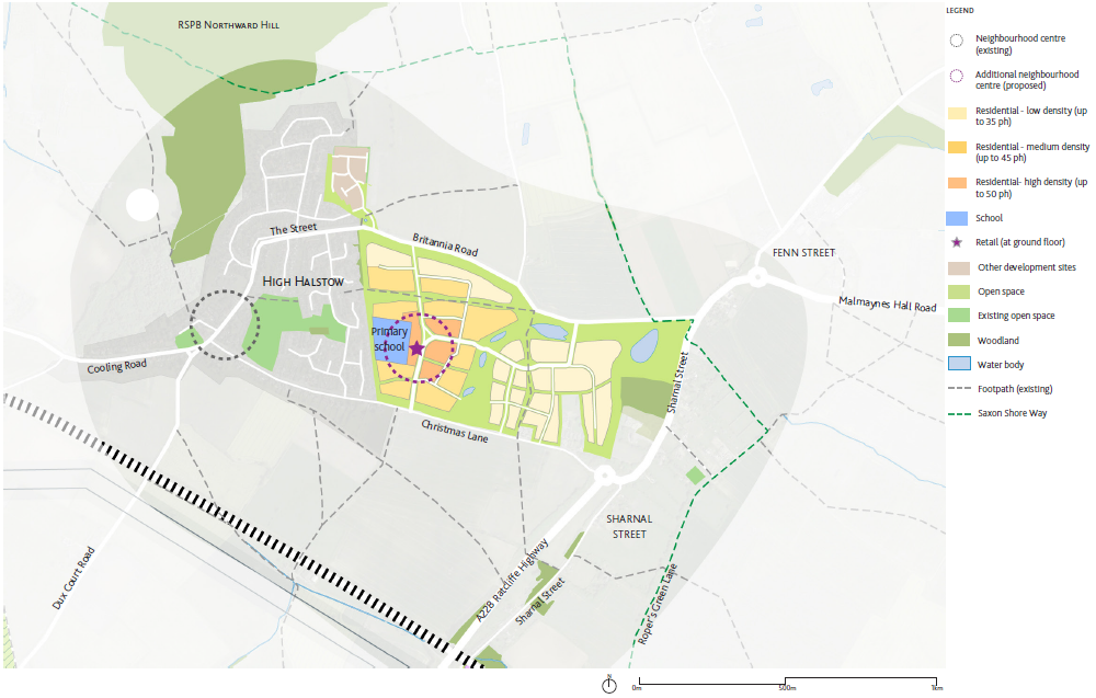
5.6 High Halstow Neighbourhood Overview
High Halstow Neighbourhood
The existing village of High Halstow is surrounded by a tranquil landscape setting with fine views. The scale of proposed growth will significantly extend High Halstow, which therefore needs sensitivity and investment in quality design. The proposed extension seeks to help High Halstow retain a distinct identity and separation from Hoo. The countryside between High Halstow and the new station at Hoo will remain open. Connections to the natural environment and sites to the north, as well as long distance views will be retained. The marshland to the north and shoreline along the river Thames will be left intact, with green routes strenghtening these connections.

One of the key benefits for existing residents will be the proximity to the proposed railway station, which forms part of the sustainable transport solution. New services at the new local neighbourhood centre and will be carefully planned so not to undermine the historic centre.
The new homes will be divided largely into two parts: new dwellings immediately adjacent to the existing High Halstow; and homes closer to Sharnal Street, taking advantage of the close proximity of the new station. The new recreation ground in between functions as a green buffer in order to provide open space facilities to benefit existing and new communities, separate the two areas and maintain each community’s existing character. The role of self-build and custom housing to extend the range of house types help to reinforce High Halstow as a sustainable attractive village and guard against creating a dormitory settlement.
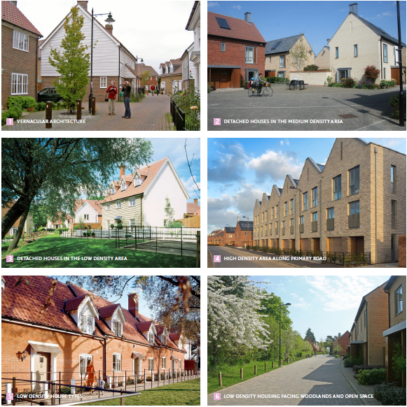
The overall housing density will remain low with semi-detached and detached houses being the predominant housing typology to reflect the existing village context. The overall setting will be compact to create and encourage a strong sense of community.
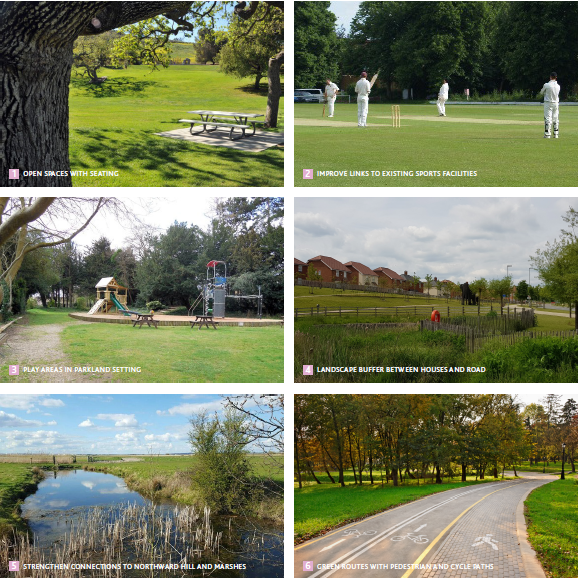
Open Spaces & Pedestrian Connectivity
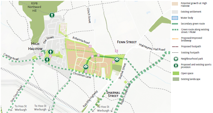
- New green routes linking High Halstow and Hoo St Werburgh, using existing footpaths and roads and encourage pedestrian connections within the wider Hoo area. The green route along Dux Court Road forms part of the Strategic Environmental Management Scheme (SEMS) and connects with the proposed Lodge Hill Community Parkland.
- The proposed green routes also connect with RSPB Northward Hill and the marshes to the north of High Halstow.
- New neighbourhood parks to complement the existing network of open spaces.
- Further detailed work is needed to plan for open space requirements.
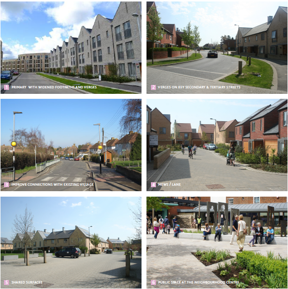
Healthy Streets & Public Transport
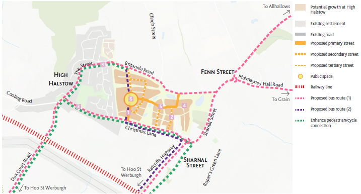
- Primary access from Christmas Lane through the proposed neighbourhood centre. Potential upgrades to Christmas Lane to support the scale of new development.
- Potential public space at the heart of the new neighbourhood centre.
- Potential new bus route connecting High Halstow with Hoo St Werburgh via the proposed schools at Ropers Lane and the planned rail station.
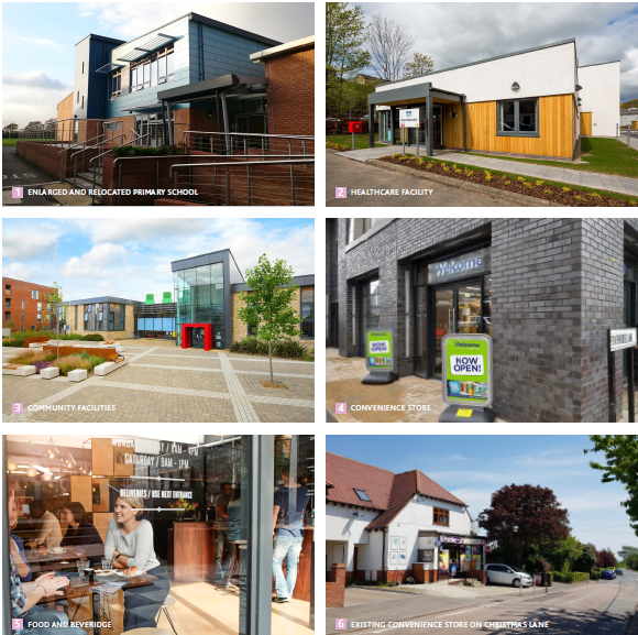
Community Facilities and Services
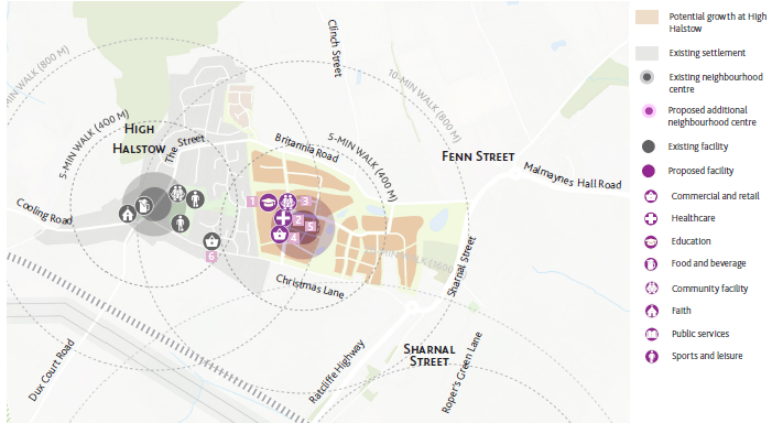
- New neighbourhood centre to co-exist with and complement the existing historic centre, with facilities evenly distributed between the two centres. The majority of the enlarged High Halstow settlement will be within a 10-minute walk of either neighbourhood centre, making key services accessible.
- Potential for small-scale public and community facilities, which do not detract from or compete with the existing facilities at High Halstow.
- Expansion by 1-form entry and relocated High Halstow Primary School into the new neighbourhood centre.
Built Form
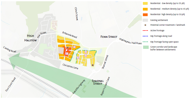
- Green corridor and landscape buffer between High Halstow and Hoo St Werburgh to prevent coalescence of built-up areas and maintaining long distance views of the south. Sensitive and high-quality design to be encouraged to maintain the distinct character and identity of High Halstow.
- High density development limited to the neighbourhood centre, incorporating a mix of uses, including small-scale retail and community facilities.
- Gradual decrease in housing density to the north and east, with options for self-build and custom housing to extend range of housing.
- Maximum building height of 2 - 3 storeys to conform with the character of the existing High Halstow settlement.
- Active frontages at the neighbourhood centre along the primary street
- Key frontages facing the open space, which forms a primary green route. Sensitive edge facing the ancient woodland at Sharnal Street.
- Potential for a small-scale building with landmark features at the Ratcliffe Highway / Christmas Lane / Sharnal Street roundabout, to mark the entry to High Halstow from Hoo St Werburgh.
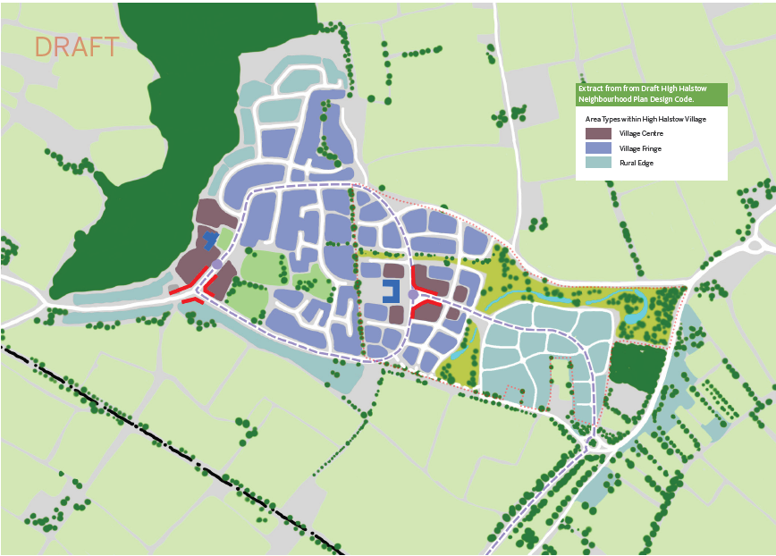
5.7 High Halstow Neighbourhood plan
Design Code & Neighbourhood Plan
High Halstow Parish Council is preparing a Neighbourhood Plan. It has consulted on an early draft of the plan. In autumn 2021 High Halstow Parish Council produced a Design Code to support the draft High Halstow Neighbourhood Plan policies. The Design Code sits alongside the emerging High Halstow Parish Neighbourhood Plan, consolidating its vision and design principles to provide specific commitments for development approvals. Extracts from the draft High Halstow Design Code are shown opposite. The Design Code is supporting work for the Neighbourhood Plan, and there will be further consultation and an independent examination before the content of policies and design guidelines are confirmed.
The document guides designers and developers to meet the aspirations of the existing High Halstow community and ensure that design proposals are of high quality and integrate well with the existing village and surrounding landscape.
The High Halstow Design Code follows the National Model Design Code process of understanding the existing context of the area and setting design codes across each of the key themes of:
- Movement;
- Nature;
- Built Form;
- Identity;
- Public Space;
- Use;
- Homes and Buildings;
- Resources; and
- Lifespan
The High Halstow Design Code aligns in principle with Hoo Development Framework. The key discrepancies are around the main access route from south-east alignment and densities distribution. These details are to be confirmed within the course of community consultations later this year.
The extracts from the draft High Halstow Design Code have been published in the Hoo Development Framework consultation document, so that there is an opportunity to compare approaches, and progress further consultation.
For further information on the High Halstow Neighbourhood Plan, please see the dedicated website: highhalstowneighbourhoodplan.co.uk