High Halstow Neighbourhood Plan - Regulation 16
2. High Halstow 'today'
The neighbourhood plan area
2.1 The Neighbourhood Plan area covers the entire parish of High Halstow. The Parish is located on the north side of the Hoo Peninsula in Medway. The neighbourhood boundary for High Halstow is quite expansive and extends to the River Thames to the north.
2.2 Despite the large neighbourhood area, the main concentration of existing development – the village of High Halstow itself - is located in the middle of the Parish, to the north of an existing freight railway that runs east-west through the parish.
2.3 The main access routes into the Village are via Christmas Lane, Britannia Road and Dux Court Road; they both merge with The Street where the main amenities and local facilities are located that serve the parish. These facilities include; the Primary and pre School, Village Hall, War Memorial Hall, Sport Field, Village Shop/Post Office, The Red Dog Pub and St Margaret's Church.
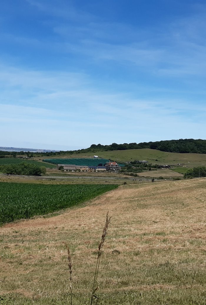
2.4 High Halstow is rural in character and benefits from open countryside that separates High Halstow from the other rural villages located on the Hoo Peninsula; Cooling, Cliffe &,Cliffe Woods, Hoo, St Mary Hoo, Stoke, Lower Stoke, Grain and Allhallows. Its landscape encompasses areas of marsh and farmland. Unlike other parishes on the peninsula more strongly affected by the industrialisation of the Thames and Medway during the 19th and 20th centuries, its character remains predominately rural, with a number of dispersed farmsteads.
2.5 The northern third of the area is occupied by an expanse of low-lying reclaimed marshland. This area is the Halstow Marshes and is designated as a Special Protection Area (Thames Estuary & Marshes SPA), which further emphasises the important character and qualities of the environment in this area. Furthermore, the marshes surrounding the Hoo Peninsula are also designated as a Ramsar Site and a Site of Special Scientific Interest (SSSI) (Medway Estuary & Marshes). Northward Hill and Dalham Farm are also designated as SSSIs. In addition, Northward Hill is also designated as a National Nature Reserve. This is a highly sensitive and protected environment, particularly for Herons, a colony of white-letter hairstreak butterflies and rare ruddy darter dragonfly, benefiting from international designations. It is noted in the Medway Landscape Character Assessment3 that Northward Hill already has rural fringe pressures to the south due to its proximity to the settlement of High Halstow village.
2.6 The main settlement of the village of High Halstow lies below the crest of Northward Hill and wraps around the southern edge of the nature reserve. This principal settlement within the Neighbourhood Area was established in the Saxon period. The name 'Halstow' signifies a holy place, while 'High' was adopted to distinguish it from Lower Halstow and it also describes the topographical situation of High Halstow. The village has a pronounced high point affording long distance views beyond the administrative boundary of High Halstow. Land to the rear of Marsh Crescent to the north of the settlement benefits from views of the Marshes and on a clear day views extend as far as London. To the south and west of the Parish lies the former Deangate golf course and part of the Lodge Hill former army camp. This area provides nesting for the largest population of breeding nightingales in the UK – a unique resource to be preserved and protected from the impacts of development.
Demographic profile
2.7 The parish has a population of 1,846 people living in 714 households4. This equates to an average household size of 2.56 people per household. Most households are either owned with a mortgage or loan (47.1% of all High Halstow Households) or owned outright (43.1% of all High Halstow Households). Cumulatively, that equates to 90.2% which is much higher than the national average, which is around 65%. The median house price in High Halstow, as of 2018, is £391,000, in comparison to £229,000 in 20155. The most prominent household type in the Parish is a detached house or bungalow, comprising 51.6% of the total housing stock.
2.8 The largest age-group in the Parish is the 45 to 59 group, accounting for 24.3% of the total population of High Halstow3. As noted in the Medway Village Infrastructure Audit (2017)6 there is an ageing population across the rural areas on the Hoo Peninsula, and the Kent and Medway Growth and Infrastructure Framework (2018) states that in Kent and Medway, the population over 65 is expected to increase by 81.5% in 2050. At present, the majority of residents in High Halstow are reported as being in good or very good health (combined total of 81.6% of the population). This is reflective of the national picture. However, the ageing population demographic may bring about new and diverse need, some may require high levels of specialist care and housing, while others will live more active lives7.
2.9 Medway's total household population is expected to increase by more than 15,000 people between 2018 and 20438, and the emerging Local Plan makes provision for significant future growth across the Hoo Peninsula, as well as in High Halstow.
2.10 In regards to educational attainment in the parish, the largest group of educational qualifications achieved by the population are level 4 qualifications (University Degree) and above at 23.87%, in comparison to 18.66% of High Halstow's residents whom are recorded as having no qualifications. Despite the majority of residents having a level 4 qualification or higher, this is lower than the national average (at 27.2%), but higher than that across Medway as a whole (with an average 19.1% of residents with a level 4 qualification). Thus, at the local level, High Halstow has a relatively high level of educational attainment.
2.11 The majority of the High Halstow population travel to work by car (76%) and the second highest form of transport being by bus (5%). The majority of residents work in either Wholesale, Retail Trade and Repair industries. In the Medway Employment Land Needs Assessment 2015 it states that the Hoo Peninsula is predominately characterised as an area of Power Stations, Petrochemical plants, specialised and heavy industries, although this has changed in more recent times with the de- commissioning and demolition of large coal fired power stations.
2.12 Wider analysis of Medway as a whole states that whilst some of the traditional manufacturing and port activities have been lost, a number of advanced manufacturing activities have remained and expanded. The area also has attracted a range of 'new' sectors from financial and business services through to software and gaming development. Overall, there is a need to deliver a mix of industrial and warehousing stock over the plan period to enable the borough to capitalise on the economic opportunities while also addressing the shifting nature of the Medway economy by providing a reasonable scale of office floorspace. Although the Employment Land Needs Assessment is a high level document and is not specific to High Halstow the changing economic market should be acknowledged to ensure future development within the neighbourhood area is sustainable.
Growth and development
2.13 As noted in the previous section, the population of the Parish is 1,846. The village remained relatively small until just after the second world war when it experienced rapid growth, after which the population and extent of the built area has remained relatively stable, as illustrated in Figure 3.
2.14 The proportion of dwellings in High Halstow that were built after 1945 is around 85% and this growth was driven by power generation and the Isle of Grain oil refinery: the owners of whom built houses in the village to house their employees.
2.15 Since the Local Plan for Medway was adopted in 2003 two large power stations have closed and there has been more limited growth in the area. However, the emerging Local Plan envisages major change which is linked to Medway Council having successfully been awarded grant funding from Central Government through the Housing Infrastructure Fund (HIF).
2.16 Through the HIF Medway Council hopes to "unlock the potential" of the Hoo Peninsula. This envisages major new growth and development on the Peninsula, improved road and rail connections through upgrades to the existing freight railway line for use by passengers and potentially a new road to reduce pressure on the A228 and Four Elms roundabout. It is anticipated that these "improvements" will be in place by 2025. A new passenger station, located to the south of High Halstow parish, will provide a new means of access into London. Medway Council anticipate that the station will help facilitate new housing development elsewhere on the Peninsula, as well as within High Halstow.
2.17 Land to the east of High Halstow and Land at Walnut Tree Farm has been identified for growth and development by developers Redrow and an application for planning permission is expected imminently. Land at Walnut Tree Farm is now completed, providing 66 new homes. Land to the east of High Halstow is a strategic site where approximately 760 new homes and supporting infrastructure is proposed, doubling the size of the village and its community through a single development proposal. This site is located between the main settlement of High Halstow and Fisher's Wood, and between Christmas Lane and Britannia Road.
2.18 There is concern within the community as to the scale of growth proposed and the impact this will have on High Halstow. However, this Neighbourhood Plan can, and does, seek to put in place policies that shape any future growth such that it best meets the needs of the community and responds to the identity and character of High Halstow.

What you told us
2.19 The consultation exercises undertaken identified a range of issues of importance for addressing in the Neighbourhood Plan. Consultation exercises suggested that:
- The rural, village feel of High Halstow should be retained, with fields kept for agricultural use, and open spaces protected. Important environmental areas and designations, including parks and wildlife areas, should be retained.
- Any new development should respect the village feel, should be of a high quality of design and meet local needs, including provision of a mix of types of homes, including houses, bungalows, affordable homes and opportunities for self-build.
- Local services and facilities should be improved, including provision of a daily doctor's surgery with regular staff attendance, and an enlarged or new primary school which all pupils in the village can attend, reducing the need to travel to school outside of High Halstow
- Accessibility and movement, by all modes of travel, should be improved, including improved bus services (particularly in the evening), traffic calming measures, better maintenance of access roads to the village, and better road access to the Hoo Peninsula.
2.20 Although not all of these are 'land-use planning policy' matters, they do reflect the community's concerns and hopes for the area, and are thus embedded in this Neighbourhood Plan through a combination of the vision, objectives and supporting projects.
The development plan
2.21 Neighbourhood Plans must be prepared in line with national guidance and legislation including the Localism Act (2011), the Neighbourhood Planning (General) Regulations (2012)9, the Neighbourhood Planning Act, the National Planning Policy Framework (NPPF) (2021) and National Planning Practice Guidance (NPPG).
2.22 Neighbourhood Plans must be in general conformity with the strategic policies of the development plan. The development plan for High Halstow is the Medway Local Plan, which was adopted by Medway Council in 2003.
2.23 The Policies Map that sits alongside the adopted Medway Local Plan 2003 indicates that for High Halstow:
- Only minor development should take place within the settlement boundary.
- Loss of shopping facilities and other supporting community facilities within village centres will be restricted.
- Development should be avoided in areas of landscape value, international and national nature conservation sites or within close proximity to where such development would cause harm to those sites.
- The impact on rural lanes, their amenity, landscape and historic significance should be minimised. Within the Parish, Cooling Road and Dux Court Road are both marked as rural lanes.
2.24 These policies will be superseded in due course as the Medway Local Plan is currently being updated, with consultation on the Regulation 18 version development strategy document undertaken between March and June 201810. A pre-submission consultation version of the Local Plan was published in October 2021 for approval by Full Council but was subsequently withdrawn. At the time of writing, there are no updates on the timeframe for next steps although, once adopted, the new Local Plan will cover the period 2019 to 2037.
2.25 For the Neighbourhood Plan to remain relevant it is important that it aligns with the strategic policies established in the emerging Local Plan. However, as things stand there is no emerging Local Plan and therefore no strategic policies. Nevertheless, High Halstow may still need to accommodate additional growth; linked to the successful bid for HIF funding, as developers are now proposing to submit applications for planning permission for new housing to the east of the village (the Land East of High Halstow: "LEHH").
2.26 The Neighbourhood Plan seeks to put in place policies that shape and influence any new growth and development, including that which is small in scale, within the current built envelope of the village, and in sustainable locations identified in the Local Plan. This is so that development responds to the qualities of High Halstow and concerns expressed by the community, including the importance of local infrastructure delivery and sensitivity to the landscape setting of High Halstow, its rich environment and important wildlife habitats.
2.27 This Neighbourhood Plan also includes site specific policies in respect of the LEHH site. However proposals for the LEHH site should not proceed in advance of the adoption of the Local Plan, and should be subject to commitment to delivery of the future strategic infrastructure proposals, and if the LEHH is to proceed, it should do so only when the Local Plan and the strategic infrastructure, including but not limited to the HIF projects, is in place.
2.28 Alongside the emerging Local Plan, and informing this, Medway Council has prepared a vision (March 2020) and subsequent and development framework (September 2021) illustrating how growth could come forward on the Hoo Peninsula over the next twenty years11. Growth is shown in the vision document as taking place to the east of High Halstow, with green buffers retaining the separate identity of High Halstow from growth to the south (beyond the natural crest of the village to the boundary of Hoo Parish running from the southeast High Halstow boundary to the southwest boundary) and thus retaining its tranquil landscape setting. It proposes that improved connections will be provided between the village and the new railway station, with relatively low density development on land to the east of the village, though with an area of high density development focused around new community facilities. The vision and associated framework are non-statutory documents and future development proposals will be subject to environment and other necessary assessments as appropriate to the scale and location of the proposal.
2.29 Other relevant policy documents include:
- National Planning Policy Framework: July 2021, sets out the Government policy. It is a material consideration in planning decisions.
- Medway Housing Design Standards, adopted as a Supplementary Planning Document (SPD) in November 2011, and which includes guidance on matters such as dwelling size, amenity space, circulation, storage, refuse, visual privacy, landscape and building management.
- Medway Guide to Developer Contributions and Obligations, adopted as SPD in May 2018, setting out the contributions to infrastructure required from developments of ten dwellings or more. Where a site triggers the requirement for affordable housing, but this cannot be delivered on site, then Medway Council has a commuted sums policy which should be used.
- The Strategic Access Management and Monitoring Strategy, published in 2014, which sets out a strategy for resolving disturbance caused by development on the wintering and migrating birds in North Kent.
Climate Change
2.30 This Neighbourhood Plan is set in the context of the Climate Change Emergency declared by Medway Council in April 2019. Medway Council is committed to reducing its carbon footprint and to provide the local community with a clean, green future and to be a place that people want to work and live, and which has a sustainable future.
2.31 A Climate Change Action Plan was published by Medway Council in June 2021. This sets out eleven priority areas. For planning and development, these include the promotion of sustainable forms and patterns of development, supporting sustainable transport solutions, low carbon buildings and sustainable drainage. .
2.32 The importance of planning for change in High Halstow is emphasised through visualisation of the carbon footprint of the Parish which, on a per annum basis averaged across all households, far exceeds that for Medway as a whole, with road transport and housing accounting for 65% of all emissions in the Parish (see Figure 4)12. Indeed, it is these two categories that account for the significant difference in the carbon footprints between High Halstow and the Medway area. Tackling these through a combination of planning policy and projects, as well as other initiatives outside of the planning framework, is key to reducing emissions and helping to mitigate against the impacts of climate change.
2.33 High Halstow is a village that was built to serve the oil industry but now aspires to be carbon neutral. This Neighbourhood Plan seeks to promote high quality, eco-friendly design and development that respects the environmental qualities and landscape setting of the parish, embedding sustainable design and construction techniques in new development and the retrofitting and refurbishment of existing buildings. It promotes walking, cycling and better public transport facilities and seeks to protect and enhance local environmental features, as well as the full range of services and facilities in High Halstow that serve the community and make this an attractive place to live.
2.34 Policies, projects and aspirations are included in the Neighbourhood Plan that seek to deliver a more environmentally responsible future. It is though recognised that this is a rapidly evolving area, with national policy and guidance emerging, as well as actions coming out from Medway Council. As these become formalised so the Neighbourhood Plan will be reviewed.
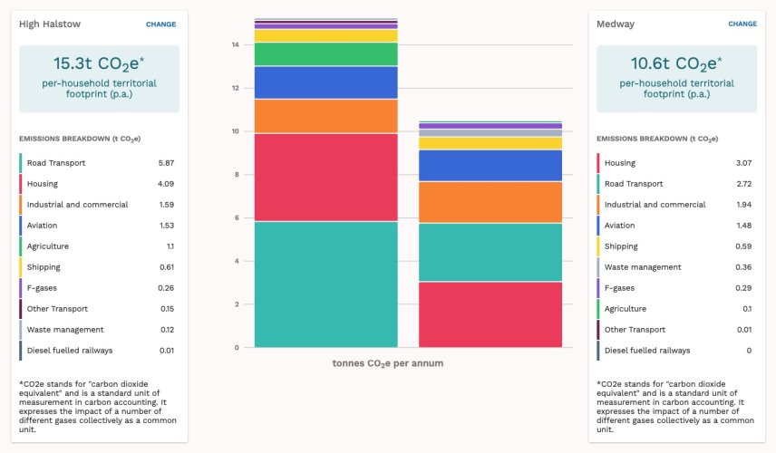
Figure 4: High Halstow carbon footprint (per household, per annum) in comparison with the footprint for Medway (source: IMPACT Community Carbon Calculator)
Reviewing the Neighbourhood Plan
2.35 Notwithstanding the defined period of the Neighbourhood Plan to 2037, it is recognised that, with publication of the Local Plan at some point in the future and further national guidance likely, the Neighbourhood Plan will need to be reviewed periodically. This will enable the Neighbourhood Plan to remain 'current' and in conformity with the Medway Plan and National Planning Policy Framework.
3 Medway Council. March 2011, Medway Landscape Character Assessment
4 Office for National Statistics. High Halstow Parish Local Area Report. Available at: https://www.nomisweb.co.uk/reports/localarea?compare=E04001135
5 Consumer Data Research Centre (CDRC). House Price 2015 and House Price 2018 (Median 1 Y rolling) maps. Available at:
https://maps.cdrc.ac.uk/#/metrics/ruralurban/default/BTTTFFT/10/-0.1500/51.5200/6Medway Council (2017) Medway Village Infrastructure Audit.
7 Kent County Council and Arup, 2018, A 2050 Picture of Kent and Medway, Update of the Kent and Medway Growth and Infrastructure Framework. Available at: https://www.kent.gov.uk/data/assets/pdf_file/0009/79920/GIF-2050-Picture.pdf 8 ONS, 2018-based Population Projections for Local Authorities, Table 2
8 ONS, 2018-based Population Projections for Local Authorities, Table 2
9 Updated in 2015 and 2016
11 Medway Council, March 2020, Planning for Growth on the Hoo Peninsula, and, Medway Council, September 2021, Hoo Development Framework
12 Data taken from IMPACT Community Carbon Calculator, developed by Centre for Sustainable Energy and partners. The footprint is expressed as 'carbon dioxide equivalent' tonnes and is a standard unit of measurement in carbon accounting. It expresses the impact of a number of different gases collectively as a common unit. More information can be found via the IMPACT website: https://impact- tool.org.uk/