High Halstow Neighbourhood Plan - Regulation 16
5. Environment
5.1 The policies and projects contained within this section of the Neighbourhood Plan relate to the objectives below and are summarised in Figure 7:
Objective 02:
To preserve and improve sympathetic access to existing green spaces and further provide additional green spaces within the developed environment.
Objective 04:
To keep High Halstow a rural village
Objective 07:
To provide a sustainable environment for the residents and wildlife of High Halstow whilst being mindful of conserving an ecological balance.
Natural habitats and biodiversity
5.2 The landscape setting and character of High Halstow parish is defined by the network of open space habitats, fields, trees, hedges and streams. The Kent Historic Area Assessment (2014) characterises much of the parish as being marshland, farmland and woodland, with limited settlement areas.
5.3 The northern part of the parish, along the Thames, comprises marshland and is designated as a Special Protection Area, Ramsar Site and a Site of Special Scientific Interest (SSSIs) (Figure 8). Northward Hill and Dalham Hill are also designated as SSSIs. Furthermore, Northward Hill is a National Nature Reserve (as declared in 1951) managed by the Royal Society for the Protection of Birds. It is one of the higher points on the Hoo Peninsula and affords long distance views into London and across the greater Thames Estuary. Northward Hill is covered by a mixture of hawthorn scrub and ancient oak woodland, as well as a bluebell wood. It is the largest heronry in the UK with more than 150 pairs of grey heron nesting in the treetops and almost 50 pairs of little egrets. It is also home to nightingales, whitethroats and turtledoves18.

Figure 7: Indicative concept plan showing summary of aspirations for the environment, green space and landscape setting of High Halstow (image source: Google Earth)

Figure 8: Environmental and heritage designations in and around High Halstow parish and the wider Hoo Peninsula (source: Defra / MAGIC)
5.4 To the south west of the Parish lies the former Deangate Golf Course and Lodge Hill former army camp, now designated as SSSI on account of it housing the largest number of breeding nightingales in the UK.
5.5 The Medway Landscape Character Assessment19 states that Northward Hill is already experiencing rural fringe pressures to the south due to its proximity to the settlement of High Halstow village. This Assessment goes on to state that any large scale strategic growth on the Hoo Peninsula farmland must protect the rural character and openness of the countryside between villages at Cooling, St Mary Hoo, Cliffe, Cliffe Woods, Hoo, High Halstow, Stoke, Lower Stoke and Allhallows. Dalham Hill is said to illustrate 'what is possibly the lowest angles slope failure in Great Britain and is important in demonstrating slope degradation in the absence of coastal erosion and removal of material from the base'20.
5.6 To the south-eastern edge of the village the Hoo Peninsula farmland is flat or undulating open farmland. The underlying clay soil, with a subsoil of gravel, has historically been used for arable farming, with grazing on the marshes.
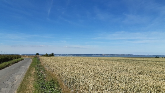
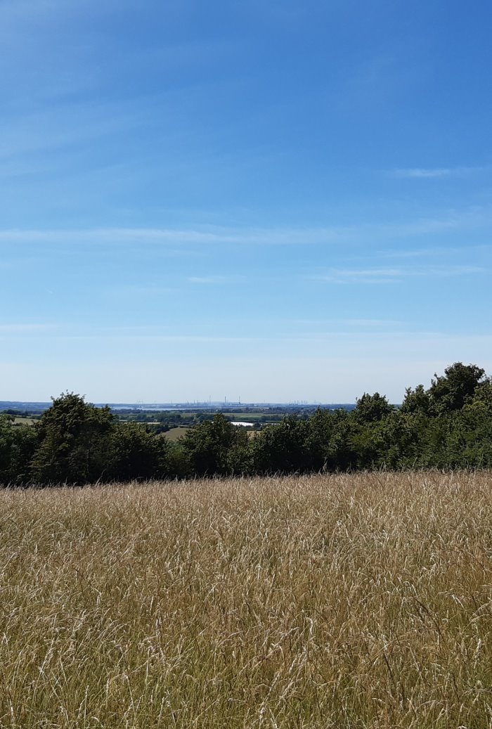
Figure 9: Views out across the High Halstow countryside towards the Thames Estuary
5.7 The RSPB has advised that the Greater Thames Estuary is one of the most important wildlife sites in Europe and is home to nationally important populations of breeding waders, beach-nesting birds, nightingales and rare invertebrates. It is a major feeding hub for birds using the East Atlantic flyway, hosting the largest aggregation of wintering waterfowl in the UK with 75% of all the breeding waders in the South East of England found on the North Kent Marshes.
5.8 The Estuary is severely threatened by a combination of development, recreational disturbance, habitat fragmentation, sea level rise and other impacts of climate change. The Hoo Peninsula is one of the largest and most important parts of this landscape, with extensive areas of SSSI/SPA grazing marsh, saltmarsh and mudflats.
5.9 The RSPB's Northward Hill reserve has high densities of breeding lapwing and redshank, one of the largest avocet colonies in the UK, one of the UK's largest heron colonies and the second largest nightingale population on an RSPB reserve. The number of nightingales in the UK has dropped by 93% over the last 40 years according to the British Trust for Ornithology. As ground and scrub-nesting birds they are especially vulnerable to predation and disturbance by domestic animals and walkers. Buffer zones, free from development, around nesting areas at Northwood Hill are fully justified.21
5.10 The entirety of the parish is within the Impact Risk Zone of a SSSI as defined by Natural England. All proposals for development within the parish will thus be subject to consultation with Natural England and trigger the need for Habitats Regulation Assessment.
5.11 The entirety of the parish is also within a six kilometre catchment of the Special Protection Area. In this area the Interim Policy Statement adopted by Medway Council (2015) in respect of Strategic Access Management and Mitigation applies (and until such time as it is updated or replaced). A financial contribution is payable to the Council for all new homes built in this area, which will be used to mitigate the impacts of population increases on the SPA.
5.12 To preserve the quality of the natural environment any proposals impacting on the SPA will be required to demonstrate that any potential impacts have been assessed and identify any mitigation measures required to offset these. All development should result in a net biodiversity gain and improvement to the quality of habitats. A minimum 10% bio-diversity net-gain should be aimed for, based on use of the most up-to-date version of the Natural England Bio-Diversity Metric22 (version 3.1 at time of writing). Off-site provision is not preferred but where it is the only practical solution must remain as close as possible to the development site.
5.13 The natural environment of the parish and wider peninsula is highly sensitive and important nationally (and internationally). Until such time as the Medway Local Plan is updated a precautionary approach shall be taken to planning and development in the parish.
Policy HH E1: Natural Environment
- All development in the Parish will be subject to payment of contributions as contained in the Medway Strategic Access Management and Mitigation Strategy. All proposals will be subject to consultation with Natural England and will need to demonstrate that the proposals, either alone or in combination with other plans or projects, will not adversely affect the integrity of a designated European or RAMSAR site.
- Development will be expected to retain and enhance well-established natural habitats, including mature trees, hedgerows and water features. All development will be required to result in a minimum net biodiversity gain of 10%, calculated based on use of the Natural England Biodiversity Metric v3.1 (or any subsequent updates to this) and submission of a biodiversity net gain plan submitted as part of the planning application. This applies to all developments, including smaller sites, which should make use of the Small Sites Toolkit published by Natural England as part of the biodiversity metric. The management plan should show how it is proposed to managed biodiversity net gains in perpetuity.
- Any proposal involving the removal of natural environmental features must be justified and will be required to clearly demonstrate how the benefits from development will outweigh the negative impacts to the natural environment.
- If there is significant loss of trees and shrubs as part of development, then new provision will be expected elsewhere on the site or, if not possible on site, then elsewhere within the parish, providing equivalent coverage and an acceptable contribution towards the natural environment and local character.
- Development on the edges of the settlement must avoid abrupt edges that lack vegetation or landscaping. In sensitive environmental locations provision of comprehensive landscape buffering is encouraged. Native trees and shrubs must be used that reinforce the rural character of the area.
Policy HH E2: Countryside and Rural Landscape
- The open countryside around the built up area of High Halstow is of high landscape value and will be treated as a "Valued Landscape" within the meaning of the NPPF and any development will be required to demonstrate how it protects and enhances its landscape character.
- Much of it is of special importance because of landscape, archaeological and nature conservation interest, their local amenity value and their importance to the setting of historic, ecological or wider landscape features.
- Within this area, development will be considered in relation to the extent to which its location, scale, design and materials would protect the local landscape character and enhance the future appearance of the landscape and its nature conservation interest.
- Development proposals which would cause unacceptable harm to the local landscape character, archaeological or nature conservation interest will not be permitted.
- Much of the local countryside is also Grade 1 and 2 Best and Most Versatile agricultural land, including traditional orchards. Development proposals that lead to the loss of such land will only be allowed where it has been demonstrated that land of lower landscape and agricultural value is not available elsewhere in the district. Development is expected to enhance local landscape character, archeological and nature conservation where appropriate to the site.
- Equestrian development will be permitted where it is shown that it will not cause harm to landscape character and biodiversity.
Settlement identity and views
5.14 High Halstow benefits from a clearly defined identity as a rural village. This is in part due to its settlement envelope being established by green "buffers" of woodland and fields. The importance of this in enhancing local distinctiveness is recognised in the Medway Landscape Character Assessment23, which notes that within the Hoo Peninsula Farmland character area, the suburbanisation of villages and settlements should be resisted, and that the separation, rural character and openness of the countryside between villages shall be protected. Green wedges are identified (Figure 10) between Christmas Lane and the railway line, and along the A228 Ratcliffe Highway, which are intended to retain the separate identities of High Halstow village from Hoo St Werburgh and Sharnal Street respectively. This is supported in the Landscape Sensitivity and Capacity Study24 which notes that land to the south of High Halstow forms a 'valuable functional role in separating and retaining local identity of communities at High Halstow and Hoo St Werburgh'. It recommends that it is retained as an 'anti-coalescent gap'. To the east, the study notes the importance of retaining a separation between 'an enlarged High Halstow and Sharnal Street', and that it offers a 'potential anti-coalescent and Green Infrastructure buffer'.
5.15 The parish is an area of undulating and predominantly arable farmland with extensive long distance views, and where there is a risk of settlement coalescence. Indeed, the dramatic setting of the village as a hill-top settlement contrasts with the extensive open marshland and rolling countryside across much of the parish.
5.16 This is reflected upon in the Medway Heritage Asset Review25 which comments on the historic growth and evolution of the area, noting that 'additional late twentieth century housing development infilled the north-east and eastern areas of the village, between Christmas Lane and Britannia Road, leaving much of the historical character of High Halstow evident within the dispersed upland farmsteads'.
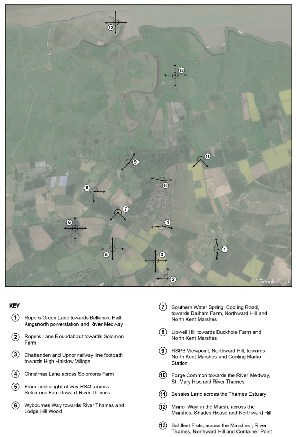
5.17 Key views in the parish which development should not intrude upon are illustrated in Figure 11 and expanded upon in Appendix 1. The Landscape Character Assessment recommends that where new development is proposed, it should respect and enhance biodiversity and local distinctiveness, providing new hedgerows and screening to settlement edges which help harmonise the development with the countryside. The importance of views is also highlighted in the Landscape Sensitivity and Capacity Study, which notes the long, expansive and distinctive views extending to the estuary, its open landscape, distinctive and visually prominent topography.
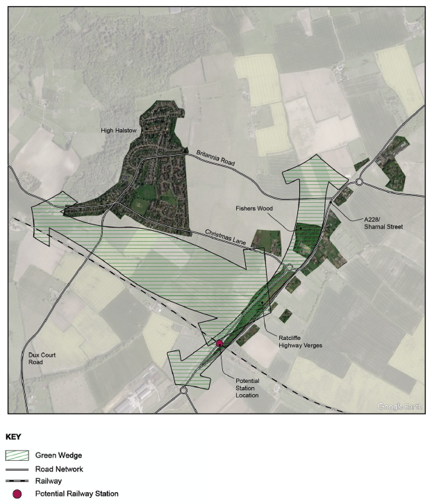
Figure 10: Green wedges in High Halstow (map source: Google Earth) Note: more recent plans prepared by Medway Council indicate that the location of the station is likely to be further east of the Ratcliffe Highway than indicated in this figure.
Policy HH E3: Settlement Identity
- Proposals for development shall respect the separate identity of High Halstow village and Sharnal Street.
- Green wedges, as indicated on Figure 11, between (i) Christmas Lane and the railway line, and (ii) from Fishers Wood, extending north and south alongside the A228, shall be retained.
- Development adjacent to these areas will enhance biodiversity and local distinctiveness, and include screening at settlement edges that incorporate native species.
Policy HH E4: Important views
- Proposals for development shall not have a significant adverse impact on the important views identified on Figure 11 and listed below. Any development proposed within the views shall demonstrate how any impacts on those views are minimised.
- Ropers Green Lane towards Belluncle Halt, Kingsnorth Power Station and River Medway.
- Ropers Lane roundabout towards Solomons Farm.
- Chattenden and Upnor railway line footpath towards High Halstow village.
- Christmas Lane across Solomons Farm.
- From public right of way RS45 across Solomons Farm towards River Thames.
- Wybournes Way towards River Thames and Lodge Hill Wood.
- Southern Water Spring, Cooling Road, towards Dalham Farm, Northward Hill and North Kent Marshes.
- Lipwell Hill towards Buckhole Farm and North Kent Marshes.
- RSPB Viewpoint, Northward Hill, towards North Kent Marshes and Cooling Radio Station.
- Forge Common towards the River Medway, St. Mary Hoo and River Thames.
- Bessies Land across the Thames Estuary.
- Manor Way, in the Marsh, across the Marshes, Shades House and Northward Hill.
- Saltfleet Flats, across the Marshes, River Thames, Northward Hill and Container Port.
Local Green Space designations
5.18 Under the NPPF, Neighbourhood Plans can designate Local Green Spaces which are of importance to the local community. The NPPF states that Local Green Spaces should only be designated where the green space is:
a) in reasonably close proximity to the community it serves;
b) demonstrably special to a local community and holds a particular local significance, for example because of its beauty, historic significance, recreational value (including as a playing field), tranquillity or richness of its wildlife; and
c) local in character and is not an extensive tract of land. 26
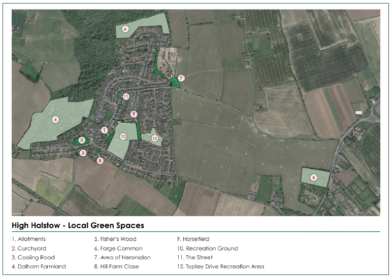
5.19 The Local Green Spaces listed in Policy HH E5 and mapped in Figure 12 are all considered to meet the criteria for designation outlined in the NPPF. More information on these is presented in Appendix 2.
Policy HH E5: Local Green Spaces
- The following areas are designated as Local Green Spaces, as identified on Figure 12 and in more detail in Appendix 2:
- Allotments
- Churchyard
- Cooling Road (Front of churchyard & triangle)
- Dalham Farmland (SSSI)
- Fisherwood
- Forge Common
- Heronsdon (Copse & frontage)
- Hill Farm Close
- Horsefield (adjacent to recreation Ground)
- Recreation Ground and Cricket Field
- The Street (strip of land between it and Eden Road and grass verges to south)
- Topley Drive Recreation Area
- Planning applications for development on the Local Green Space Designations will not be permitted unless exceptional circumstances can be demonstrated and where the proposed development performs a supplementary and supporting function to the Green Space. Exceptional circumstances are to be taken as those defined in relation to the Green Belt in the NPPF.
- Proposals to improve and enhance the biodiversity value of the spaces will be welcome, including opportunities to deliver biodiversity net gains.
New green space and sustainable drainage
5.20 Within areas of new development, open space and playing pitches should be provided in line with identified needs and local standards. These facilities play a vital role in creating a positive environment, fostering community cohesion and gathering. Furthermore, and in light of the recent COVID-19 pandemic, the importance of local and accessible green spaces for leisure and recreation was highlighted.
5.21 Where new spaces are to be provided principles set out in the High Halstow Design Code should be referred to and complied with in full. Such spaces should be safe, accessible and usable for all, and provide a range of open space types and play facilities that cater for all ages. Green spaces should be connected by a network of green infrastructure, including public rights of way, tree-lined and landscaped streets. This network of spaces should incorporate measures that help manage surface water run-off and include wildflowers enabling insect pollinators to extend their range.
Policy HH E6: New green spaces
- Development of a scale that triggers provision of new green space should be provided in line with standards established by Medway Council. The design of this space should reflect the principles established in the accompanying High Halstow Design Code.
- Development should:
- Avoid creation of left over space that lacks purpose.
- Integrate open space within the development rather than pushing this to the periphery.
- Locate new green space within walking distance of as many residents as possible.
- Link green spaces through a network of green routes wherever possible, including public rights of way and tree-lined or landscaped streets.
- Provide a range of open space types, including areas of play, opportunities for growing food, and quieter areas for relaxation.
- Ensure that play areas and public spaces are well overlooked wherever possible, providing natural surveillance of the space. Hidden spots must be avoided.
- Enable play spaces to be accessible for all children and incorporate elements relating to nature and landscape as well as play equipment.
- A connected network of green spaces that incorporates measures that minimise surface water run-off and which help extend the range of insect pollinators is supported.
5.22 Where sustainable urban drainage systems (SuDS) are provided they must be incorporated within the network of open spaces and green infrastructure linking these and can take a variety of forms, including attenuation ponds, rain gardens and other measures such as green walls and roofs that minimise surface water run-off. Guidance prepared on behalf of the lead local flood authorities in the South East of England27 (and used by Medway Council) shall be referred to when designing SuDS.
Policy HH E7: Flood risk
- Proposals for development must incorporate measures that manage and minimise flood risk and surface water run-off. SuDS should be incorporated in and form an integral part of new open space and the network of green infrastructure wherever possible. These should be designed in line with guidance from Medway Council and may incorporate, but not be limited to, the following measures:
- Attenuation ponds.
- Raingardens within the urban realm.
- Green walls and roofs.
- Permeable surfaces in areas of parking.
- Planting of trees.
- Where SuDs are to be provided they should be designed such that they are in harmony with the surrounding landscape.
Towards zero-carbon development
5.23 Most carbon dioxide emissions come from heating, cooling and powering buildings. Reducing carbon dioxide emissions and other air pollutants will contribute to efforts aimed at tackling the effects of man-made climate change. This is recognised by the declaration of the Medway Climate Emergency and publication of a draft Action Plan which seeks to reduce the Council's own carbon emissions and supports actions to help others work towards net zero emissions. At the same time, the Government is planning to introduce a 'Future Homes Standard', requiring new build homes to be future-proofed with low carbon heating and energy efficiencies. It is anticipated that the Future Homes Standards will be implemented by 2025.
5.24 The growth of High Halstow may represent an opportunity to provide housing that enjoys reduced emissions, potentially through the construction of highly energy efficient buildings, the provision of decentralised energy networks alongside, where possible, the retrofitting of existing homes to reduce their energy use and fuel bills. Opportunities for new homes and the retrofitting of existing buildings are set out in the forthcoming High Halstow Design Code.
5.25 All development in High Halstow will be expected to make use of the best available sustainable design and technology. Proposals for development are expected to minimise the use of resources, mitigate against and be resilient to the impact of climate change. Current sustainability standards for new construction will be used for assessing the sustainability of new, non-residential buildings. This includes those established by BREEAM28. For new homes, the Home Quality Mark29 developed by BREEAM is intended to provide an indication of the quality and environmental performance of those homes. Housebuilders are encouraged to use this assessment method. In particular, the Parish Council is particularly supportive of proposals for new buildings that achieve zero or near zero net energy consumption in line with the Passivhaus Standard30.
5.26 Buildings should be designed to maximise solar gain and incorporate technologies that maximise the use of energy from renewable sources. Proposals for new development are encouraged to incorporate features such as solar photovoltaic panels, solar thermal panels, air source heat pumps, ground source heat pumps and biomass boilers31.
Policy HH E8: Towards zero-carbon development
- Applications for new homes are expected, as far as possible, to meet Buildings Research Establishment "BREEAM" 'exemplary' standards and should be designed to reflect proposals in the Future Homes Standard and any policies in the Medway Climate Emergency Action Plan adopted at the time of application.
- Schemes are strongly encouraged to meet Passivhaus standards. Development proposals which demonstrate that the proposed buildings have a net emissions rate of zero or below, or are proposed to be certified Passivhaus buildings, are strongly encouraged, and will be considered favourably subject to other policies.
- Housebuilders are encouraged to register for assessment under the Home Quality Mark. This should demonstrate how resource efficiencies and climate change adaptation measures have been incorporated through aspects such as the layout of the proposed development, orientation, massing, landscaping and building materials. Developers should demonstrate they have taken reasonable steps to achieve zero carbon in construction methods and sourcing of materials.
- Waste, recycling and storage areas must be provided within new development. Systems that reduce water consumption and allow for the reuse of grey water are also required.
- Ground and air source heat pumps, or other similar options, should be used in place of gas or oil boilers and should be supplemented by photovoltaic and solar panels. Encouragement is given to proposals for development that maximise the opportunities for using on-site renewable forms of energy. Where such use is proposed the application will be supported where it can be demonstrated that there is no significant adverse effect on landscape and townscape character, biodiversity, heritage or cultural assets, or amenity value.
- The retrofitting of existing properties is encouraged and any alterations that are carried out must be designed with energy reduction in mind. The retrofitting of historic buildings and heritage assets must safeguard the special characteristics of these assets.
- Proposals for non-residential development should meet the Buildings Research Establishment BREEAM building standard excellent.
Dark skies
5.27 Through consultation, strong messages were made in respect of the rural character of High Halstow and the sensitive landscape and environmental setting of the village and wider parish. To protect the rural character, measures that protect and enhance the dark night sky through the Plan Area are welcomed, including minimising light pollution from new developments. Indeed, excessive lighting, particularly from security lights, floodlights and streetlights, wastes energy whilst also disrupting the behaviour patterns of people and wildlife32.
5.28 The National Planning Policy Framework states that planning policies and conditions should "limit the impact of light pollution from artificial light on local amenity, intrinsically dark landscapes and nature conservation".
5.29 Much of the parish benefits from dark skies (Figure 13), with areas of most light pollution in the existing built up area of High Halstow village, though this is still relatively low in comparison to much of urban Medway. Increased housing within the neighbourhood area, particularly on land to the east of High Halstow, may produce more light overspill, therefore harming the amenity of the surrounding landscape, including sensitive areas such as the Northward Hills SSSI.
5.30 High Kelvin rated lighting can create a harsh glare, disrupt sleep and disturb nocturnal wildlife and their habitats. The International Dark-sky Association (IDA) advises that outdoor lighting should not exceed a rating of 3000 Kelvins. Equally, the IDA recommends that any light fixtures with an output above 500 lumens should be fully shielded and pointing downward to minimise glare and skyglow.
Policy HH E9: Lighting
- Proposals for development will be supported where it is demonstrated that, if external lighting is required, it protects the night sky from light pollution through:
- The number, design, specification and position of lamps;
- Full shielding (at the horizontal and above) of any lighting fixture exceeding 500 initial lumens and evidence of limited impact of unshielded lighting through use of adaptive controls; and
- Limiting the correlated colour temperature of lamps to 3000 Kelvins or less.
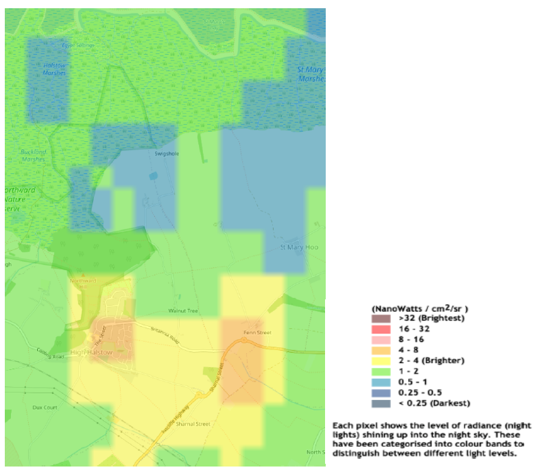
Figure 13: Light pollution In High Halstow, (source: https://www.nightblight.cpre.org.uk/maps/)
18 See https://explorekent.org/activities/heron-cycle-trail-the-hoo-peninsula/ accessed July 2020
19 Medway Council, March 2011, Medway Landscape Character Assessment
20 Medway Council, November 2008, State of Medway Report: Natural Assets and Open Space
21 Information in this paragraph provided in correspondence from the RSPB, November 2020
23 Medway Council, March 2011, Medway Landscape Character Assessment
24 Medway Council, February 2019, Hoo Landscape Sensitivity & Capacity Study (draft)
25 Medway Council, November 2017, Medway Heritage Asset Review 2017
26 Para 102, MHCLG, July 2021, NPPF
27 Aecom for the lead local flood authorities of the South East of England, Water, people, Places: A guide for master planning sustainable urban drainage into developments. See: https://www.medway.gov.uk/info/200150/planning_guidance/647/sustainable_drainage_systems (accessed September 2020)
28 BREEAM UK, 2014, Non-domestic Buildings (United Kingdom), Technical Manual SD5076 4.1
31 Proposals shall refer to the forthcoming Heath Mapping and Energy Masterplanning study to be prepared by Medway Council and the recommendations included in that
32 CPRE Night Blight. See: https://www.nightblight.cpre.org.uk/. Brightness values are measured in nanowatts: the higher the measure of nanowatts the brighter the light