High Halstow Neighbourhood Plan - Regulation 16
6. Movement
6.1 The policies and projects contained within this section of the Neighbourhood Plan relate to the objectives below and are summarised in Figure 14.
Access to the countryside
6.2 The village of High Halstow is surrounded by attractive countryside, providing opportunities for leisure and recreation for all to enjoy, and it also benefits from an extensive network of footpaths and public rights of way. These complement the road network and connect the village to the surrounding countryside and neighbouring settlements. The Rights of Way network across the Parish is illustrated in Figure 15 and includes two rights of way running through land to the east of High Halstow allocated for development. These routes connect The Street with Britannia Road on an east west axis, and Britannia Road with Christmas Lane, running north south through the site.
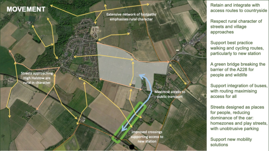
Figure 14: Indicative concept plan showing summary of aspirations for access and movement in High Halstow (image source: Google Earth).
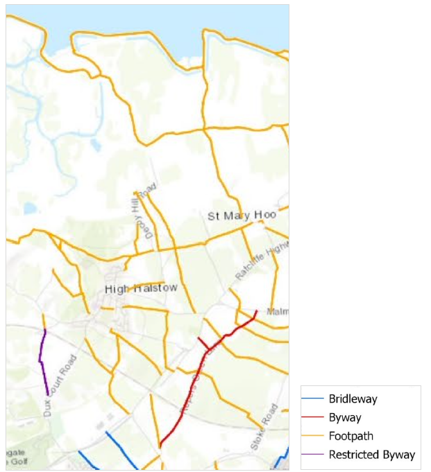
Figure 15: Plan of existing rights of way network in High Halstow (source: Medway Council, May 2020, Medway Rights of Way Improvement Plan, 2020-2030)
6.3 Medway Council has prepared a Rights of Way Improvement Plan (ROWIP)33. This sets out the priorities and actions for improving Public Rights of Way across the Medway administrative area over the ten year period 2020-2030, with a focus on providing opportunities for all to access the countryside as well as making active lifestyle and sustainable travel choices.
6.4 Public access routes in High Halstow include footpaths, bridleways, byways and cycle paths. For the purposes of the Neighbourhood Plan, these are termed 'green routes'. These help promote healthy lifestyles and reinforce High Halstow's natural landscape character. All existing green routes should be retained and incorporated within proposals for development. Any diversion or stopping up on an existing route will be subject to an application for permission.
6.5 Any proposed new routes that complement the existing network of public rights of way in High Halstow, or improvements to existing routes, should be delivered in accordance with best practice principles for design and maintenance. Sustrans, for example, recommends that cycle routes should include a smooth surface with good drainage properties and long-term durability. Handbooks for cycle route design34 and greenway management35 published by Sustrans are a source of best practice for implementing and maintain routes for all. Reference as appropriate should also be made to Ramblers Advice and British Horse Society Advice notes.
Policy HH M1: Green routes
- Where existing green routes run through proposed development sites the green route shall be retained and incorporated into the development proposals. Such routes should be fully integrated within the layout and form of development, with active frontages overlooking them, providing natural surveillance and encouraging use. The stopping up of green routes will be strongly opposed. Any proposal that would result in the loss of a green route or change which might undermine the quality of the route must be justified and any harm minimised.
- The provision of improved green routes and new green routes, is strongly encouraged. Where new routes, or improvements to existing routes, are provided, they should accord with best practice design principles, including those established by Sustrans in the 'Handbook for Cycle Friendly Design' and 'Greenway Management Handbook'.
6.6 The Parish benefits from the presence of the coastal path which runs along the coastal marshes and provides a strong east west link. This is however undermined by poor north south connectivity to villages on the Peninsula, including High Halstow. This is recognised in the Medway landscape Character Assessment which notes that the footpath network, and in particular north south links to the coastal path, should be improved. At present, because of the gaps in the network, as well as topography which can be challenging in parts, access to the coastal path is restricted for some, with the car being used by others. The Parish Council is keen to explore opportunities to improve connectivity with the coastal path for people on foot and bicycle. This is identified as a Project / Aspiration in the blue box labelled HH Ma below.
Project / Aspiration HH Ma: Links to Coastal Path
- The Parish Council is keen to work with partner organisations to explore the feasibility of delivering new links between the village and the Coastal Path. The feasibility exercise will need to include assessments of the environmental impacts of any proposed routes.
- Routes shall be well-signed and useable in all weathers. As with Policy HH M1: Green routes, such a link should be designed in accordance with best-practice principles.
Active travel (walking and cycling)
6.7 High Halstow is relatively isolated from main towns and settlements within Medway, and it is recognised that, given this context, many journeys will still take place by car. However, and set in the context of the Climate Emergency, alternative forms of movement will need to be explored. Indeed, this message was made through feedback to community consultation and extends to include support for an increase in walking and cycling, particularly for short journeys within the Parish, public transport (both bus and rail), and use of E-vehicles. This is reflective of the hierarchy of movement established in national policy and the emerging Local Plan for Medway. Furthermore, and as indicated in the breakdown of the carbon footprint for the parish (Figure 4), transport is a major generator of carbon dioxide emissions. Introducing more sustainable and active forms of travel, and which are attractive to all to use, will help contribute to reduce the carbon footprint.
6.8 The main built-up area of High Halstow is relatively compact, with walking possible across much of the area, with good links existing between homes, parks and community facilities, and with a network of public rights of way extending into the countryside.
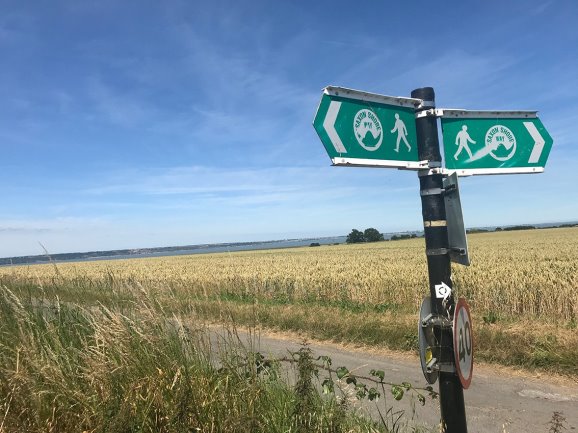
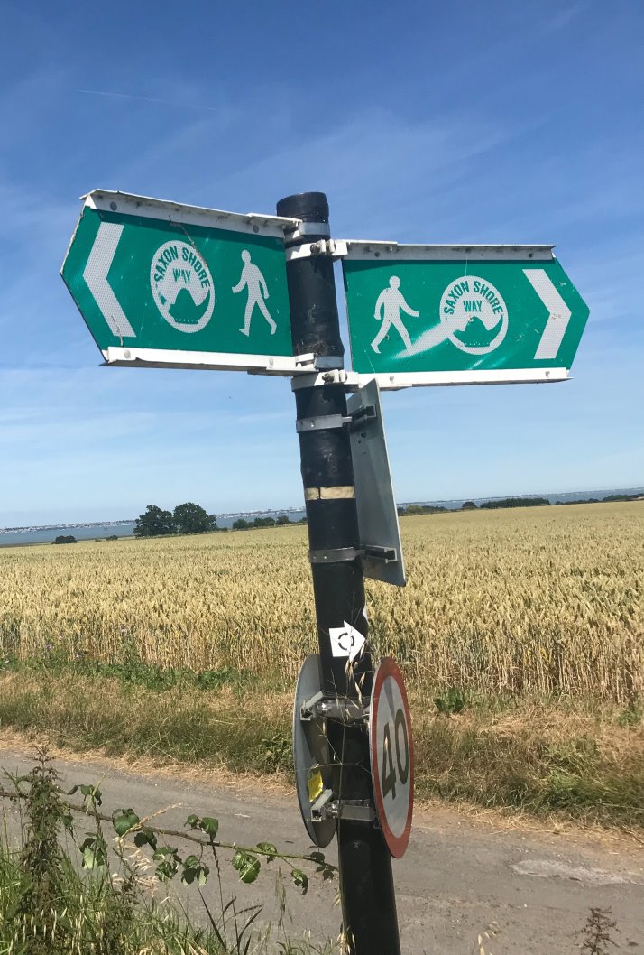
Figure 16: The Saxon Shore Way
6.9 With future growth to the east of High Halstow the village, and distances travelled, will increase. However, with the provision of a good network of connected walking and cycling routes it should be possible to walk between the existing and new development area and, for slightly longer journeys, cycling distances should remain comfortable for all.
6.10 Efforts to make walking and cycling the 'norm' for short journeys should be prioritised. Indeed, this is now required by the Government, with the updated Traffic Management Act36 requiring local authorities to introduce new measures that make walking and cycling safer and more attractive propositions for all people of all ages and abilities.
6.11 The Government's Cycling and Walking Investment strategy37 points to the importance of and need for investment in new infrastructure to support active travel. It is recognised that encouraging a mode shift from private vehicles to walking and cycling has many benefits, with research showing that this is good for the environment, for health and social well-being, and for the economy38.
6.12 Although there are numerous public rights of way in the neighbourhood plan area, there is only one signed cycle route: route number 179, also known as the Heron Trail, forms part of the National Cycle Network, linking High Halstow with Cliffe, Hoo St Werburgh, Higham and Strood.
6.13 New development should be based around the idea of filtered permeability, allowing people to walk and cycle conveniently between the home and other destinations. Such an approach also allows connections for deliveries and emergency services, but car access is less direct, reducing through traffic and encouraging a shift away from the car for shorter journeys. Routes should be designed with safety in mind, both from motorised traffic but also from crime and concern for personal safety. Where new routes are created within development, these should be overlooked, with active frontages, created by windows and doors, opening onto the street. They should also be well-lit to allow safe movement at night time. Routes that are located to the rear or between properties, and which are enclosed by garden fences, vegetation or blank walls are discouraged.
6.14 To make cycling an attractive proposition new and existing routes must be segregated from motorised traffic on high-volume roads. Safe crossing points should be provided at junctions. In quieter residential areas cycling may be incorporated within the street, though streets should be designed with slow speeds and the mixing of users in mind. Shared space schemes in quieter residential areas may be appropriate, and should form part of a landscape-led approach to the design of the space. Cycle parking should be located close to the entrance of new homes and other buildings, with changing facilities provided where appropriate. The design of new cycle infrastructure should be appropriate to place, reflecting local character and identity.
Policy HH M2: Active Travel
- All applications for major residential and commercial development as well as community facilities must demonstrate how they support active travel through delivery of new walking and cycle routes, and or improvements to existing routes, reducing reliance on motorised vehicles.
- Where new walking and cycling routes are provided they must be direct, safe and convenient to use. They must be designed for use by all people, of all ages and abilities, including those with baby-buggies, using frames or wheelchairs.
- The layout of proposed development will allow for the natural surveillance of routes through overlooking with active development frontages.
- Where there are existing walking and cycling routes within or adjacent to a development site, proposals for development are required to show how they link into these networks. Proposals must not result in the loss of existing walking or cycling routes, nor reduce the capacity or safety of that infrastructure.
- Where new cycle routes are provided, they will reflect best practice principles and should be designed such that they can be used in all weather conditions.
- Proposals for residential development shall provide secure cycle storage assigned to the dwelling. This must be located within or immediately adjacent to the property, fully-enclosed and at ground-level.
- Proposals for commercial, leisure and community uses should support and enable active travel through inclusion of safe, secure and convenient cycle parking and changing facilities where appropriate. This must include provision of dry and secure cycle parking.
Project / Aspiration HH Mb: New walking and cycle routes
- The Parish Council is keen to work with partner organisations to explore the feasibility of delivering new and or improved walking and cycling routes in the Parish, including:
- Routes between the existing settlement area, development on land to the east of High Halstow and the proposed new railway station.
- A green bridge across the A228 that provides safe crossing for people and for wildlife.
- Improved connections to the coastal path from the existing settlement area.
Public transport (bus and rail)
6.15 It is recognised that not everybody will be able to walk and cycle, and that for some purposes, it will be necessary to travel longer distances, particularly for work and other activities that have a wider regional function, including, for example, universities, hospitals and cultural activities. Bus services can provide a viable and sustainable alternative to the car. However, where bus services are limited then it can result in disconnected communities, reliance on the car (thus contributing to pollution and congestion), increased isolation and cost of living. Perhaps most significantly the Campaign for Better Transport states that:
'The loss of good bus links can undermine whole communities, creating places where non- car households cannot easily live. Loss of bus services hinders people's access to work, learning, healthcare, choice of shops and social, cultural and sporting activities, and makes vital services, such as doctor's surgeries, more difficult to reach'.39
6.16 The importance of the bus network to social cohesion and inclusiveness is emphasised in statistics from the Department for Transport which show journey times to services in rural areas are around double that in urban areas40, and that 60 percent of all road fatalities occur on country roads: almost eleven times higher than on motorways41. People in rural areas are thus being asked to travel further and potentially at greater risk.
6.17 Public Transport provision to and from High Halstow, and the Hoo Peninsula as a whole, is limited. Bus (and Coach services) are infrequent and include 'specialist services' as listed below, as well as school and long distance commuter services42.
- Route 10: High Halstow – The Hundred of Hoo Academy (school service)
- Route 191: Grain – Lower Stoke – Allhallows – Hoo – Rochester – Chatham
- Route 193: Cliffe – Hoo – Rochester – Chatham (Sundays only)
- Route 692: Lower Stoke – Allhallows – Hoo – Rochester Grammar Schools (school service)
- Route 765: Kingsnorth – Hoo – Strood – London (coach/commuter service)
- Route 796: Grain – Lower Stoke – Allhallows – Chatham
6.18 The limited nature of the bus service was raised by the community in consultation events, stating that, for the majority of the day, there is only one bus every two hours and that if there is a cancellation (as is often the case) then it can mean a four hour wait for the next bus. This clearly disadvantages many people, including all those who do not have access to a private car.
6.19 In High Halstow it is therefore important that investment in walking and cycling infrastructure is matched by a commitment to improving the quality and frequency of the bus service for the benefit of all residents. Indeed, this echoes recommendations in the Governments 'Bus Back Better' strategy43.
6.20 Any future growth of High Halstow to the east must allow for the incorporation of bus routing through the site and into the existing village, such that all residents are within walking distance of a bus stop. Comfortable walking distances to bus stops for able- bodied people are around 300-400 metres, equivalent to a five minute walk. Bus stops within any future growth area on land to the east of High Halstow shall be located to minimise walking distances to these. This also means providing for a permeable network of walking routes to and from the bus stops, as well as good waiting facilities and service information that encourage their use.
6.21 From the future growth area on land to the east of High Halstow bus routes are likely to make use of Christmas Lane, Britannia Road and Ratcliffe Highway. Junction improvements and bus priority measures that help support more efficient services at these points are welcome. Best practice guidance on bus routing and infrastructure within new housing developments should be referred to44.
Policy HH M3: Bus services, routes and infrastructure
- Proposals for development should respond to the need to reduce the generation of road traffic and help reduce air and noise pollution. Development will, where appropriate to the scale of proposals, incorporate sustainable transport measures, including new bus routing, new or improved waiting facilities, including real time information, and or accessibility to services, which may include new crossing points next to bus stops.
- Infrastructure for new bus services should be provided that links development on land to the east of High Halstow with the existing village area and the proposed new railway station to the south of the Parish.
- As part of development on land to the east of High Halstow provision for bus routing must be made from the site. Bus stops should be located so that all residents are within walking distance of a bus stop. Streets must be carefully designed to balance the needs of competing users and avoid conflicts between bus users, pedestrians and cyclists.
- The provision of bus priority measures will be supported as part of the growth area, enhancing bus access and service efficiencies between High Halstow and the new railway station. This may involve the remodeling of the Christmas Lane / Ratcliffe Highway roundabout.
6.22 The Housing Infrastructure Fund awarded to Medway Council will support the provision of a new rail passenger station at Sharnal Street, located immediately outside the parish boundary. Although the Neighbourhood Plan can only set policies for land within the Neighbourhood Area, it is important that development of the station and any major growth in High Halstow is undertaken holistically.
6.23 To be an effective and attractive transport option the station will need to be easily accessible and integrated with the wider movement network, allowing for journeys to and from the station by foot, bicycle and public transport. Convenient step-free access combined with secure and covered cycle storage should be provided, with bus stops located close to the station entrance.
6.24 Access by foot or bicycle to the station will require users to cross the A228 Ratcliffe Highway. This is a busy road with fast moving traffic and a record of accidents (see Appendix 3). Safe crossing points are thus required and, for these to be used as the default choice must be available upon opening of the station. Various options for provision of safe crossings exist, though the preference would be for a green bridge, allowing seamless foot and cycle access across the A228, connecting with the existing network of public rights of way. This could also make use of the existing topography along the A228. Indeed, the Medway Council publication, 'Planning for Growth on the Hoo Peninsula', envisages provision of a green bridge along the A228 to 'provide easy access across the A228'.
6.25 A green bridge would also have wider benefits in providing safe crossing points for local wildlife and linking in with wider ecological networks. This is recognised by Natural England45 whom welcome provision of such bridges as they allow wildlife movement, stop species from becoming isolated, and reduce traffic accidents. Research for Natural England draws upon the green bridge across the A21 at Scotney Castle which is in Kent in the High Weald Area of Natural Beauty and relatively close to High Halstow. This provides access, landscape and habitat connectivity.
Policy HH M4: Rail services, routes and infrastructure
- Proposals for growth to the east of High Halstow shall incorporate provision of new walking and cycling links between the village, growth areas and railway station.
- These routes should be direct, well-lit (with low level lighting) and available to use in all weather conditions.
- Safe crossing points must be provided across the A228 Ratcliffe Highway for pedestrians, cyclists and, as far as possible, wildlife, facilitating safe movement between High Halstow and future railway station. This crossing point should connect as seamlessly as possible to existing public rights of way and should take the form of a green bridge.
- The crossing point shall be provided at the same time and ready for use upon opening of the station.
Street design and safety
6.26 The sense of connection to the main towns within Medway (such as Rochester) is key to the rural character and identity of the Parish and the main built-up area of High Halstow. Country lanes are more typical than dual carriages and main roads in the road network on the Peninsula.
6.27 Access to and from the Hoo Peninsula is restricted to the A228 which leads into Strood and then on to Rochester. From High Halstow access to the A228 is via Christmas Lane or Dux Court Road.
6.28 Although the junctions of Christmas Lane and Dux Court Road with the A228 comprise key gateways into the village they can equally be points of congestion. The nature of these junctions and the presence of traffic travelling at higher speeds on the main road helps explain why there have been several recorded traffic incidents across the two access points since 2015. There have also been several recorded traffic incidents along The Street, which is the main route running through High Halstow46.
6.29 Initiatives that improve traffic safety are thus welcome, including reconfiguration of existing road and junctions, as well as designing roads and streets within areas of new development that allow for the safe movement of all. This is recognised by Medway Council in the 'Planning for Growth on the Hoo Peninsula' document, which states that:
Certain forms of street layout are more likely to be conducive to walking and cycling. Design considerations are also important factors for specific groups and contribute to making high-quality places.
'Home- Zones' can encourage more street and community activities through the integration of play, socialising and car parking. Parking for bicycles and large vehicles including commercial vans will also be a vital part of the key design process and not introduced as an afterthought'.47
6.30 Indeed, the updated Traffic Management Act published by the Government in May 202048 expects local authorities to make significant changes to road layouts to give more space to pedestrians and cyclists and, by extension, make them safer places for all, supporting active and healthy lifestyles.
6.31 The safety of the highway network, for all users, is of paramount importance to the Parish Council. The Parish Council is keen to work with Medway Council, as highway authority, as well as other relevant organisations, to identify and deliver traffic management measures that improve safety for all.
6.32 Within the future growth area at land to the east of High Halstow the application for development should include a street hierarchy, illustrating cross-sections through different street typologies. Streets should be designed to facilitate safe movement by all and reflect guidance as outlined in Manual for Streets. Design features should be incorporated that discourage speeding. A set of example street types area illustrated in the High Halstow Design Code and should be used to inform proposals for new development areas. Equally, these examples can be used as a basis for thinking about retrofitting existing streets in High Halstow.
6.33 All four roads into the village (Dux Court Road, Christmas Lane, Britannia Road and Cooling Road – see Figure 17) are rural in character and all being of varying width with passing places. Dux Court Road and Cooling Road in particular are historic routes and reflect the rich heritage of the ancient movement network in rural Kent. Those parts of both routes within the parish are protected rural lanes. All are an important and defining characteristic of the village's rural identity. This identity can be easily lost by the addition of highway paraphernalia, such as lighting, bollards, signage, road markings etc or by engineered improvements or the loss of rural features such as hedges, verges and ditches. It is recognised that there is a need for provision of safe routes for cyclists and pedestrians to access the new station proposed at Sharnal Street. Where new routes are to be provided they should be well integrated with the landscape and seek to preserve and enhance the natural character and landscape of the rural lanes. Urbanising features shall be avoided wherever possible, except where that road section already incorporates such features (e.g.: footways) or where required for road safety purposes.
Policy HH M5: Street design
- Proposals for land to the east of High Halstow shall be based around a permeable street network that is safe for people to travel around by foot and by bicycle. Culs-de-sac should be avoided where possible.
- A hierarchy of streets shall be integrated within the growth area, reflecting different characteristics and responding to guidance illustrated in the forthcoming High Halstow Design Code. Blank frontages to streets must be avoided.
- Proposals for play streets and homezones within new development areas will be supported, including shared spaces, greenery, traffic calming and low speed limits.
- Proposals for development and engineering works, including proposals for development which obtain access from the existing rural roads (Dux Court Road, Christmas Lane, Britannia Road and Cooling Road) must ensure that they are designed to protect and enhance the rural character of them. Schemes for development east of High Halstow will seek to provide off line, segregated cycle and pedestrian routes adjacent to Britannia Road and Christmas Lane where possible. The character of Brittannia Road and Christmas Lane, reflected in its width and presence of vegetation along it, shall be retained, but with a segregated pedestrian and cycle route running parallel to though set back from the road alignment.
- Those parts of Dux Court Road and Cooling Road within High Halstow parish are protected rural lanes. They will be protected and enhanced. Any proposal that would result in harm or loss must be justified. Any alterations to the protected rural lanes should not adversely impact upon the landscape value nor historic significance of the lane and must make use of materials that reflect the character of the lane. Urbanising features shall be avoided wherever possible.
Project HH Mc: Traffic management and safety
1. The Parish Council will liaise with Medway Council to prioritise improvements to the highway network across the Parish which include the redesign of (i) key junctions to make them safer for all, and (ii) roads, particouncil to ularly those through the built-up areas, to reduce traffic speeds and provide improved conditions for pedestrians.
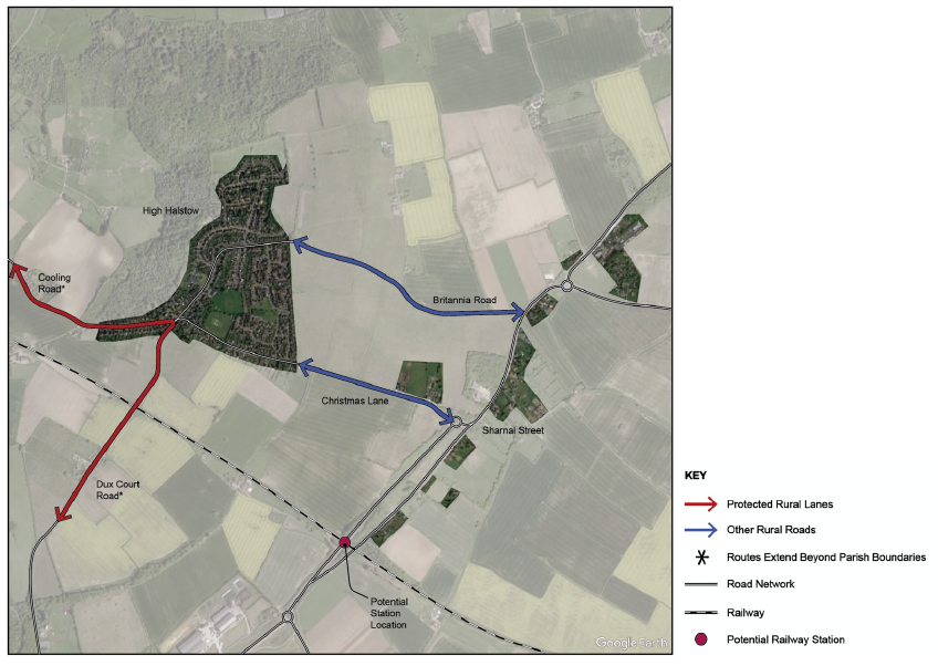
Figure 17: Rural roads in High Halstow (map source: Google Earth). Note: more recent plans prepared by Medway Council show the station being located further east of the Ratcliffe Highway than indicated in this figure.
New technology and transport solutions
6.34 Technological solutions associated with mobility are evolving at a rapid pace. With Medway Council having announced a Climate Change Emergency it is important for new development to embrace new ideas that provide wider choice and opportunity for people to access a range of greener transport options.
6.35 The House of Commons cross-party Science and Technology Select Committee has reported49 that, if the UK is to meet climate change targets, then transport solutions are required. It reports that 'in the long-term, widespread personal vehicle ownership does not appear to be compatible with significant decarbonisation'. Improvements in public transport, walking and cycling are supported.
6.36 The Government is committed, through the 'Road to Zero' Strategy50, to half of all new car sales being ultra-low emission vehicles by 2030 (with the sale of all petrol and diesel vehicles phased out by 2040), whilst also rolling-out the necessary infrastructure to support provision of electric vehicles. The National Infrastructure Audit51 goes further than this and includes recommendations that are based on preparing for the sale of all new cars by 2030 to be electric. More recently, the Government has launched a consultation52 on proposals to make it mandatory for all new homes to be fitted with an electric car charging point.
6.37 It is recognised that people in High Halstow will continue to own cars, and that they will continue to be used for some journeys. The provision of new technology and mobility solutions though is intended to provide wider choice and opportunity for all, reducing reliance on private car ownership and use, contributing to an improved environment.
6.38 Support will be given to projects and proposals that embed new technologies, providing a wider range of choice and opportunity for all. Such technology must be designed such that it does not cause obstruction within the public realm (e.g.: e- vehicle charging points and cables placed on the footway which impede pedestrian movement).
6.39 Mobility as a Service (MaaS) is an emerging transport model that challenges the traditional concept of private car use and ownership. In its current form, MaaS is an app-based product that enables customers to access a journey planner to show which routes and combination of travel modes are available to them, including public transport, docked hire vehicles or on-demand services. Research published by the Government53 acknowledges that MaaS will transform the way in which people travel, and that this needs reflecting policy decisions. The research states:
'MaaS potentially offers a paradigm shift from transport being fundamentally provider-led (i.e.: where fixed capacity is provided to service a predictable demand), to being a fully user-led system whereby the level and type of transport supply continually adjust in response to the specific desires of individual travellers.'
6.40 Such services can be provided within publicly accessible mobility hubs, providing choice and opportunity, but also integrated with other services, such as parcel collection points, responding to the increase in home delivery arising from the Covid Pandemic.
6.41 Proposals for new development in High Halstow should be future-proofed and embed new technology and mobility solutions that provide wider choice and opportunity for all, which reduce reliance on private car use and ownership, and which contribute to an improved environment. All new homes should be supplied with super-fast charging points, reflecting guidance from the Institute of Air Quality management and as consulted upon by the Government in proposed changes to Building Regulations.
Policy HH M6: E-vehicles, Mobility as a Service and Mobility Hubs
- Proposals for communal e-vehicle charging points, including super-fast chargers, and shared mobility infrastructure within the public realm are encouraged.
- Where proposed, such infrastructure should be located sensitively to ensure that there are no harmful impacts upon pedestrian circulation or the immediate appearance of the street scene and wider townscape. Wherever possible, EV charging infrastructure, such as cabling, should be provided in such a way that it can be expanded in the future to provide additional charging points and accommodate faster charging technology.
- Proposals for EV infrastructure and mobility hubs will be supported in the following locations, subject to compliance with wider policies in the Development Plan and any forthcoming EV Strategy to be published by Medway Council:
- Within the car park adjacent to the Village Hall.
- Within the area of land allocated for development to the east of High Halstow, including any new 'community hub' areas.
- At the proposed new rail station to the south of the Parish.
- All new homes shall be fitted with e-vehicle charging points.
33 Medway Council, May 2020, Medway Rights of Way Improvement Plan 2020-2030
34 Sustrans, April 2014, Sustrans design manual: Handbook for cycle-friendly design
35 Sustrans, June 2016, Sustrans design manual: Greenway management handbook
36 Department for Transport, May 2020, Statutory Guidance, Traffic Management Act 2004: network management in response to COVID-19
37 https://www.gov.uk/government/publications/cycling-and-walking-investment-strategy accessed July 2020
38 See, for example, the Health Economic Assessment Tool (HEAT) developed by the World Health Organisation (Europe) which is designed to help conduct economic assessments of the health benefits of walking or cycling by estimating the value of reduced mortality that results from specified amounts of walking or cycling (https://www.heatwalkingcycling.org/#homepage). Also, see, London School of Economics, 2011, The British Cycling Economy: Gross Cycling Product (http://eprints.lse.ac.uk/38063/), and Arup for Victoria Walks, 2018, The economic case for investment in walking
39 Campaign for Better Transport, September 2019, The Future of the Bus: policy and fiscal intervention as part of a National Bus Strategy
40 Department for Transport, 2014, Journey Time Statistics: Access to services
41 Department for transport and Robert Goodwill MP, 14 October 2014, Country roads deadlier than you THINK! Press release
42 https://www.arrivabus.co.uk/kent-and-surrey/floating/medway/medway-bus-routes/?tax=112681 and https://bustimes.org/localities/high-halstow
43 DfT, 2021, Bus Back Better, National Bus Strategy for England
44 CIHT, January 2018, Buses in Urban Developments
45 Natural England, 2015, Green Bridges: A literature review
46 CrashMap: https://www.crashmap.co.uk/Search
47 Medway Council, March 2020, Planning for Growth on the Hoo Peninsula
48 Department for Transport, May 2020, Traffic Management Act 2004: network management in response to COVID-19
49 https://www.parliament.uk/business/committees/committees-a-z/commons-select/science-and-technology-committee/news- parliament-2017/clean-growth-report-published-17-19/
50 https://www.gov.uk/government/news/government-launches-road-to-zero-strategy-to-lead-the-world-in-zero-emission-vehicle- technology
52 https://www.gov.uk/government/news/electric-car-chargepoints-to-be-installed-in-all-future-homes-in-world-first
53 Foresight, Government Office for Science, December 2018, Mobility as a Service (Maas) in the UK: change and its implications